Big Scaly Mountain Loop Backpack | |||||||
| The Basics: | |||||||
| Event Type: | Backpacking | ||||||
| Event Location: | Big Scaly Mountain, NC | ||||||
| Date(s) & Time: | Fri, Mar 20 2026 8:30 am >> Sun, Mar 22 2026 5:30 pm (Carpool Departure: 8:30 am *log in for location*) | ||||||
| Registration Opens: | Tue, Mar 17 2026 8:00 pm | ||||||
| Registration Cut Off: | Thu, Mar 19 2026 11:00 am | ||||||
| Event Duration: | 2 Days 9 Hours | ||||||
| Difficulty Rating: | D5: Difficult | ||||||
| Distance: | 11 Miles | ||||||
| Pace: | Moderate | ||||||
| Trip Leader(s): | Michael J Nahid  Email Trip Leader(s) Email Trip Leader(s)
You must be logged in to get the Trip Leader contact information. | ||||||
| Member Cost: | None | ||||||
| Participant Info: | |||||||
| Who's Invited: | Members Only, 21 And Older Only | ||||||
| Maximum Group Size: | 8 | ||||||
| Minimum Group Size: | 3 | ||||||
| Number Registered So Far: | 7 / 0 (To see who's signed up, log in to the Member Area) | ||||||
| Are Dogs Permitted: | Yes | ||||||
| Itinerary: | |||||||
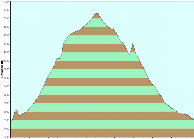
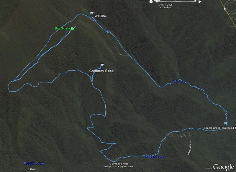
How about joining us for the start of the spring season of '26 with a 2 night camping trip into the Southern Nantahala Wilderness! Big Scaly is the mountain just below Standing Indian. This backpack is a loop of about 11 miles and has roughly 2,500 feet of elevation gain (and loss...see trail profile below). If you have not completed a D5 hike or backpacked recently, expect to have some conversation with a trip leader prior to the event. Depending on who participates in the carpool, we might skip a mile of the hike along the road by having a car available for a short shuttle between the two points of our hike. If not, the gravel road is actually kind of cool, for a road, since it follows the Tallulah river on a gravel road. We'll hike clockwise, on the Chimney Rock Cliffs trail, just past Case Knife Gap, to a nice campsite along Beech Creek in the saddle between Big Scaly and Standing Indian. After setting up camp, and collecting some firewood together, we can explore the surrounding areas. There's options to walk along Beech Creek, or hike up to the top of Big Scaly. You can also opt to just hang around camp. It's a beautifui saddle nested between two iconic mountains, nestled within the Southern Nantahala Wilderness. On Saturday we can discuss how you want to spend the day, again by either exploring the area, or just hanging around in camp. Bonus to anyone bringing a saw for trail clearing if needed. Then we either walk a mile down to the end of the FS road or complete the shuttle. | |||||||
| |||||||
| How to Get There: | |||||||
| Event Directions: | Take I-85 N to I-985 N which turns into US 23/441 to Clayton GA. Pit stop at Chik Fil A! (For bathrooms and "to go" only - we do not plan to sit down and eat.) Then go West on US 76 about eight miles. Turn right on Persimmon Rd, near the volunteer fire department and sign for Tallulah River Campgrounds. Continue about 4.2 miles to left at Tallulah River Rd. This road will turn to gravel after a mile or so and leads thru gorge to Tate City. Follow to NC state line. Trailhead parking will come up soon on the left. | ||||||
| Carpool to Event Distance (round trip): | 220Mile(s) | ||||||
| Carpool Departure Time: | 8:30 am | ||||||
| Carpool Location: | Log in for location | ||||||
| Carpool Directions: | Log in for directions | ||||||
| Carpool Cost: | Estimated cost per vehicle for this event is $88.00 using a reimbursement rate guideline of $0.400 per mile. The total amount should be divided by the number of people in the vehicle, including the driver. This is a guideline, not a rule, for drivers but the cost should not be higher unless there are extenuating circumstances. | ||||||
| Notes: | |||||||
|
* We encourage all members to follow our Etiquette Guidelines while participating in AOC events. | |||||||
Cancellation/Partial Attendance: Please review the AOC cancellation policy. | |||||||