 Print-Friendly Version Print-Friendly Version
|
|
Rabun Bald via Beegum Gap to rock lookout | |||||||
| The Basics: | |||||||
| STATUS: | Cancelled - Hide from Calendar | ||||||
| Event Type: | Hike | ||||||
| Event Location: |
Bartram Trail near Sky Valley, GA


| ||||||
| Date(s) & Time: | Sat, Aug 12 2017 8:00 am >> Sat, Aug 12 2017 8:00 pm (Carpool Departure: 8:00 am *log in for location*) | ||||||
| Registration Opens: | Tue, Aug 1 2017 12:55 pm | ||||||
| Registration Cut Off: | Fri, Aug 11 2017 9:00 pm | ||||||
| Event Duration: | 12 Hours | ||||||
| Difficulty Rating: | D5: Difficult | ||||||
| Distance: | 10 Miles | ||||||
| Pace: | Moderate | ||||||
| Trip Leader(s): | Mike S Dorothea  Email Trip Leader(s) Email Trip Leader(s)
You must be logged in to get the Trip Leader contact information. | ||||||
| Member Cost: | None | ||||||
| Participant Info: | |||||||
| Who's Invited: | Members Only, 21 And Older Only | ||||||
| Maximum Group Size: | 12 | ||||||
| Minimum Group Size: | 3 | ||||||
| Number Registered So Far: | 13 / 0 (To see who's signed up, log in to the Member Area) | ||||||
| Are Dogs Permitted: | No | ||||||
| Itinerary: | |||||||
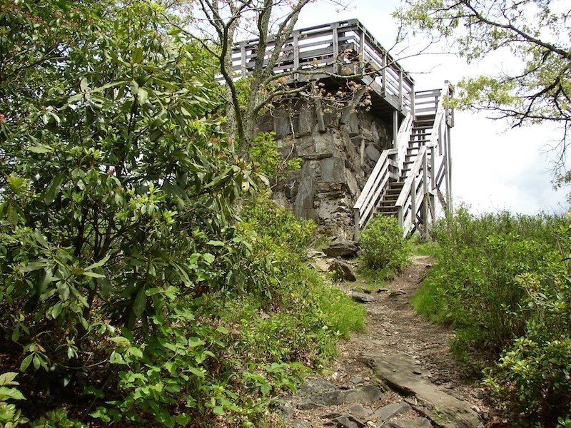
We will start at Beegum Gap and climb 1000 ft over 1.6 miles to the top of Rabun Bald, the second highest mountain in GA. The former fire tower, now lookout platform, affords a fine 360-degree view. After we have had our fill of looking, we will descend on the Bartrum Trail southbound on switchbacks to Flint Gap, pass through Saltrock Gap, which is a large camping area close to a stream, climb up to Flat Top but bypass its summit, and descend gradually to a rock overlook, off-trail and easy to miss. That's about 3 miles. Here we will enjoy another view and lunch, after which we will retrace our steps. Hiking time + time on Rabun Bald + time for lunch should get us back to the cars by 4:30-5:00. Estimated total elevation gain 2800 ft. Mike will coordinate the carpool at the park-and-ride and Dorothea will join the group at the Clayton Ingles (south-west corner). Anyone "meeting at event" should be at the Ingles at 9:15. We plan to have dinner in Clayton after the hike. Anyone who cannot stay for dinner should carpool with like-minded hikers or drive on their own to the Clayton Ingles, where they can join the carpool. Please note that parking is extremely limited at the trailhead, for which reason we will form the smallest possible carpool at the Ingles parking lot.
| |||||||
| |||||||
| How to Get There: | |||||||
| Event Directions: | From Clayton take 441 north. Turn right at lights on to 246/106 towards Highlands. Drive 2.9 miles to Old Mud Creek Rd (at the turnoff there is a scenic service station/store). Note that Old Mud Creek Rd becomes Bald Mtn Rd in Georgia. Drive 2.9 miles and turn sharp right on to Kelsey Mtn Rd, which ends shortly at Beegum Gap. | ||||||
| Carpool to Event Distance (round trip): | 210Mile(s) | ||||||
| Carpool Departure Time: | 8:00 am | ||||||
| Carpool Location: | Log in for location | ||||||
| Carpool Directions: | Log in for directions | ||||||
| Carpool Cost: | Estimated cost per vehicle for this event is $84.00 using a reimbursement rate guideline of $0.400 per mile. The total amount should be divided by the number of people in the vehicle, including the driver. This is a guideline, not a rule, for drivers but the cost should not be higher unless there are extenuating circumstances. | ||||||
| Notes: | |||||||
|
If you have not recently completed a comparable AOC hike, we will be contacting you to determine whether this is the right hike for you. * We encourage all members to follow our Etiquette Guidelines while participating in AOC events. | |||||||
Cancellation/Partial Attendance: Please review the AOC cancellation policy. | |||||||
 Calendar of Events
 Event Places