Big Scaly Mountain Winter Backpack | |||||||
| The Basics: | |||||||
| Event Type: | Backpacking | ||||||
| Event Location: |
Big Scaly Mountain, NC


| ||||||
| Date(s) & Time: | Sat, Dec 14 2019 7:30 am >> Sun, Dec 15 2019 6:00 pm (Carpool Departure: 6:45 am *log in for location*) | ||||||
| Registration Opens: | Tue, Nov 19 2019 8:00 pm | ||||||
| Registration Cut Off: | Thu, Dec 12 2019 10:00 am | ||||||
| Event Duration: | 1 Days 10 Hours 30 Minutes | ||||||
| Difficulty Rating: | D5: Difficult | ||||||
| Distance: | 11 Miles | ||||||
| Pace: | Moderate | ||||||
| Trip Leader(s): | Chuck R Mike Pawloski  Email Trip Leader(s) Email Trip Leader(s)
You must be logged in to get the Trip Leader contact information. | ||||||
| Member Cost: | None | ||||||
| Participant Info: | |||||||
| Who's Invited: | Members Only, 21 And Older Only | ||||||
| Maximum Group Size: | 10 | ||||||
| Minimum Group Size: | 2 | ||||||
| Number Registered So Far: | 10 / 0 (To see who's signed up, log in to the Member Area) | ||||||
| Are Dogs Permitted: | Yes | ||||||
| Itinerary: | |||||||
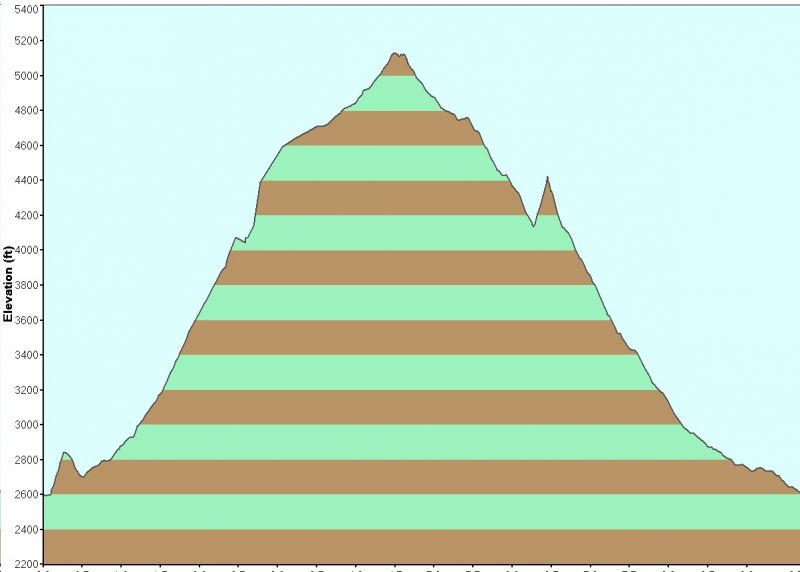
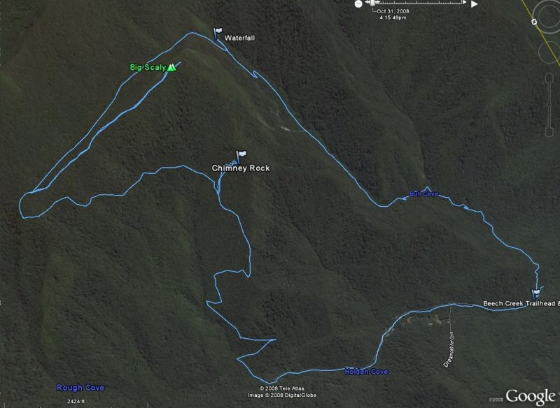
This overnight will take place in the backcountry of the Nantahala Wilderness in North Carolina. We will begin a slow to moderate hike at the North end of the Beech Creek Trailhead.Ā After a ~5 mile hike and 2,000+ ft. elevation gain, we'll stop at a campsite along theĀhigh flat valley below Big Scaly Mountain along the approach to Case Knife Gap.Ā (See elevation profile and route below.)Ā Once at camp, we'll have lunch then go about our chores.Ā These include pitching tents, hanging bear bags, cleaning out the fire ring, gathering firewood (harvesting, transporitng and processing - only standing dead and blow downs.)Ā Please bring wood saws - Sven, Bow, and Silky saws and Corona Saws/Pruners are all tools that work well.Ā It will go a lot faster with 3 saws ("Many hands make lite work".)Ā Plan on filtering your own water at camp.Ā There is a nice small creek running through the area for a water source.ĀĀIn winter camping, hydration is important.Ā You may want to pack in 2-4 liters (1 litre = 2.2 lbs.)Ā For those interested, we can slack pack a short distance (involving a bushwhack) up the south face of Standing Indian Mountain (5,499 ft. elevation) on to the Appalachian Trail for afforded views.Ā Another option after setting up camp is we can take the ~ 1 mile (round trip) trail to the summit of Big Scaly Mountain (5,060 ft. elevation) and enjoy fine long range views. Back at camp we can enjoy dinner around the campfire and share in the fellowship and camaraderie that makes time in the wilderness with friends so special. In the morning, plan on coffee/breakdast by the fire.Ā We'll break camp at a time to be determined by the group. After hiking back to our vehicles, we can make a stop in Clayton for lunch at the U Joint. As always, Mother Nature dictates the schedule.Ā We will be monitoring conditions as the event approaches and will make the appropriate call if the weather looks bad. For those of you not meeting at the car pool, we can meet up atĀChik Fil A! in Clayton.Ā If you have not completed a D5 hike or backpack recently, expect to have some conversation with the Trip Leaders prior to the event. PLEASE NOTE: THIS IS NOT A BEGINNERĀ BACKPACK *** You must be in good physical condition and be able to hike long distances and keep a moderate pace. ***Ā New dogs will be vetted, they must be Trail savvy and nice around
camp. | |||||||
| |||||||
| How to Get There: | |||||||
| Event Directions: | Take I-85 N to I-985 N which turns into US 23/441 to Clayton GA. Pit
stop at Chik Fil A! (For bathrooms and "to go" only - we do not plan to sit
down and eat.)Ā Then go West on US 76 about eight miles. Turn right on
Persimmon Rd, near the volunteer fire department and sign for Tallulah
River Campgrounds. Continue about 4.2 miles to left at Tallulah River Rd.
This road will turn to gravel after a mile or so and leads thru gorge to Tate
City. Follow to NC state line. Trailhead parking will come up soon on the
left. | ||||||
| Carpool to Event Distance (round trip): | 220Mile(s) | ||||||
| Carpool Departure Time: | 6:45 am | ||||||
| Carpool Location: | Log in for location | ||||||
| Carpool Directions: | Log in for directions | ||||||
| Carpool Cost: | Estimated cost per vehicle for this event is $88.00 using a reimbursement rate guideline of $0.400 per mile. The total amount should be divided by the number of people in the vehicle, including the driver. This is a guideline, not a rule, for drivers but the cost should not be higher unless there are extenuating circumstances. | ||||||
| Notes: | |||||||
|
* We encourage all members to follow our Etiquette Guidelines while participating in AOC events. | |||||||
Cancellation/Partial Attendance: Please review the AOC cancellation policy. | |||||||