 Print-Friendly Version Print-Friendly Version
|
|
Estelle Mine, Pocket Loop, and Wildflower Trails + optional activities | |||||||
| The Basics: | |||||||
| STATUS: | Cancelled - Hide from Calendar | ||||||
| Event Type: | Hike | ||||||
| Event Location: |
Crockford-Pigeon WMA


| ||||||
| Date(s) & Time: | Wed, Nov 4 2020 10:00 am >> Wed, Nov 4 2020 8:00 pm (Carpool Departure: 8:00 am *log in for location*) | ||||||
| Registration Opens: | Thu, Mar 26 2020 8:08 pm | ||||||
| Registration Cut Off: | Thu, Apr 2 2020 10:12 pm | ||||||
| Event Duration: | 10 Hours | ||||||
| Difficulty Rating: | D5: Difficult | ||||||
| Distance: | 13 Miles | ||||||
| Pace: | Moderate | ||||||
| Trip Leader(s): | Mark Aaron  Email Trip Leader(s) Email Trip Leader(s)
You must be logged in to get the Trip Leader contact information. | ||||||
| Member Cost: | None | ||||||
| Participant Info: | |||||||
| Who's Invited: | Members Only, 21 And Older Only | ||||||
| Maximum Group Size: | 16 | ||||||
| Minimum Group Size: | 4 | ||||||
| Number Registered So Far: | 4 / 0 (To see who's signed up, log in to the Member Area) | ||||||
| Are Dogs Permitted: | Yes | ||||||
| Itinerary: | |||||||
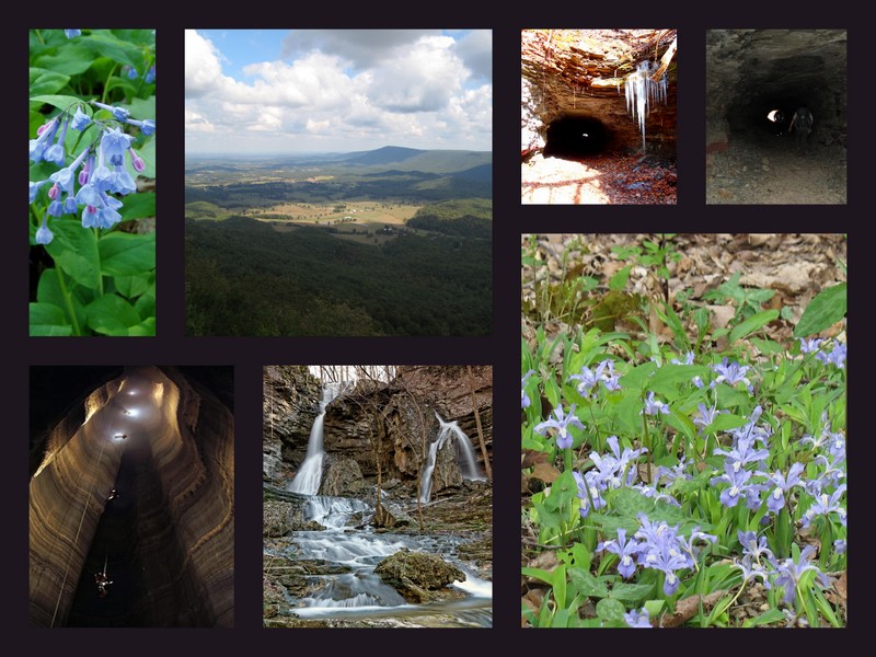
Please read this entire posting before registering for this event - you will be required to have a license/pass to attend this event (see details below). There are also optional activities described in more detail at the end of the itinerary. Summary: The Crockford-Pigeon Wildlife Management Area is 16,400 acres and encompasses most of Pigeon Mountain. The area is known for its many caves and geological rock formations, as well as lookouts, waterfalls, wildflowers, and springs. The WMA has nearly 100 miles of various trails designated for hiking, biking, equestrian, or multi-use. The Crockford-Pigeon WMA is one of many WMAs which require a license or pass for land access. (Please see the notes section for further details on what you will need and options) Prior to starting the event, the trip leaders will verify that each registrant has obtained the proper license/pass. The Hike: After reaching the end of the Wildflower Trail, we will arrive at Pocket Falls... a very nice waterfall cascading over a sandstone bluff. There is a small cave behind the waterfall which we will explore. There is a short rock scramble out of the pocket to get to the next trail, so you should be comfortable with a little rock scrambling. On this next trail we will ascend about 1,400 feet to reach the top of the plateau on Pigeon Mountain. From there we will hike along the rim taking in the view from a few overlooks. We will have lunch at one of these scenic overlooks, which also provides some rock formation exploring opportunities. After a few miles we will then begin our descent down the north side of the mountain on several different trails. We will make a diversion off-trail for a bit until we arrive and at one of the entrances to Ellison Cave, which is one of the deepest caves in the US and has the longest unobstructed pit in the continental US. We won't be doing any serious spelunking (caving), however, some of us may explore a couple hundred feet of the entrance. After leaving Ellison Cave, we will have to travel off-trail for a while until we pick up the next trail down the mountain. The last portion of our hike will take us along the Estelle Mine Trail, which is, in part, on an old abandoned narrow gauge railway used to transport the iron ore which was mined here in the past. This portion of the hike is very cool and unique as we will go through 4 – 5 tunnels, some well over 100 feet in length. Although you can “see the light at the end of the tunnel” in each of these, it gets pretty dark when inside, – too dark to see the very rocky ground on which you will be falling if you don't bring your headlamp or flashlight! The following is a Youtube video which shows much of the Estelle Mine Trail, some of “The Pocket”, and “Pocket Falls”. Although the music, by Patty Lovelace, is about coal mining “holler” in KY, the video is of Estelle Mine area. This is a photo album of a trip Aaron, Jimmy, and I took to Pigeon Mtn during winter. And a photo album of wildflowers Aaron took for a Roots Rated article (https://rootsrated.com/stories/5-best-hikes-for-wildflowers-around-atlanta). After your hike the trip leaders will be eating at Pigeon Mountain Grill, just a few miles from the trailhead. If you do not wish to join them make sure you check with your carpool driver/riders prior to departing the carpool. http://pigeonmtcountrystore.webs.com Optional (non-event) Camping / Activities: Note: This hike is approximately 13 miles, has about 2,300 feet of ascent, has a couple sections of "off-trail" hiking on some steep terrain, and some rock scrambling in one place. Registrants should have recent and solid D4+ hiking experience, or they will be contacted by the TLs to determine if this hike is suitable for their hiking/off-trail/scrambling ability. | |||||||
| |||||||
| How to Get There: | |||||||
| Event Directions: | Hike Parking/Trailhead Location: https://goo.gl/maps/gW4RtPfEE3K2
For those wishing to camp, directions will be provided by email to the campsite on Pigeon Mtn. | ||||||
| Carpool to Event Distance (round trip): | 178Mile(s) | ||||||
| Carpool Departure Time: | 8:00 am | ||||||
| Carpool Location: | Log in for location | ||||||
| Carpool Directions: | Log in for directions | ||||||
| Carpool Cost: | Estimated cost per vehicle for this event is $71.20 using a reimbursement rate guideline of $0.400 per mile. The total amount should be divided by the number of people in the vehicle, including the driver. This is a guideline, not a rule, for drivers but the cost should not be higher unless there are extenuating circumstances. | ||||||
| Notes: | |||||||
|
Carpool:
Pass or License Options: As has been mentioned above, the C-P WMA requires a license/pass for access. There are three options: a Georgia fishing license, a hunting license, or a Land Access Permit. A fishing licese cost $15 for an annual, or $5 for one day. Land Access Permits cost $30 for a year (no short term available). If you plan to hike an any of the 80+ WMAs that require a permit/license in the state, then the annual fishing licese is the most cost effective option. Licenses can be purchased at these locations, or you can get them online.
Optional camping Friday and/or Saturday evening: If you wish to spend one or two nights camping with us, please send Aaron and Mark an email, and let us know of your plans. At minumum include when you will be arriving/leaving. No reservations or fees are required for camping at C-P, although you will need the same license/pass you obtain for the hike. The camping is primitive as there are no toilets/facilities; however, it's car camping, so you can bring pretty much whatever creature comforts you desire. We will have a nice big bonfire each evening. * We encourage all members to follow our Etiquette Guidelines while participating in AOC events. | |||||||
Cancellation/Partial Attendance: Please review the AOC cancellation policy. | |||||||
 Calendar of Events
 Event Places