Sunday Evening Peachtree Corners Hike Around Simpsonwood Park | |||||||
| The Basics: | |||||||
| Event Type: | Hike | ||||||
| Event Location: |
Peachtree Corners


| ||||||
| Date(s) & Time: | Sun, Jun 7 2020 6:30 pm >> Sun, Jun 7 2020 8:00 pm | ||||||
| Registration Opens: | Wed, Jun 3 2020 11:00 am | ||||||
| Registration Cut Off: | Sun, Jun 7 2020 6:15 pm | ||||||
| Event Duration: | 1 Hours 30 Minutes | ||||||
| Difficulty Rating: | D2: Easy to Moderate (Exploratory) | ||||||
| Distance: | 5 Miles | ||||||
| Pace: | Moderate | ||||||
| Trip Leader(s): | Tom Jarosz Email Trip Leader(s) Email Trip Leader(s)
You must be logged in to get the Trip Leader contact information. | ||||||
| Member Cost: | None | ||||||
| Participant Info: | |||||||
| Who's Invited: | Members Only, 21 And Older Only | ||||||
| Maximum Group Size: | 10 | ||||||
| Minimum Group Size: | 4 | ||||||
| Number Registered So Far: | 10 / 0 (To see who's signed up, log in to the Member Area) | ||||||
| Are Dogs Permitted: | Yes | ||||||
|
Note: This is an "EXPLORATORY" trip. This means that there are parts of this trip, or perhaps the whole trip, that is new to your Trip Leader(s). However, they are confident that this will not be an issue. This note is here so that you can make an informed decision. When a Trip Leader isn't personally familiar with a trip, there is an increased chance of things not going as planned and you need to be prepared. The Trip Leader may have additional details in the itinerary. | |||||||
| Itinerary: | |||||||
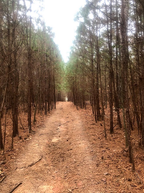
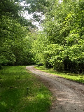
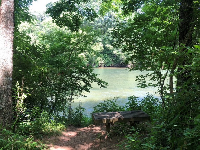
Join us for a Sunday evening exploratory hike in the winding forest footpaths of Simpsonwood Park! We will explore and hike around the park for approximately 4.5 - 5 miles and take a break next to the river. Feel free to bring your dog, if you have one, but must be kept on a leash :) Simpsonwood Park is located and hidden in the peaceful residential neighborhood of beautiful Peachtree Corners - not too many people are aware of its existence. From the edge of Simpsonwood forest, you can view Jones Bridge Park (NRA) across the river and also catch a view of animal life on the river. We'll plan to meet in the Simpsonwood Park parking lot, on the left side, at the beginning of the park entrance. At the end of the hike, you're welcome to pull up a blanket or chair and hang out (Socially distancing of 6 feet) at the open grassy field of the park while the sun sets. It is common to see deer in the open field and along the forest line in the evening. (This is an exploratory hike so hiking distance and finish time is only an approximate estimate. Enjoy the adventure as we explore and learn about Simpsonwood together!) https://atlnature.com/blog/simpsonwood-park
2. Restrooms are available. 3. Social distancing and CDC COVID-19 guidelines and recommendations will be followed 4. If you're a Garmin user, please join our 'Atlanta Outdoor Club (AOC) Garmin Users' group to connect with other AOC Garmin users and track your activity. Join us at: https://connect.garmin.com/modern/group/2255568
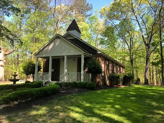
Thanks to the request of Miss Ludie Simpson, the most recent of the Simpson family to own the land, folks will forever enjoy nature in its preserved state. First an Indian trading post, the retreat has seen decades of change but, luckily, remains mostly untouched by developers...For centuries, Cherokees and Creeks roamed this section of forest that borders the Chattahoochee River, carrying furs, animal skins, beaded head dresses adorned with feathers and even gold to trade with one another. By the early 1800s, the Natives were friendly traders with the first "white" settlers as well. Near the entrance of today's United Methodist Retreat Center, an informed eye may spot a tree shaped like the letter "Y" and an elbow-like bent hardwood near the creek that seems to point towards the mouth of the river. Both are suspiciously similar to bent "marker" trees that are being studied today by stewards wanting to prove or disprove their existence. Some tree huggers and historians believe Natives tenderly bent saplings in various shapes to mark trails, likely around 1820, when the federal government took over massive land expanses. The markers are said to indicate the presence of water, guard buried gold and lead the tribes back to their God-given lands. During the early years, before the removal of the 1840s, Natives may have cooked group meals on the embers smoldering in a large stone fire pit still standing next to the chapel on the property. Did they play an early form of La Crosse there on the open field? History notes the game, often played to the death, was used as a way to resolve territorial disputes or a chance for a brave to capture the heart (and the teepee) of a woman. After a hiker passes over the wooden bridge of the trail, they should look back northward, up stream, allowing their imagination to stir a vision of the leather clad ladies knee deep in the icy waters capturing an evening meal through this invention, a well-recorded form of fishing. Was a corn mush the preferred side dish of these early feasts? Could it be that tribes sat crossed-legged feasting on the pristine rainbow trout anglers still seek to snag today? Settlers, like the Simpson family, began rolling into this part of Georgia to claim their land lots, won during the lottery of 1820. A stage coach stop along the route from Augusta westward, complete with a post office and an inn, was established on the current day retreat property. Stories of the Hunnicutt imply that a secret room deep within the two story hotel hid gold and perhaps Confederate soldiers who had become separated from their regiment during the Civil War. Although the Native Americans cut single-file trails, running barefoot often 60 miles in a day, today's well-marked two mile route rounds through the retreat center allowing visitors an escape not only into nature but go back time. What's next on the Simpsonwood series? Here's a hint in the form of a question: "Do moonshine stills still exists?" About this column: Sally Toole is a local author and historian who runs History Walks of Norcross. She will tell a tale about our town each week--weaving in history and stories of people who once lived here. www.historywalksofnorcross.com
| |||||||
| |||||||
| How to Get There: | |||||||
| Event Directions: | To view map, click on the link or copy and paste it to your browser: http://mapq.st/wnFFgt | ||||||
| Notes: | |||||||
|
* We encourage all members to follow our Etiquette Guidelines while participating in AOC events. | |||||||
Cancellation/Partial Attendance: Please review the AOC cancellation policy. | |||||||