Cohutta Wilderness Backpacking - Penitentiary Branch Trail | |||||||
| The Basics: | |||||||
| Event Type: | Backpacking | ||||||
| Event Location: |
Cohutta Wilderness,


| ||||||
| Date(s) & Time: | Sat, Feb 8 2014 8:00 am >> Sun, Feb 9 2014 4:00 pm (Carpool Departure: 8:00 am *log in for location*) | ||||||
| Registration Opens: | Fri, Jan 24 2014 12:00 pm | ||||||
| Registration Cut Off: | Fri, Feb 7 2014 8:00 pm | ||||||
| Event Duration: | 1 Days 8 Hours | ||||||
| Difficulty Rating: | D4: Moderate to Difficult (Exploratory) | ||||||
| Distance: | 12 Miles | ||||||
| Pace: | Moderate | ||||||
| Trip Leader(s): | Mike Pawloski Email Trip Leader(s) Email Trip Leader(s)
You must be logged in to get the Trip Leader contact information. | ||||||
| Member Cost: | None | ||||||
| Participant Info: | |||||||
| Who's Invited: | Members Only, 21 And Older Only | ||||||
| Maximum Group Size: | 12 | ||||||
| Minimum Group Size: | 4 | ||||||
| Number Registered So Far: | 11 / 0 (To see who's signed up, log in to the Member Area) | ||||||
| Are Dogs Permitted: | Yes | ||||||
|
Note: This is an "EXPLORATORY" trip. This means that there are parts of this trip, or perhaps the whole trip, that is new to your Trip Leader(s). However, they are confident that this will not be an issue. This note is here so that you can make an informed decision. When a Trip Leader isn't personally familiar with a trip, there is an increased chance of things not going as planned and you need to be prepared. The Trip Leader may have additional details in the itinerary. | |||||||
| Itinerary: | |||||||
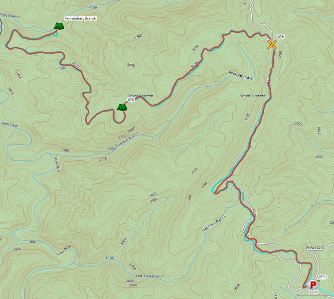
After parking at Dally Gap, we will locate the sign for Hemp Top Trail and begin our 12 mile out and back backpacking trip. We'll hike approximately 2 miles up an old logging road with an elevation gain of about 600 feet. Half way up, we will spot the Benton Mackaye trail intersection. After cresting the ridge at an elevation of 3500 feet, there is about a half mile until the Penitentiary Branch Trail junction. There is a clearly marked sign and fork off to the left. Penitentiary Trail is a 3.6 mile downhill winding trail. We'll drop about 1500 feet and cross the Penitentiary Branch creek at around 1800ft. Penitentiary Branch is not that wide, and should be crossable without removing our shoes unless there have been heavy rains recently. There is a campground located here with a nice fire ring and plenty of flat spots. Upon arrival, we'll set up our tents, eat lunch if we haven't already, and gather wood for our evening fire. Afterwards, we'll walk about a mile to the spectacular Jack's River Falls, hang out, and hike some more down river continuing our exploration. We'll return to camp for dinner, fire, fellowship and camaraderie. The next morning, we may rekindle the fire, have a leisurely breakfast, break camp and hike out around 10:30am or so. This trip is rated a D4 since we may extend the day hike. Also, the hike out on Penitentiary Branch Trail is virtually all uphill for 3.6 miles - you will need to be fit to do this portion of the hike at a moderate pace. Special thanks to Greg Pries (Technical Director, MileStepper), Kristi Edie, and Grant Brown, (AOC TL's), for event info. Here's a trail map:
| |||||||
| |||||||
| How to Get There: | |||||||
| Event Directions: | Take Highway 2, a windy state highway that'll lead into a gravel road. The road is well maintained and should pose no problem for any vehicle. About 2 miles into the gravel, you'll reach an intersection with Cohutta Wilderness signs. You'll want to head to the right on FS-22. This will go for another 2 miles until you reach Dally Gap.
Park at Dally Gap. Locate the sign for Hemp Top Trail. | ||||||
| Carpool to Event Distance (round trip): | 100Mile(s) | ||||||
| Carpool Departure Time: | 8:00 am | ||||||
| Carpool Location: | Log in for location | ||||||
| Carpool Directions: | Log in for directions | ||||||
| Carpool Cost: | Estimated cost per vehicle for this event is $40.00 using a reimbursement rate guideline of $0.400 per mile. The total amount should be divided by the number of people in the vehicle, including the driver. This is a guideline, not a rule, for drivers but the cost should not be higher unless there are extenuating circumstances. | ||||||
| Notes: | |||||||
|
Will this event occur rain or shine? Yes, but not in extremely poor conditions. * We encourage all members to follow our Etiquette Guidelines while participating in AOC events. | |||||||
Cancellation/Partial Attendance: Please review the AOC cancellation policy. | |||||||