Cohutta Mountain Loop - East Cowpen, Hickory Ridge, Beech Bottom & Rough Ridge | |||||||
| The Basics: | |||||||
| Event Type: | Backpacking | ||||||
| Event Location: |
Cohutta Wilderness Area


| ||||||
| Date(s) & Time: | Sat, Sep 13 2014 7:00 am >> Sun, Sep 14 2014 5:00 pm (Carpool Departure: 7:00 am *log in for location*) | ||||||
| Registration Opens: | Mon, Aug 25 2014 8:00 pm | ||||||
| Registration Cut Off: | Fri, Sep 12 2014 6:00 pm | ||||||
| Event Duration: | 1 Days 10 Hours | ||||||
| Difficulty Rating: | D5: Difficult (Exploratory) | ||||||
| Distance: | 16 Miles | ||||||
| Pace: | Moderate | ||||||
| Trip Leader(s): | Mike Pawloski Email Trip Leader(s) Email Trip Leader(s)
You must be logged in to get the Trip Leader contact information. | ||||||
| Member Cost: | None | ||||||
| Participant Info: | |||||||
| Who's Invited: | Members Only, 21 And Older Only | ||||||
| Maximum Group Size: | 10 | ||||||
| Minimum Group Size: | 3 | ||||||
| Number Registered So Far: | 5 / 0 (To see who's signed up, log in to the Member Area) | ||||||
| Are Dogs Permitted: | Yes | ||||||
|
Note: This is an "EXPLORATORY" trip. This means that there are parts of this trip, or perhaps the whole trip, that is new to your Trip Leader(s). However, they are confident that this will not be an issue. This note is here so that you can make an informed decision. When a Trip Leader isn't personally familiar with a trip, there is an increased chance of things not going as planned and you need to be prepared. The Trip Leader may have additional details in the itinerary. | |||||||
| Itinerary: | |||||||
The Cohutta Wilderness covers 36,977 acres (about 60 square miles) that spill over the Georgia/Tennessee border and lie within the 95,265-acre Cohutta Wildlife Management Area. It was designated as a wilderness in 1975. Hemp Top was added in 1986, making this the third largest mountain wilderness area in the East. Please note this particular backpack covers a demanding route. If you have not completed a recent D5 hike/backpack or we have not been on an event previously, expect to have a conversation regarding fitness and capabilities. This loop will traverse four trails - East Cowpen, Hickory Ridge, Beech Bottom and Rough Ridge. The hike in and descent down Hickory Ridge is steep. Once at Beech Bottom. we'll cross the Jack's River twice and then continue along Rough Creek. We will traverse Rough Creek then look to secure our sites for the night. This is where it gets exploratory. I have not stayed at our target camp site, but did hike by there. It looked feasible...and tight. If you are not comfortable being in close quarters or on uneven terrain, this might not be the trip for you. (Protip: A hammock might be a good option.) After set-up we can hike back to Beech Bottom for a swim then hike over to the falls and spend the afternoon swimming and enjoying the area. There are lot's of options and you're free to roam or just hang near camp. The evening will include the fellowship and camaraderie that are hallmarks of AOC events. Departure time from camp will be determined by team consensus. The ascent up and hike out along Rough Ridge Trail is a knee-buster and quad-burner. We will move at a moderate pace and take breaks as needed. In the Notes section below is a map of the route, Concurrent Mapping and Localization (CML) points, an elevation profile, and some trail signage we'll encounter. I've also included a possible back-up camp site should we determine our intended target area is not feasible. Thanks to Kristi Eide for the back-up site information. | |||||||
| |||||||
| How to Get There: | |||||||
| Event Directions: | Three Forks Parking Area Coordinates are 34.8815613, -84.5658722 Directions: From Atlanta, GA: Take I-75 to I-575, and follow I-575 up into North Georgia. I-575 will become Route 515. In Elijay, take a left onto Soule Bridge, and immediately another left onto GA Route 52. In downtown Elijay, take the second exit to the right on the roundabout. Follow GA 52 for 5.2 miles until Gates Chapel Road. Turn right onto Gates Chapel Road and follow it for 5.4 miles. When pavement will end, keep right onto Wilderness Trl. Follow it for 1.5 miles, and then take a right onto Old CCC Camp Road. Follow it for 3.2 miles to the top of the mountain and USFS 64. Turn right onto USFS 64, and follow it for 4.2 miles until you will see a large parking lot on the left of the road, while the road itself sharply switchbacks to the right. This is Dally Gap. | ||||||
| Carpool to Event Distance (round trip): | 150Mile(s) | ||||||
| Carpool Departure Time: | 7:00 am | ||||||
| Carpool Location: | Log in for location | ||||||
| Carpool Directions: | Log in for directions | ||||||
| Carpool Cost: | Estimated cost per vehicle for this event is $60.00 using a reimbursement rate guideline of $0.400 per mile. The total amount should be divided by the number of people in the vehicle, including the driver. This is a guideline, not a rule, for drivers but the cost should not be higher unless there are extenuating circumstances. | ||||||
| Notes: | |||||||
|
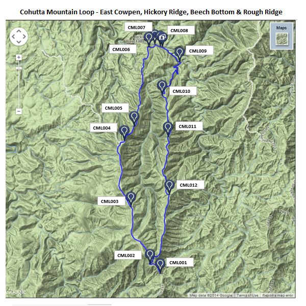
Dotted with place names like Crooked Dog Gap and Rough Creek, this 15.5-mile route mixes rugged ridgeline CML001 Location: 34.8815613, -84.5658722 CML002 Location: 34.8852959, -84.5707321 CML003 Location: 34.9073372, -84.5796661 CML004 Location: 34.9329491, -84.5826797 CML005 Location: 34.9384308, -84.5780411 CML006 Location: 34.9689865, -84.5712128 CML007 Location: 34.9699326, -84.5683899 CampsiteLocation: 34.9689903, -84.5648193 CML008 Location: 34.9693756, -84.5659027 CML009 Location: 34.9631729, -84.556778 CML010 Location: 34.9504128, -84.5650253 CML011 Location: 34.9343452, -84.562294 CML012 Location: 34.9119568, -84.561615
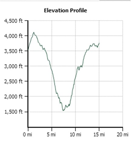
Here's an elevation profile of the hike:
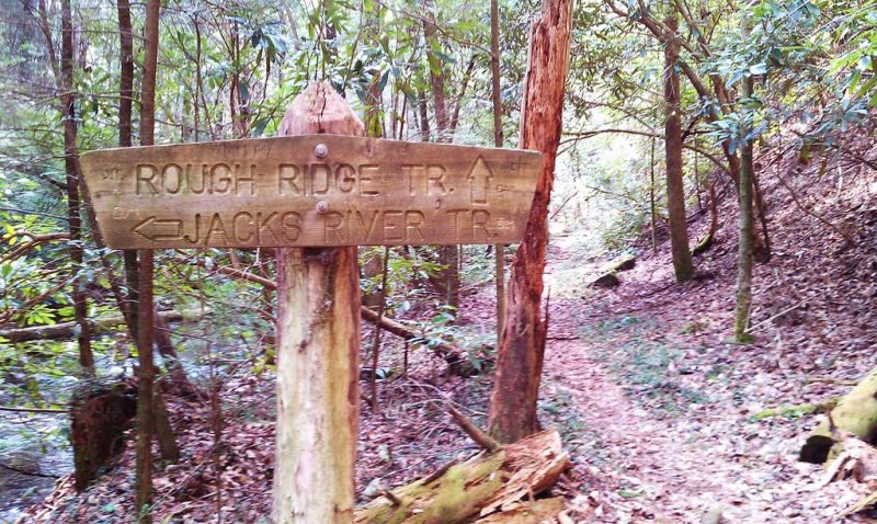
Here's a sign at the intersection of Rough Ridge Trail and Jack's River Trail which we will encounter after our second Jack's River crossing. Just before reaching this sign is a small campsite with room for one or two tents. We will continue towards Rough Ridge Trail from here and traverse Rough Creek in .25 miles. Once on the other side of Rough Creek we will set-up our camp.
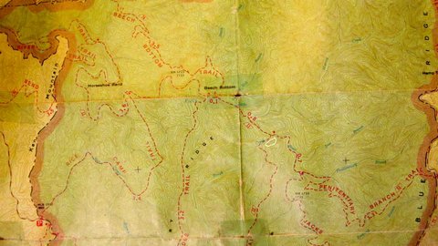
Here's a map to a back-up camp site if we need it. Thanks to Kristi Eide for the information.
The camp area is visible from the Jack's River Trail and is down a slope from the trail. (See white circled area.) If you're hiking north (up river) on the Jack's River Trail, with the Peniteniary Trail behind you, the campsite is down on the left, before crossing the creek.
If you're hiking south towards Peniteniary Trail, you'll cross the creek and the Jack's River Trail starts climbing up a hill; you should see the campsite on the right... there is a little trail going towards it.
* We encourage all members to follow our Etiquette Guidelines while participating in AOC events. | |||||||
Cancellation/Partial Attendance: Please review the AOC cancellation policy. | |||||||