Chasing Shimmers on Sapphire Lakes - North Cascades | |||||||
| The Basics: | |||||||
| Event Type: | Adventure | ||||||
| Event Location: |
Concrete, Washington


| ||||||
| Date(s) & Time: | Sat, Aug 15 2026 6:00 am >> Sat, Aug 22 2026 6:00 pm | ||||||
| Registration Opens: | Tue, Nov 25 2025 7:00 pm | ||||||
| Registration Cut Off: | Sun, Nov 30 2025 5:00 pm | ||||||
| Event Duration: | 7 Days 12 Hours | ||||||
| Difficulty Rating: | D6: Advanced (Exploratory) | ||||||
| Pace: | Moderate | ||||||
| Trip Leader(s): | Deema Email Trip Leader(s) Email Trip Leader(s)
You must be logged in to get the Trip Leader contact information. | ||||||
| Member Cost: | $25.00/Person (See Detailed Cost Info Below) | ||||||
| Participant Info: | |||||||
| Who's Invited: | Members Only, 21 And Older Only | ||||||
| Maximum Group Size: | 1 | ||||||
| Minimum Group Size: | 1 | ||||||
| Number Registered So Far: | 13 / 4 (To see who's signed up, log in to the Member Area) | ||||||
| Are Dogs Permitted: | No | ||||||
|
Note: This is an "EXPLORATORY" trip. This means that there are parts of this trip, or perhaps the whole trip, that is new to your Trip Leader(s). However, they are confident that this will not be an issue. This note is here so that you can make an informed decision. When a Trip Leader isn't personally familiar with a trip, there is an increased chance of things not going as planned and you need to be prepared. The Trip Leader may have additional details in the itinerary. | |||||||
| Itinerary: | |||||||
Highlights - Alpine scenery: Expect to see dramatic, rugged peaks - Glaciers: The largest concentration of glaciers in the contiguous U.S. outside of Alaska - Remote experience: a relatively uncrowded park, allows for better wild experience
Climate - North Cascades sunrise times in mid-August generally around 6am, sunset is as late as 9pm. - August is the hottest month with temp averages 72 °F high, 55 °F low.
Game Plan Sat 15th Travel Day - Meeting in Seattle airport by 1:30pm the latest - Drive over 2 hours to our residence, around 100miles - Stop at a major grocery store on the way - Arrive to residence - Get in the zone: A scenic stop at Hurn Field https://maps.app.goo.gl/HXjJyGi45fwNkdfS7 and/or: Short walk at Rasar State Park https://maps.app.goo.gl/k5Cd31Ljta6L5X2Z7
Sun 16th "The kickstart" Hike 1 – D4 The Heather-Maple Pass Loop Trail Trail Length: 7.2 miles Elevation Gain: 2,020 feet Driving Directions: https://maps.app.goo.gl/SDvjoqb9k1kGqPgJ7 AllTrails Link: maple-pass-trail The hike has lots of greenery and wildflowers blanketing the hillsides. By hiking clockwise, we start with an unrelenting climb up switchbacks, climbing the entire 2,200 feet of elevation gain over 2.3 miles. Then, it’s a long, gradual descent back down to the trailhead. We will take the offshoot trail to the right to the shore of Lake Ann. The hike starts on US Forest Service land, not inside the national park, Northwest Forest Pass needed for parking.
Mon 17th "The Big Bang" Hike 2 – D6 The Cascade Pass / Doubtful Lake / Sahale Arm Trail Trail Length: 13.0 miles Elevation Gain: 4,600 feet Trail Type: Out and Back Driving directions (1:20): https://maps.app.goo.gl/SgfBpjpgwwwtLfU36 AllTrails Link: The Cascade Pass / Doubtful Lake / Sahale Arm Trail Absolutely one of the best hikes in the North Cascades that perfectly encapsulates what makes this part of the world special. This is actually 2 hikes + a bonus excursion to the lake: first is the initial climb to Cascade Pass, followed by one mile round trip to the lake, then we climb to the base of the Sahale Glacier. The trailhead is at the end of a 23-mile gravel road – called Cascade River Road. No warm up, we will get right into a steep 2.5 miles section of tight switchbacks up a rocky hillside (where we will find our marmot friends squeaking!). Steady climb, nice scenery, and wildflowers will surround the trail. We will start to get some nice views when we approach the top of the switchbacks, and things really start to get good when we arrive at the ridgeline and start the final push to the pass (which is about another mile). We leave the pass heading towards the glacier, the trail gets both noticeably steeper and noticeably more beautiful. It climbs through subalpine meadows that turn into a rocky ridge, ending with a steep rocky climb through a boulder field to Sahale Glacier Camp. Must have: Hiking poles, plenty of layers, sun protection, and microspikes “just in case”.
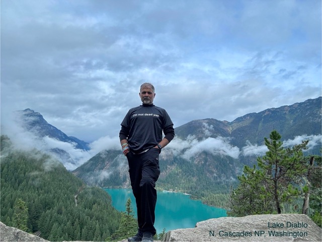
Tue 18th "Strategic Blasé" Hike 3 OPTIONAL – D3 The Blue Lake: 5 miles out and back, Elevation Gain: 1,050 feet. The best easy hike in Washington State because the reward-to-effort ratio is really, really high. Driving Directions: https://maps.app.goo.gl/ArTqjwkU8wKZrpRn9 AllTrails Map: blue-lake-trail After a short, gradual climb through the forest (with occasional breaks in the trees to see the peaks that climbers are often ascending), we emerge onto the shore of a gorgeous alpine lake backed by those beautiful peaks. When the sun hits the lake, it shimmers and turns a spectacular bright blue-green color. Hopefully, we get to see wildlife, including the elusive mountain goats that hang out on the scree. But first: Breakfast / Brunch: Maybe we try the famed (dedicated gluten free bakery): https://5bsbakery.com/menu.html Scenic drive on the North Cascades Highway, multiple stops options for short walks and overlooks: - The Visitor Center - Ladder Creek Falls, 0.5 miles, 360 feet. AllTrails Link: ladder-creek-falls We will cross the river on the suspension bridge to reach the paved path. A short but sweet venture into the forest through Ladder Creek Gardens, blooming with wild flora. Close-up views of the cascading falls. The mist rising from the falls is a perfect remedy for hot days. - Gorge Dam Viewpoint - Ross Lake Overview - Ross Dam Trailhead - Diablo Lake Vista Point: striking turquoise waters, colored by glacial "rock flour".
Wed 19th "The Pacific Crest Trail" Hike 4 – D5(ish) Cutthroat Pass via PCT Trail Length: 12 miles (AT is not correct) Elevation Gain: 2,200 feet AllTrails Link: Cutthroat Pass via PCT Driving directions (1:30): https://maps.app.goo.gl/SA2yshvEgG78dobe8 It would be foolish of me to attempt to give this hike a title! The trail begins at the Rainy Pass Trailhead, with a relatively gentle initial section through lush forests. Around 2 miles into the hike, we’ll encounter a series of switchbacks leading us through alpine meadows decked with wildflowers. This section also offers excellent opportunities for spotting wildlife like marmots, pikas, and occasionally, black bears. About 3.7 miles into the hike, we’ll reach a viewpoint for stunning vistas of the North Cascades. The final push to Cutthroat Pass involves a steeper climb, gaining about 1,000 feet in elevation over the last 1.2 miles. The terrain becomes more rugged, and the vegetation transitions to hardy alpine species. The pass itself sits at an elevation of approximately 7,000 feet and offers breathtaking views of the surrounding peaks and valleys. Happy Hour at Washington Pass Overlook: A short walk to see Liberty Bell Peak and Early Winters Spires.
Thu 20th "The Perfect Strike" Hike 5 – D5 Chain Lakes Loop Trail & Table Mountain (adjustable to do 9 miles D4) Trail Length: 11 miles Elevation Gain: 2,700 feet Driving Directions: https://maps.app.goo.gl/qq4JqGq1FhpRhcVQ8 AllTrails Map: Chain Lakes Loop / Table Mountain This hike is a perfect strike because we’ll visit ten beautiful sites. We’ll park by Sunrise Lake, head south on Bagley Dam, and the trail passes between Iceberg Lake and Hayes Lake. We’ll cross Mazama Lake and then divert from the lakes for a 3-mile round trip to reach Table Mountain. When we return to the loop, we’ll reach Artist Point and hike north, passing by Terminal Lake and Austin Pass. Finally, we’ll loop around Heather Meadows Visitor Center.
Fri 21st "Out with a splash" Hike 6 – D5 The Park Butte Lookout Trail Trail Length: 9 miles Elevation Gain: 2,450 feet Trail Type: Out and Back with creek crossings Must have: hiking poles & water shoes for possibly rapid water crossings AllTrails Link: park-butte-lookout Driving directions: https://maps.app.goo.gl/wLXtoF7wYZY9aM748 This hike is actually near Baker Lake, outside the park boundaries on the western side, the payoff at the end of this hike is a spectacular view of Mount Baker’s southern face, with blankets of blooming wildflowers in the summertime. The trailhead is at the end of a nine-mile gravel and dirt road that is a little bumpy in places. The trailhead (this is where you start the climb to Mount Baker’s summit from the southern side) is really nice. The trail climbs gently at first, crossing a creek and winding through the forest. Then you hit a series of switchbacks that climb aggressively for about a mile before you’re dumped into a wide-open meadow, blanketed with lupine and other wildflowers, which is where the views of Mount Baker begin to materialize. Then the terrain turns rocky. The views of Baker are nothing short of spectacular basically the entire way through. The end point of the hike is a fire lookout that looks north at Mount Baker.
Sat 22nd Travel Day Drive over 2 hours to airport, around 100miles.
Accommodations - Beautiful location, short walk to Rasar State Park on Skagit River - 37909 Theo Lane, Concrete, WA 98237, https://www.booking.com/Share-TaQrrY - 4bd, 3ba, spacious kitchen, hot tub, fire pit, foosball table, NO AC
Food - Grocery: I plan on stopping at a major grocery store on our way out of Seattle, please buy enough supplies to last a week, but we will have access to “Concrete Market Fresh” and a couple small gas stations stores. - Dinner: We will primarily rely on dining out.
Communiqué - WhatsApp group text messaging to share information and pictures. - AllTrails links are in the write-up, please be prepared before getting out of the door. - Google Maps is our tool for driving directions.
Open Positions We will share all responsibilities: - Keeping the house in manageable condition: 2 positions - Driving to trailheads: 3 additional drivers needed - Research Guru: Monitor weather and fires conditions
- Grocery shopping / Fuel Up
Logistics We will meet in Seattle Airport no later than 2pm on Saturday Aug 15th, and will return to the airport on Saturday Aug 22nd. If you have other plans, please discuss with trip leader in advance. All trailheads (except for one) are 60-90 minutes away, 2 drivers will be assigned to each car so we can share the workload.
C'est la vie Travel presents unforeseen circumstances, necessitating adjustments to itinerary based on flights schedule, weather, unforeseen, and natural events. The group will need to adapt to any challenges that arise with flexibility and a positive outlook. We have a solid plan, but sometimes, things happen, bring an open mind and a fun spirit, that's all we need for an amazing time.
| |||||||
| |||||||
| Notes: | |||||||
|
Make a well-considered choice Although I am known for my brisk hiking pace, I intend to fully appreciate the breathtaking scenery and seize every opportunity to immerse myself in the calming ambiance. Each trailhead, except for one, is situated between 60-90 minutes from our residence. The drive is lengthy, but the limited infrastructure is a consequence of the park’s primary objective of preserving its natural, undeveloped state.
Joining The Event In building this group, I will emphasize ability, team work, and compatibility. Physical fitness assessment is subject to my personal experience, not only AOC credentials. An essential aspect of the selection process is to ensure the utmost comfort of the participants within the residence. In addition, an important quality is collaborative efforts and the willingness to be an active participant, we’ll need, at minimum, two drivers for each car to spread the workload.
Please sign up for this event if all of the following statements apply to you: - I’m excited to participate in all the planned activities. - I’m happy to take on most of the tasks listed under “Open Positions”. - I carefully considered the schedule and hiking trails. I am confident that the itinerary doesn’t exceed my physical limits. - I’m sensible enough to avoid getting close to that elusive mountain goat.
Photos of Diablo Lake are courtesy of AOC trip leader Kiran Important information for paid events in which payment is managed through the AOC: - Payment must be received by the payment due date and prior to participation in the event. - Some paid events require a minimum number of registered participants. If that number is not met, the event will be canceled and refunds will be issued to those who have already paid. - Third-party vendors often require damage deposits. Each registrant agrees to be liable for and required to reimburse the Atlanta Outdoor Club for any withheld deposits due to the actions of or damages caused by that registrant. - No partial payments. All registrants must pay the posted Member Cost regardless of any agreement you may have with any party involved in the event. - Read the event description carefully for additional information, and contact the trip leader(s) with any questions. * We encourage all members to follow our Etiquette Guidelines while participating in AOC events. | |||||||
| Cost & Payment: | |||||||
| Member Cost: | $25.00/Person | ||||||
| Cost Includes: |
AOC fee to be paid via PayPal: $25 AOC fee (Nonrefundable)
Trip cost based on 8 attendees is $985 to be paid to trip leader directly via Zelle or Venmo. Deadline: November 30th, 5pm. Includes: Accommodations, Car rental and insurance, Gas.
Cost Fine Print o AOC fee is nonrefundable o All other costs are refundable if and only we have somebody suitable to take your spot. o Lodging cost is shared equally regardless of sleeping arrangements. o The car rental and gas cost for each individual will be their proportional share. This cost may increase if there are fewer than four people per car or if gas prices significantly changes. o The cost is refundable only if the TL can find a suitable replacement. o Express toll lanes, bridges and tunnels fees are not included. o Gas allowance is included o Parking permits are not included. o Food and household items costs are not included. | ||||||
| Payment Cut Off: | Payment must be received by the AOC on Sun, Nov 30 2025. | ||||||
| Make a Payment: | Click here for the details. PLEASE PAY AFTER YOU HAVE SIGNED UP BELOW. | ||||||
Cancellation/Partial Attendance: Please review the AOC cancellation policy. | |||||||