 Print-Friendly Version Print-Friendly Version
|
|
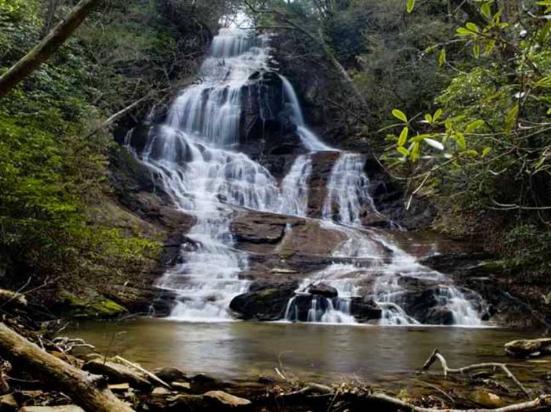
Falls Creek Falls (GA, not TN) | |||||||
| The Basics: | |||||||
| Event Type: | Hike | ||||||
| Event Location: |
Wildcat Tract, Dawson Forest


| ||||||
| Date(s) & Time: | Sun, Mar 29 2015 11:15 am >> Sun, Mar 29 2015 2:45 pm (Carpool Departure: 10:00 am *log in for location*) | ||||||
| Registration Opens: | Wed, Mar 25 2015 6:00 pm | ||||||
| Registration Cut Off: | Sat, Mar 28 2015 11:00 pm | ||||||
| Event Duration: | 3 Hours 30 Minutes | ||||||
| Difficulty Rating: | D3: Moderate | ||||||
| Distance: | 5 Miles | ||||||
| Pace: | Moderate | ||||||
| Trip Leader(s): | John Weatherman Email Trip Leader(s) Email Trip Leader(s)
You must be logged in to get the Trip Leader contact information. | ||||||
| Member Cost: | None | ||||||
| Participant Info: | |||||||
| Who's Invited: | Members Only, 21 And Older Only | ||||||
| Maximum Group Size: | 16 | ||||||
| Minimum Group Size: | 6 | ||||||
| Number Registered So Far: | 14 / 0 (To see who's signed up, log in to the Member Area) | ||||||
| Are Dogs Permitted: | Yes | ||||||
| Itinerary: | |||||||
Thanks to Gordon S for suggesting someone post this. This is a five mile loop hike in the Wildcat Creek Tract of Dawson Forest with nearly 1500 feet in elevation gain. The main feature is a 75 + ft waterfall called Falls Creek Falls, but it also has a scenic stream and good winter views. If this hike had any more elevation gain it would be a D-4, but we are keeping it a D-3 so it will be accessible to less advanced hikers. If you are a fast hiker, and you don’t like to wait for slower people, this is not going to be the hike for you. That said, the last part is strenuous, and you will need to be able to handle it, even if slowly. We start out at our loop at the high point and go down and come back up. The last third of the hike, after we have stopped at the falls, is very steep. Slower people can take their time, and we will make sure you get back to the top. We start out following a gated gravel road along a ridge for just over a mile. Then the trail leads downhill for about a mile, steeply at times, to Falls Creek, where we turn upstream. We follow the stream up for a mile or so where we reach a short side trail that will take us to the bottom of the falls, where we can have lunch. From there, it is about two miles back to the trailhead. Some of these sections are very steep, as we have to make up the elevation we lost coming down. There are a couple of places where the trail crosses Falls Creek which we may have to ford, depending on water levels. You may have to take your shoes off to cross, so you need to bring flip flops or some other type of water shoe unless you want to do it barefoot. DNR requires a GORP pass or a hunting or fishing license to enter this section. We plan to get enough group GORP passes for the size of the group. The passes cost $12.50 per eight people, so unless you already have a pass or license, plan to reimburse your pass holder a dollar or two, like you would pay your driver for gas. | |||||||
| |||||||
| How to Get There: | |||||||
| Event Directions: | Take a right out of the Park and Ride and an immediate left onto Busbee Parkway. Go a half mile to Chastain Rd and take a right. In another half mile take a left onto 575 North. Go north 35 miles on 575 to GA 53 (W Church St) and take a right. You will be in Jasper. Go 1.8 miles through downtown Jasper and take a left onto Burnt Mountain Rd, GA 108. GA 108 will join GA 136. Stay on GA 136/GA 108 going east. After about 12 miles GA 108 turns left, but you stay on GA 136 for a few hundred yards and Monument Rd will be on your right at the ridge top on the Pickens/Dawson line. The trailhead is on Monument Rd about three miles on the left. After you pass the Monument Falls II subdivision on the right, the road will narrow but stay asphalt. The trailhead will not be far from there. It will be a little parking lot with a sign. The coordinates are N 34 30.43, E 84 20.13. An approximate address is 4644 Monument Rd, Jasper GA 30143. | ||||||
| Carpool to Event Distance (round trip): | 104Mile(s) | ||||||
| Carpool Departure Time: | 10:00 am | ||||||
| Carpool Location: | Log in for location | ||||||
| Carpool Directions: | Log in for directions | ||||||
| Carpool Cost: | Estimated cost per vehicle for this event is $41.60 using a reimbursement rate guideline of $0.400 per mile. The total amount should be divided by the number of people in the vehicle, including the driver. This is a guideline, not a rule, for drivers but the cost should not be higher unless there are extenuating circumstances. | ||||||
| Notes: | |||||||
|
* We encourage all members to follow our Etiquette Guidelines while participating in AOC events. | |||||||
Cancellation/Partial Attendance: Please review the AOC cancellation policy. | |||||||
 Calendar of Events
 Event Places