 Print-Friendly Version Print-Friendly Version
|
|
Cohutta Wilderness Grand Tour | |||||||
| The Basics: | |||||||
| Event Type: | Backpacking | ||||||
| Event Location: |
Cohutta Wilderness


| ||||||
| Date(s) & Time: | Sat, Apr 11 2015 8:00 am >> Sun, Apr 12 2015 10:00 pm (Carpool Departure: 6:20 am *log in for location*) | ||||||
| Registration Opens: | Thu, Mar 26 2015 8:00 pm | ||||||
| Registration Cut Off: | Fri, Apr 10 2015 8:00 pm | ||||||
| Event Duration: | 1 Days 14 Hours | ||||||
| Difficulty Rating: | D7: Extreme | ||||||
| Distance: | 48 Miles | ||||||
| Pace: | Fast | ||||||
| Trip Leader(s): | Eric P Jane  Email Trip Leader(s) Email Trip Leader(s)
You must be logged in to get the Trip Leader contact information. | ||||||
| Member Cost: | None | ||||||
| Participant Info: | |||||||
| Who's Invited: | Members Only, 21 And Older Only | ||||||
| Maximum Group Size: | 8 | ||||||
| Minimum Group Size: | 2 | ||||||
| Number Registered So Far: | 4 / 0 (To see who's signed up, log in to the Member Area) | ||||||
| Are Dogs Permitted: | No | ||||||
| Itinerary: | |||||||
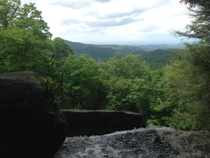
This backpacking trip hits all of the main areas the Cohuttas have to offer over roughly 48 miles. That is to say there will be 50+ water crossings, 2 waterfalls, mountain views, and a couple monster hills. If that sounds like a good time this might be the perfect hike for you. With that being said this is definitely not a trip for beginners and I may contact you if you do not have several other recent D6 backpacking trips. We will be using the Tearbritches, Hickory Creek, Rice Camp, Jacks River, Penitentiary Branch, Hemptop, Benton Mackaye, Rough Ridge, East Cowpen, Panther Creek, Conasauga River, and Chestnut Lead Trails. We will begin the day at the Chestnut Lead Trail head and walk roughly 1.5 miles up the the gravel road to the Tearbritches trail head. From there we will start making our way around the wilderness in a clockwise "loop" after doing it both directions I feel that this is the easier direction going down both Tearbritches and Panther Creek trails. There are over 50 river and creek crossing on this trip ranging from ankle to waist deep depending on the amount of rain recently received. You will get wet repeatedly. Additionally while there are quite a few fairly level sections of trail the up hills that we will encounter will be very steep and strenous. *Most people really like the added balance offered by hiking poles so they are recommend but not required. I will not have them on me but that definitely doesn't mean that is the right choice for everyone. Additionally you will need footwear that you can hike in while they are wet. We will not be stopping at every river crossing to change/remove shoes. I like my trail runners but many people like to have water shoes such as keens or tevas.
Car pool note: The last 9 or so miles to the trailhead are down gravel roads. The roads are in good shape and cars should have no problem making it but it would probably be easier if people with people with SUVs or Trucks were willing to drive. Map of the route seen below. Please note that this is simply traced on the map and not an actual GPS track. From experience the actual mileage tends to be about 10% more than shown below.
| |||||||
| |||||||
| How to Get There: | |||||||
| Event Directions: | |||||||
| Carpool to Event Distance (round trip): | 144Mile(s) | ||||||
| Carpool Departure Time: | 6:20 am | ||||||
| Carpool Location: | Log in for location | ||||||
| Carpool Directions: | Log in for directions | ||||||
| Carpool Cost: | Estimated cost per vehicle for this event is $57.60 using a reimbursement rate guideline of $0.400 per mile. The total amount should be divided by the number of people in the vehicle, including the driver. This is a guideline, not a rule, for drivers but the cost should not be higher unless there are extenuating circumstances. | ||||||
| Notes: | |||||||
|
* We encourage all members to follow our Etiquette Guidelines while participating in AOC events. | |||||||
Cancellation/Partial Attendance: Please review the AOC cancellation policy. | |||||||
 Calendar of Events
 Event Places