Unicoi Gap To Brasstown Bald (and back)
|
|
The Basics: |
| Event Type: |  | Hike | |
|
Event Location: | |
Unicoi Gap


| |
| Date(s) & Time: | | Sun, May 3 2015
9:30 am >> Sun, May 3 2015 8:00 pm (Carpool Departure: 8:00 am *log in for location*)
| |
| Registration Opens:
| |
Thu, Apr 30 2015 4:00 am
| |
| Registration Cut Off:
| |
Sun, May 3 2015 7:00 am
| |
| Event Duration: | | 10 Hours 30 Minutes | |
| Difficulty Rating: | | D6: Advanced (Exploratory) | |
| Distance: | | 20 Miles | |
| Pace: | | Moderate | |
Trip Leader(s):
| | Ron S
 Email Trip Leader(s) Email Trip Leader(s)
You must be logged in to get the Trip Leader contact information.
| |
| Member Cost: | | None |
|
| Participant Info: |
| Who's Invited: | |
Members Only, 21 And Older Only
| |
| Maximum Group Size: | | 12 |
| Minimum Group Size: | | 2 |
| Number Registered So Far: | |
7 / 0 (To see who's signed up, log in to the Member Area)
|
| Are Dogs Permitted: | |
No
|
|
Note: This is an "EXPLORATORY" trip. This means that there are parts of this trip, or perhaps the whole trip, that is new to your Trip Leader(s). However, they are confident that this will not be an issue.
This note is here so that you can make an informed decision. When a Trip Leader isn't personally familiar with a trip, there is an increased chance of things not going as planned and you need to be prepared. The Trip Leader may have additional details in the itinerary.
|
| Itinerary: |
I copied some of this from a trip in 2009 that looked like a real challenge. Our objective is to hike from Unicoi Gap to Brasstown Bald for excellent views from the highest place in GA, then hike back for a distance of ~ 20 miles. I plan to stop briefly on the way up to touch the alleged source of the mighty Chattahooche river. Woohoo! What a high day it will be!
Summary (all in one place):
- leave the carpool at 8:00 am
- take a quick bathroom break if needed in Helen
- leave the unicoi gap trailhead at 9:30 am
- eat lunch on brasstown bald
- refill water at brasstown bald
- hike back the same way
- arrive at the cars before dark (dark would be around 8:00 pm)
- hiking time no more than 10.5 hours
- that means we must get to the top in less than 5 hours (2 mph) to have time for lunch and the hike back.
- drive back to the carpool, arriving no later than 9:30 pm.
- hopefully we will be a bit faster than this worst case scenario.
- we may have dinner on the way home if there is a sub-group that really wants to, but I suspect most will want to just get home, get a shower and get in bed :-)
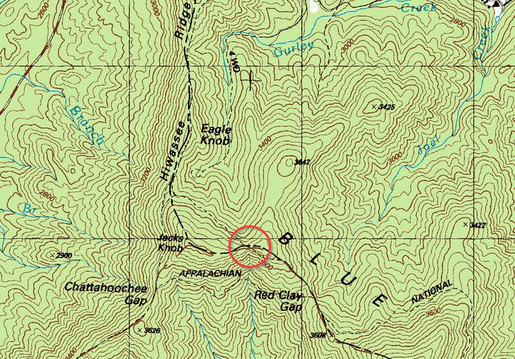
We'll make a small side trip on the way to see the source of the Chattahoochee river. The red circle on the picture above is where I think it is. I have not done this hike before so we'll make sure to check every intersection.
Below is mostly quoted from Danny Llewallyn's itinerary a few years ago. Hopefuly not much has changed (except that now this hike is classified as D6)!
=-=-=-=-=-=-=-=-=
We will start at Unicoi Gap and hike approx 4.4 miles on the AT (Appalachian Trail) to Chattahoochee Gap. From Chattahoochee Gap we will turn north (hang a right) leaving the AT and onto the Jacks Knob Trail. This will take us 4.5 miles to the Brasstown Bald parking lot and will involve approx. 2000 feet of total ascent.
From the parking lot, we will take the Brasstown Bald paved trail .6 miles and 400 feet up to the summit and the observation platform which will hopefully give us great views if the weather cooperates. We'll have lunch here while viewing how far we have come and how far we have yet to go.
After lunch, we will return the same way we came.
We can refill our water at Brasstown Bald and/or at Chattahoochee Gap (trip leader will bring a filter). Also, if you have never seen the spring at Chattahoochee Gap, you have to check it out. Just .15 mi/160 feet down from the Gap, which is little more than a trickle of water at 3200 feet, this spring is widely regarded as the origin/headwaters of the Chattahoochee River. I'm amazed each time I go down to see it - I wonder why I did it.
We'll decide as a group whether or not we will stop for dinner on the way home. Most of us may be needing to hit the sack soon after the hike though, but we'll see how everyone feels then.
Recap:
Unicoi Gap to Chattahoochee Gap - 4.4 miles, ~1600 feet total ascent
Chattahoochee Gap to Brasstown Bald parking- 4.5 miles, ~2000 feet total ascent
Brasstown Bald trail .6 miles to Brasstown Bald -.6 miles, ~400 feet ascent
Brasstown Bald to Brasstown Bald parking lot - .6 miles
Brasstown Bald parking lot to Chattahoochee Gap- 4.5 miles, ~1000 feet total ascent
Chattahoochee Gap to Unicoi Gap - 4.4 miles, ~900 feet total ascent
Total: ~20 miles, ~6000 feet of ascent
This is a strenuous hike and only for advanced hikers with recent experience of hiking 15 or more miles in the mountains. We will be trying to maintain at least a 3 mph pace while hiking and a 2.5 mph average distance rate overall (taking into account the infrequent and brief rest breaks and a lunch break). However, it should all be well worth it and should prove to be an adventurous day on the trail for those who are up to the challenge and would like to join us... |
|
Required Items to Bring:
A hearty breakfast in your belly
At least 2 liters of water
Snacks/lunch (extremely tough hike so bring lots of food)
Hiking boots/shoes
Headlamp in case the sun sets prior to return to Unicoi Gap
Emergency rain gear (even if it is clear day with a 20 percent chance of rain) | | Recommended Items to Bring:
Use our Event Checklists to make sure you have everything you need.
Trekking poles
Extra change of socks to change into at the half-way point
Ibuprofen for the pain
Camera
Change of shoes and shirt for drive back
Water filter (I will bring mine) | |
|
| How to Get There: |
| Event Directions: | | The trailhead parking lot is on GA hwy 75 "Unicoi Turnpike" about 9 miles north of Helen GA. The appalachian trail crosses the highway there and the parking lot is on the right (if you are going north).
The GPS coordinates for the trailhead is 34.801978, -83.742724.
We should arrive there no later than 9:30 am to start hiking, so if you want to meet us there, please be on time since we can't wait. | |
| Carpool to Event Distance (round trip): | | 140Mile(s) |
| Carpool Departure Time: | |
8:00 am
|
| Carpool Location: | |
Log in for location
|
| Carpool Directions: | |
Log in for directions
|
| Carpool Cost: | |
Estimated cost per vehicle for this event is $56.00 using a reimbursement rate guideline of $0.400 per mile. The total amount should be divided by the number of people in the vehicle, including the driver. This is a guideline, not a rule, for drivers but the cost should not be higher unless there are extenuating circumstances.
|
|
| Notes: |
|
Unless the forecast is just plain miserable, this event will go on.
|
|
Cancellation/Partial Attendance: Please review the AOC cancellation policy. |
 Print-Friendly Version
 Calendar of Events
 Event Places