
 Print-Friendly Version Print-Friendly Version
|
|
Brasstown Bald, up Arkaquah Trail, down Wagon Train Trail | |||||||
| The Basics: | |||||||
| Event Type: | Hike | ||||||
| Event Location: | Near Young Harris GA | ||||||
| Date(s) & Time: | Sun, Aug 31 2008 10:00 am >> N/A (Carpool Departure: 8:00 am *log in for location*) | ||||||
| Registration Opens: | Wed, Apr 16 2008 12:00 am | ||||||
| Registration Cut Off: | Sat, Aug 30 2008 5:55 pm | ||||||
| Event Duration: | Twelve hours, seven and a half hours hiking, four and a half hours driving | ||||||
| Difficulty Rating: | D5: Difficult | ||||||
| Trip Leader(s): | John Weatherman Email Trip Leader(s) Email Trip Leader(s)
You must be logged in to get the Trip Leader contact information. | ||||||
| Member Cost: | None | ||||||
| Participant Info: | |||||||
| Who's Invited: | Members Only, 21 And Older Only | ||||||
| Maximum Group Size: | 20 | ||||||
| Minimum Group Size: | 4 | ||||||
| Number Registered So Far: | 16 / 0 (To see who's signed up, log in to the Member Area) | ||||||
| Are Dogs Permitted: | No | ||||||
| Itinerary: | |||||||
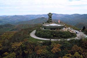
| This is a 13.2 mile strenuous hike. Do not attempt this hike unless you have successfully completed a long hike in the past with a lot of elevation gain. This Labor Day weekend hike is a good way to close the civic summer season of 2008. This is a car shuttle hike that will allow us to climb the highest peak in Georgia by going up one ridge and down a different one. We start at 2280 feet, go up and down 6.1 miles to 4784 feet, and back down 7.1 miles, thus climbing from one climate zone to another. We will start at Track Rock Gap and climb up via the Arkaquah Trail. This trail is notorious for its long steep initial climb to gain the ridgetop. This is a 1350 foot climb in 1.7 miles. We then follow the ridge as it undulates up and down but ever upward to the top of Brasstown Bald. There are great views along the way with some light scrambling in one spot. Once we get to the parking lot at the top we will take the half mile paved trail to the summit along with the tourists who drive up. There is a museum and a 360-degree observation deck at the top at 4,784 feet. If it is clear, we will be able to see four states. The museum has exhibits depicting area wildlife, the lives of the Indians and the early pioneers, as well as the logging of the area. It includes two robotic rangers and a short film about the mountain. There are live rangers on hand also, as well as a gift shop that sells apple cider, among other things. From there we will make our way down to Young Harris via the Wagon Train Trail. This trail was built by convict labor and is longer and not as undulating as the way up was, so it will be easier on our knees. We will be able to look across and see the ridge we came up on as we go down. At the end we will emerge from the woods onto the campus of Young Harris College. Please Note: | |||||||
| |||||||
| How to Get There: | |||||||
| Event Directions: | Directions to Track Rock Gap (Arkaquah Trailhead)
Take 575 going north. Follow this all the way thru Jasper, Ellijay, Blue Ridge and Blairsville. The road designation will change as you go, being variously, I-575, GA-5, GA-515, GA-2 and US 76. Regardless of that, just stay on it, and follow the signs to Blairsville. About six miles past Blairsville, turn right onto Track Rock Gap Rd. Take this about two miles to the high point on the road. This is Track Rock Gap. The trailhead parking is on the right. It is also parking for the Track Rock Gap Archeological Area, and there should be signs for that. Directions from Track Rock Gap to Young Harris College (Wagon Train Trailhead) Go back north about two miles on Track Rock Gap Road, back to US 76, and go right (east). Young Harris will be about two miles. Take a right on Bald Mountain Road, just before the Sharp Memorial United Methodist Church. Go about two tenths of a mile to a fork behind the Appleby Center on the campus of Young Harris College, and park in one of the lots there. The trailhead is the gated dirt road past that. | ||||||
| Carpool to Event Distance (round trip): | 202Mile(s) | ||||||
| Carpool Departure Time: | 8:00 am | ||||||
| Carpool Location: | Log in for location | ||||||
| Carpool Directions: | Log in for directions | ||||||
| Carpool Cost: | Estimated cost per vehicle for this event is $80.80 using a reimbursement rate guideline of $0.400 per mile. The total amount should be divided by the number of people in the vehicle, including the driver. This is a guideline, not a rule, for drivers but the cost should not be higher unless there are extenuating circumstances. | ||||||
| Notes: | |||||||
|
* We encourage all members to follow our Etiquette Guidelines while participating in AOC events. | |||||||
| Cost Includes: | Please share gas expenses with carpool drivers. | ||||||
Cancellation/Partial Attendance: Please review the AOC cancellation policy. | |||||||
 Calendar of Events
 Event Places