 Print-Friendly Version Print-Friendly Version
|
|
Siler Bald & Wayah Bald on the AT | |||||||
| The Basics: | |||||||
| Event Type: | Hike | ||||||
| Event Location: |
west of Franklin, NC


| ||||||
| Date(s) & Time: | Sat, Aug 15 2015 8:00 am >> Sat, Aug 15 2015 7:30 pm (Carpool Departure: 8:00 am *log in for location*) | ||||||
| Registration Opens: | Tue, Aug 11 2015 9:00 pm | ||||||
| Registration Cut Off: | Fri, Aug 14 2015 12:00 pm | ||||||
| Event Duration: | 11 Hours 30 Minutes | ||||||
| Difficulty Rating: | D5: Difficult | ||||||
| Distance: | 12 Miles | ||||||
| Pace: | Moderate | ||||||
| Trip Leader(s): | Jared S Dorothea  Email Trip Leader(s) Email Trip Leader(s)
You must be logged in to get the Trip Leader contact information. | ||||||
| Member Cost: | None | ||||||
| Participant Info: | |||||||
| Who's Invited: | Members Only, 21 And Older Only | ||||||
| Maximum Group Size: | 12 | ||||||
| Minimum Group Size: | 2 | ||||||
| Number Registered So Far: | 7 / 0 (To see who's signed up, log in to the Member Area) | ||||||
| Are Dogs Permitted: | Yes | ||||||
| Itinerary: | |||||||
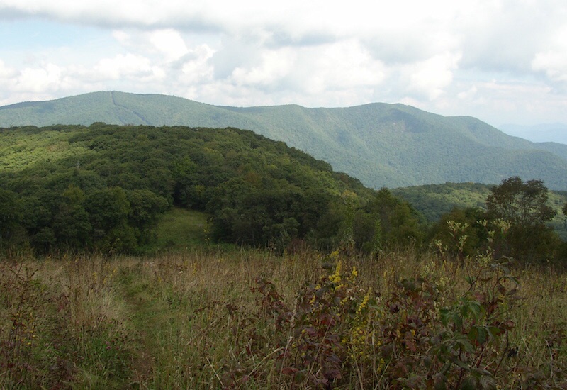
Here we have two magnificent views on a figure-8 hike. The center of the figure 8 is the parking lot at Wayah Gap (~4200 ft). To make the first loop we ascend Siler Bald (5216 ft), where we will enjoy a 360-degree view on a wide-open grassy crown, after which we return to Wayah Gap (4 miles, 2 hours). For the second loop we cross the road and ascend Winespring Mountain and continue along the ridge to Wayah Bald (5350 ft), where we enjoy another almost 360-degree view from the recently restored fire tower, before returning to Wayah Gap (8 miles, 4 hours). Total elevation gain about 3000 ft. Two details of the hike: we will remain on the top of Siler Bald for 30 minutes to take in the awesome view or to take photos or eat or bliss out. We can have dinner in Clayton after the hike for those who would like to. You will have to work it out in the morning when you form your carpools. It is likely going to be a very hot summer day. Please bring plenty of water. Since this is a figure 8, we can resupply midway through the hike. But you have to bring the supplies! I recommend 3 liters. If the weather is good, I (Jared) may stay up in the area to view the night sky. There is little light pollution up there, it will be a moonless night, the milky way will be above the horizon early in the evening, and we might get some meteors leftover from earlier in the week. This extended stay possibly includes camping on top of Wayah (we can drive up to Wayah) or Siler. Shoot me an email if you think you might be interested. | |||||||
| |||||||
| How to Get There: | |||||||
| Event Directions: | From the Indian Trail park & ride, take I-85 North. After 11 miles bear left to take I-985 North. This road will change to GA 365, US 441, and US 23. Stay on it for 75 miles, then stop at the Clayton Ingles for a pit-stop and to pik up the leader. Once back on the 441, it is 21 miles to Franklin. Make a left onto US 64 West. Go 3.7 miles on US 64 and make a right onto Old Murphy Road, then an immediate left onto Wayah Rd, SR 1310, which is all paved (Look for a sign for Wayah Bald on US 64). From there it is 8.9 miles to the Appalachian Trail. After you pass the hikers-crossing sign at the top of Wayah Gap, turn left into the parking lot of the Wayah Crest campground. | ||||||
| Carpool to Event Distance (round trip): | 242Mile(s) | ||||||
| Carpool Departure Time: | 8:00 am | ||||||
| Carpool Location: | Log in for location | ||||||
| Carpool Directions: | Log in for directions | ||||||
| Carpool Cost: | Estimated cost per vehicle for this event is $96.80 using a reimbursement rate guideline of $0.400 per mile. The total amount should be divided by the number of people in the vehicle, including the driver. This is a guideline, not a rule, for drivers but the cost should not be higher unless there are extenuating circumstances. | ||||||
| Notes: | |||||||
|
I will be contacting anyone who has not recently completed a D5 hike to ascertain whether this is a good hike for you. * We encourage all members to follow our Etiquette Guidelines while participating in AOC events. | |||||||
Cancellation/Partial Attendance: Please review the AOC cancellation policy. | |||||||
 Calendar of Events
 Event Places