 Print-Friendly Version Print-Friendly Version
|
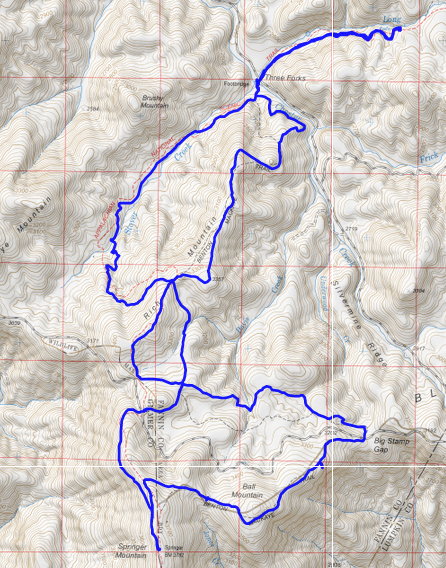
Long Creek Falls, Three Forks, Springer Mtn Double Figure-8 | |||||||
| The Basics: | |||||||
| Event Type: | Hike | ||||||
| Event Location: |
CNF near Springer Mountain


| ||||||
| Date(s) & Time: | Sun, Sep 20 2015 8:00 am >> Sun, Sep 20 2015 5:30 pm (Carpool Departure: 8:00 am *log in for location*) | ||||||
| Registration Opens: | Fri, Sep 18 2015 10:10 pm | ||||||
| Registration Cut Off: | Sat, Sep 19 2015 7:07 pm | ||||||
| Event Duration: | 9 Hours 30 Minutes | ||||||
| Difficulty Rating: | D5: Difficult | ||||||
| Distance: | 12.5 Miles | ||||||
| Pace: | Moderate | ||||||
| Trip Leader(s): | Mark Email Trip Leader(s) Email Trip Leader(s)
You must be logged in to get the Trip Leader contact information. | ||||||
| Member Cost: | None | ||||||
| Participant Info: | |||||||
| Who's Invited: | Members Only, 21 And Older Only | ||||||
| Maximum Group Size: | 12 | ||||||
| Minimum Group Size: | 2 | ||||||
| Number Registered So Far: | 6 / 0 (To see who's signed up, log in to the Member Area) | ||||||
| Are Dogs Permitted: | Yes | ||||||
| Itinerary: | |||||||
We will be hiking a Double Figure-8 loop on two of Georgia's most famous trails - the Appalachian Trail (AT) and the Benton MacKaye Trail (BMT). We will hike along Stover Creek, get to see Three Forks, Long Creek Falls, a nice overlook on the BMT, and Springer Mountain - the Southern Terminus of the AT. From the parking area we will begin hiking on the AT along Stover Creek, making a short stop at Three Forks, before arriving at the beautiful 50-ft cascading Long Creek Falls. This section of the hike is about 4 miles and mostly downhill, so it will be a nice warm up. We will take a nice break at Long Creek Falls to have some lunch, or snack, while enjoying the serenity of the falls. After leaving LCFs we will go back to Three Forks and then branch off on the BMT the rest of the way to Springer Mountain. Along the way, we will make a stop at a "off the beaten path" SE facing overlook with very nice views. We will also take a break at Springer Mountain, before taking the AT the short distance back to the parking area. This hike will be 12.5 miles in length and will total about 2,500 feet of ascent. Registrants should have, at minimum, solid D4 hiking experience. The weather forecast for Sunday is looking great! During the hike, we should have mostly sunny skies with temperatures ranging from 69-75 degrees, and a nice 5 mph breeze... beautiful. | |||||||
| |||||||
| How to Get There: | |||||||
| Event Directions: | Will be provided at carpool. Note: the last 7 miles of travel to the trailhead is on forest service roads. | ||||||
| Carpool to Event Distance (round trip): | 112Mile(s) | ||||||
| Carpool Departure Time: | 8:00 am | ||||||
| Carpool Location: | Log in for location | ||||||
| Carpool Directions: | Log in for directions | ||||||
| Carpool Cost: | Estimated cost per vehicle for this event is $44.80 using a reimbursement rate guideline of $0.400 per mile. The total amount should be divided by the number of people in the vehicle, including the driver. This is a guideline, not a rule, for drivers but the cost should not be higher unless there are extenuating circumstances. | ||||||
| Notes: | |||||||
|
* We encourage all members to follow our Etiquette Guidelines while participating in AOC events. | |||||||
Cancellation/Partial Attendance: Please review the AOC cancellation policy. | |||||||
 Calendar of Events
 Event Places