 Print-Friendly Version Print-Friendly Version
|
|
Smokey Mountains Foliage, Balds, Dome and More | |||||||
| The Basics: | |||||||
| Event Type: | Backpacking | ||||||
| Event Location: |
Great Smoky National Park


| ||||||
| Date(s) & Time: | Fri, Oct 16 2015 7:00 am >> Sun, Oct 18 2015 6:00 pm (Carpool Departure: 7:00 am *log in for location*) | ||||||
| Registration Opens: | Wed, Sep 30 2015 6:00 am | ||||||
| Registration Cut Off: | Wed, Oct 14 2015 11:59 pm | ||||||
| Event Duration: | 2 Days 11 Hours | ||||||
| Difficulty Rating: | D6: Advanced (Exploratory) | ||||||
| Distance: | 30 Miles | ||||||
| Pace: | Fast | ||||||
| Trip Leader(s): | Bill Armin  Email Trip Leader(s) Email Trip Leader(s)
You must be logged in to get the Trip Leader contact information. | ||||||
| Member Cost: | None | ||||||
| Participant Info: | |||||||
| Who's Invited: | Members Only, 21 And Older Only | ||||||
| Maximum Group Size: | 8 | ||||||
| Minimum Group Size: | 4 | ||||||
| Number Registered So Far: | 8 / 0 (To see who's signed up, log in to the Member Area) | ||||||
| Are Dogs Permitted: | No | ||||||
|
Note: This is an "EXPLORATORY" trip. This means that there are parts of this trip, or perhaps the whole trip, that is new to your Trip Leader(s). However, they are confident that this will not be an issue. This note is here so that you can make an informed decision. When a Trip Leader isn't personally familiar with a trip, there is an increased chance of things not going as planned and you need to be prepared. The Trip Leader may have additional details in the itinerary. | |||||||
| Itinerary: | |||||||
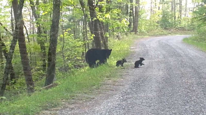
Join me for a 3 day 2 night experience in the Smokey Mountains. We'll have a bit of everything, stream crossings, water fall, capturing Silers and Andrews Bald, and a fantastic view from Clingman's Dome. If the forecast is right we should be in prime foliage season. Beginning Friday we'll drive to the Lakeview Drive Trail Head (Road to No Where). From the trail head we will hike 5 miles to camp site #71. We'll set up camp, gather fire wood and prepare for dinner. If we are settled early we can do a little exploring on near by trails. In the evening we'll enjoy hanging around the camp fire. Saturday is our big day hike. Plan on 20+ miles, over 5000 ft of elevation, possibly getting wet, and great views with fantastic colors. After breakfast we'll begin our journey north, gaining elevation on Forney Creek Trail for 1.2 miles. From there we take the Jonas Creek Trail north/west. Jonas Creek gives us 2200 ft of elevation gain, a magestic waterfall, stream crossings and a very wet trail all packed in 4.1 miles. We'll continue our hike North on Welch Ridge trail for about a mile to the top of Silers Bald. We'll spend a little time checking out the views from the Bald. from Silers we continue North for about a mile to the AT. We head east on the AT for about 4 miles to Clingmans Dome. We'll hang out for a bit at Clingmans, have some lunch, look around and take in the foliage views. After lunch we'll head South on the Foley Ridge Trail for about 1 mile to Andrews Bald. We'll descend the bald and continue on Foley Ridge Trail for another 3.5 miles till we intersect Springhouse Branch Trail. We continue west on Springhouse Branch for 4.2 miles back to camp site 71. At Camp we can rest our tired feet. Maybe clean up in a nearby stream, then prepare for our evening dinner and fire. Sunday morning slow go and out. We pack up camp sometime after breakfast and hike 5 miles back to the trail Head and our cars. I have reservations for 2 nights at camp site #71. The total cost is $64. With 8 backpackers that is $8 each. If we have less than 8, we'll divide the $64 among us equally. This is a long and physically demanding trip. For the safety of the group, the Trip Leaders reserve the right to remove anyone from the list they feel can not complete the journey. For the safety of the group participants should have the appropriate experience and ability to keep up with the group. | |||||||
| |||||||
| How to Get There: | |||||||
| Event Directions: | Get on I-85 N
Take I-985 N/Lanier Pkwy, US-23 N, US-441 N and US-74 W/Great Smoky Mountains Expy to Slope St in Bryson City
Follow Slope St, Bryson Walk and Lemons Branch Rd toLakeview Dr
| ||||||
| Carpool to Event Distance (round trip): | 300Mile(s) | ||||||
| Carpool Departure Time: | 7:00 am | ||||||
| Carpool Location: | Log in for location | ||||||
| Carpool Directions: | Log in for directions | ||||||
| Carpool Cost: | Estimated cost per vehicle for this event is $120.00 using a reimbursement rate guideline of $0.400 per mile. The total amount should be divided by the number of people in the vehicle, including the driver. This is a guideline, not a rule, for drivers but the cost should not be higher unless there are extenuating circumstances. | ||||||
| Notes: | |||||||
|
* We encourage all members to follow our Etiquette Guidelines while participating in AOC events. | |||||||
Cancellation/Partial Attendance: Please review the AOC cancellation policy. | |||||||
 Calendar of Events
 Event Places