 Print-Friendly Version Print-Friendly Version
|
|
Benton MacKaye Trail- Little Skeenah Creek to Wilscott Gap | |||||||
| The Basics: | |||||||
| Event Type: | Hike | ||||||
| Event Location: | 15 Miles North of Suches, GA | ||||||
| Date(s) & Time: | Sat, Oct 17 2015 7:00 am >> Sat, Oct 17 2015 3:30 pm (Carpool Departure: 7:00 am *log in for location*) | ||||||
| Registration Opens: | Tue, Oct 13 2015 7:00 am | ||||||
| Registration Cut Off: | Sat, Oct 17 2015 6:30 am | ||||||
| Event Duration: | 8 Hours 30 Minutes | ||||||
| Difficulty Rating: | D4: Moderate to Difficult (Exploratory) | ||||||
| Distance: | 11 Miles | ||||||
| Pace: | Moderate | ||||||
| Trip Leader(s): | Gary Hubert Email Trip Leader(s) Email Trip Leader(s)
You must be logged in to get the Trip Leader contact information. | ||||||
| Member Cost: | None | ||||||
| Participant Info: | |||||||
| Who's Invited: | Members Only, 21 And Older Only | ||||||
| Maximum Group Size: | 16 | ||||||
| Minimum Group Size: | 4 | ||||||
| Number Registered So Far: | 3 / 0 (To see who's signed up, log in to the Member Area) | ||||||
| Are Dogs Permitted: | Yes | ||||||
|
Note: This is an "EXPLORATORY" trip. This means that there are parts of this trip, or perhaps the whole trip, that is new to your Trip Leader(s). However, they are confident that this will not be an issue. This note is here so that you can make an informed decision. When a Trip Leader isn't personally familiar with a trip, there is an increased chance of things not going as planned and you need to be prepared. The Trip Leader may have additional details in the itinerary. | |||||||
| Itinerary: | |||||||
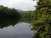
This 11 mile section of the Benton MacKaye trail crosses 3 mountains with elevations over 3,000 feet including Wallalah Mountain, Licklog Mountain, and Rhodes Mountain. There are several sections with long ascents and descents. Views are found at the top of Wallalah and Rhodes Mountain. This trip will require a short shuttle of approximately 5 miles on paved GA HWY 60 to allow us to do a section hike. We will have lunch at the top of one of the mountains along the way. *This trip is labeled as exploratory because it has been 7 years since I have hiked the trail.* | |||||||
| |||||||
| How to Get There: | |||||||
| Event Directions: | North on GA 400 from the park and ride. When GA 400 ends at the Chevron station make a left onto US-19/GA60 until you reach Dahlonega. From Dahlonega, take GA 60 north for approximately 20 miles until you reach the intersection of HWY 180 in Suches. Continue North on GA 60 for 14.8 more miles to the Benton MacKaye Trailhead. The parking lot is on the side of the road. | ||||||
| Carpool to Event Distance (round trip): | 150Mile(s) | ||||||
| Carpool Departure Time: | 7:00 am | ||||||
| Carpool Location: | Log in for location | ||||||
| Carpool Directions: | Log in for directions | ||||||
| Carpool Cost: | Estimated cost per vehicle for this event is $60.00 using a reimbursement rate guideline of $0.400 per mile. The total amount should be divided by the number of people in the vehicle, including the driver. This is a guideline, not a rule, for drivers but the cost should not be higher unless there are extenuating circumstances. | ||||||
| Notes: | |||||||
|
* We encourage all members to follow our Etiquette Guidelines while participating in AOC events. | |||||||
Cancellation/Partial Attendance: Please review the AOC cancellation policy. | |||||||
 Calendar of Events
 Event Places