 Print-Friendly Version Print-Friendly Version
|
|
Cohutta Waterfalls Loop | |||||||
| The Basics: | |||||||
| Event Type: | Hike | ||||||
| Event Location: |
Cohutta Wilderness


| ||||||
| Date(s) & Time: | Sun, Nov 15 2015 6:30 am >> Sun, Nov 15 2015 10:00 pm (Carpool Departure: 6:30 am *log in for location*) | ||||||
| Registration Opens: | Tue, Nov 10 2015 8:30 pm | ||||||
| Registration Cut Off: | Sat, Nov 14 2015 10:00 pm | ||||||
| Event Duration: | 15 Hours 30 Minutes | ||||||
| Difficulty Rating: | D6: Advanced (Exploratory) | ||||||
| Distance: | 20 Miles | ||||||
| Pace: | Moderate | ||||||
| Trip Leader(s): | Eric P Email Trip Leader(s) Email Trip Leader(s)
You must be logged in to get the Trip Leader contact information. | ||||||
| Member Cost: | None | ||||||
| Participant Info: | |||||||
| Who's Invited: | Members Only, 21 And Older Only | ||||||
| Maximum Group Size: | 4 | ||||||
| Minimum Group Size: | 2 | ||||||
| Number Registered So Far: | 4 / 0 (To see who's signed up, log in to the Member Area) | ||||||
| Are Dogs Permitted: | No | ||||||
|
Note: This is an "EXPLORATORY" trip. This means that there are parts of this trip, or perhaps the whole trip, that is new to your Trip Leader(s). However, they are confident that this will not be an issue. This note is here so that you can make an informed decision. When a Trip Leader isn't personally familiar with a trip, there is an increased chance of things not going as planned and you need to be prepared. The Trip Leader may have additional details in the itinerary. | |||||||
| Itinerary: | |||||||
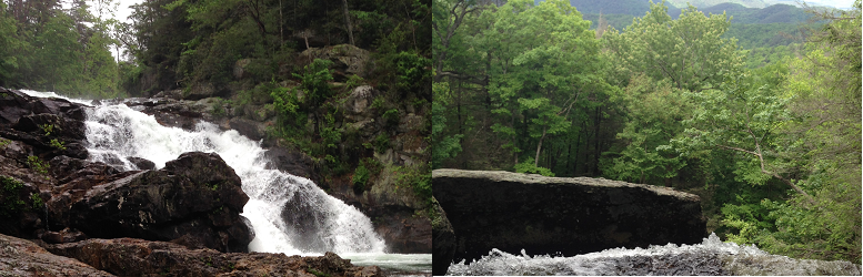
I have been getting a little stir crazy as a new dad and need to get out into the wilderness and figured I would offer this up for a small group. I will not be moving as fast as usual but it still will not be a slow pace as we only have so much day light. This loop hits the two main waterfalls(Jacks River and Panther Creek Falls) without going through quite as many river crossings as some other Cohutta options. With that being said it does go through one of the toughest Jacks River crossings.
Many people like hiking poles for the river crossings but they are not required and I do not personally bring them. Additionally know that we will not be stopping at every crossing to change shoes and you should be able to walk in wet shoes. | |||||||
| |||||||
| How to Get There: | |||||||
| Event Directions: | From the GA 52-US 411 intersection in Chatsworth, travel US 411 North approximately 13.4 miles, past Eton toward Tennga, to the community of Cisco. In Cisco, turn right onto the paved road immediately before the Cisco Baptist Church, also on the right. Once part of GA 2, this road is now known as Old GA 2. This road is also FS 16. Continue on FS 16 (the pavement ends; stay to the right at the fork; pass Hopewell Church; cross the Conasauga River) for approximately 7.9 miles, then turn right onto FS 51. Proceed about 4.8 miles} making two fords. The fords may require a utility vehicle in wet weather. You will find the Rice Camp trailhead, bulletin board, and parking area on the left. As you approach, Rice Camp Trail is to the left and East Cowpen Trail is straight ahead into the wilderness. | ||||||
| Carpool to Event Distance (round trip): | 180Mile(s) | ||||||
| Carpool Departure Time: | 6:30 am | ||||||
| Carpool Location: | Log in for location | ||||||
| Carpool Directions: | Log in for directions | ||||||
| Carpool Cost: | Estimated cost per vehicle for this event is $72.00 using a reimbursement rate guideline of $0.400 per mile. The total amount should be divided by the number of people in the vehicle, including the driver. This is a guideline, not a rule, for drivers but the cost should not be higher unless there are extenuating circumstances. | ||||||
| Notes: | |||||||
|
I plan on driving and having the small group of 4 all in one car. * We encourage all members to follow our Etiquette Guidelines while participating in AOC events. | |||||||
Cancellation/Partial Attendance: Please review the AOC cancellation policy. | |||||||
 Calendar of Events
 Event Places