 Print-Friendly Version Print-Friendly Version
|
|
Thunderhead Loop - GSMNP | |||||||
| The Basics: | |||||||
| Event Type: | Backpacking | ||||||
| Event Location: |
Great Smoky Mountains National Park


| ||||||
| Date(s) & Time: | Fri, Mar 11 2016 6:15 am >> Sun, Mar 13 2016 6:30 pm (Carpool Departure: 6:30 am *log in for location*) | ||||||
| Registration Opens: | Tue, Feb 10 2015 8:00 pm | ||||||
| Registration Cut Off: | Wed, Mar 9 2016 6:00 pm | ||||||
| Event Duration: | 2 Days 11 Hours 15 Minutes | ||||||
| Difficulty Rating: | D6: Advanced (Exploratory) | ||||||
| Distance: | 28 Miles | ||||||
| Pace: | Moderate | ||||||
| Trip Leader(s): | Mike Pawloski Jane  Email Trip Leader(s) Email Trip Leader(s)
You must be logged in to get the Trip Leader contact information. | ||||||
| Member Cost: | None | ||||||
| Participant Info: | |||||||
| Who's Invited: | Members Only, 21 And Older Only | ||||||
| Maximum Group Size: | 8 | ||||||
| Minimum Group Size: | 2 | ||||||
| Number Registered So Far: | 8 / 0 (To see who's signed up, log in to the Member Area) | ||||||
| Are Dogs Permitted: | No | ||||||
|
Note: This is an "EXPLORATORY" trip. This means that there are parts of this trip, or perhaps the whole trip, that is new to your Trip Leader(s). However, they are confident that this will not be an issue. This note is here so that you can make an informed decision. When a Trip Leader isn't personally familiar with a trip, there is an increased chance of things not going as planned and you need to be prepared. The Trip Leader may have additional details in the itinerary. | |||||||
| Itinerary: | |||||||
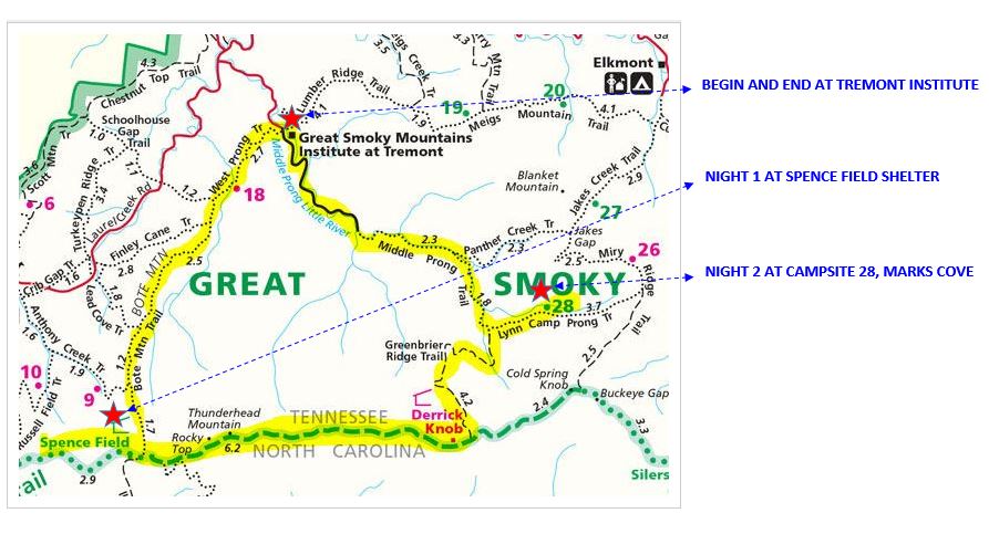
Tiptoe across airy ridges, spot resident black bear, and take in the best of the Smokies on this three-day, two night 28 mile loop.
We begin at the Tremont Institute on Middle Prong Road near Townsend, TN and ascend the West Prong Trail through hardwood forest peppered with mountain laurel thickets (in June their branches are hung with white and red "peppermint" blossoms)
We continue on the Bote Mountain Trail, climbing more than 3,000 feet over 9 miles. Heading past Cold Water Knob, enjoy the northwest vistas into the rolling meadows of Cades Cove.
Near the top of the climb, the trail enters tunnels of rhododendron. As we emerge onto the crest of the ridge, we'll turn right onto the Appalachian Trail, then take an immediate right toward the stone Spence Field Shelter. Complete with a fireplace and spring, the shelter is equipped with cables to hang our food out of reach of black bears—just don’t forget about smaller pests. With an early start the next day we backtrack on the AT. We continue to some of the Smokies best known peaks: 5,441-foot Rocky Top and 5,527-foot Thunderhead. We'll take in the long-distance views from the ridge, then dip into a saddle before ascending through wind-stunted trees to Thunderhead. We climb the summit cairn for views over neck-high vegetation, then reenter the beeches. Water is available at the Derrick Knob Shelter if we need to hydrate or want a place to take a break.
We turn left on to the well-graded Greenbrier Ridge Trail. We'll continue to the Lynn Camp Prong Trail and turn right (looking for tracks of reintroduced elk) and hike ~1.5 miles to secluded Campsite # 28, Marks Cove. This site accommodates both humans and horses overnight. It has a stream to refill water, hitching posts for horses, a fire ring, several crude log benches, and hoists to keep our packs out of bear range.
Next morning, we backtrack to the last intersection and turn right onto Middle Prong Trail, showcasing the emerald-green pools below Lynn Camp Falls. We gradually descend along the river to Tremont Road and road-walk the final 3.1 miles to close the loop.
Day 1 - approx. 9 miles
Day 2 - approx. 12 miles
Day 3 - approx. 7 miles
This is a demanding backpacking trip. For safety reasons, Trip Leaders will be screening anyone who does not appear to have adequate backcountry experience. This may result in removal from the attendee list.
| |||||||
| |||||||
| How to Get There: | |||||||
| Event Directions: | From Atlanta take I-75 N to Lenoir City - exit #81. Follow 321 North ONCE IN THE PARK: When coming in from Townsend, follow the road to the Y-intersection with signs to Gatlinburg or Cades Cove. Turn right towards Cades Cove, then immediately you will see a sign indicating the road to the Great Smoky Mountains Institute. Turn left across the bridge and follow the Tremont road 2 miles (you will cross two, two-lane bridges) to the Institute turning left across the 1-lane bridge. Office is on the left. We will check in. | ||||||
| Carpool to Event Distance (round trip): | 420Mile(s) | ||||||
| Carpool Departure Time: | 6:30 am | ||||||
| Carpool Location: | Log in for location | ||||||
| Carpool Directions: | Log in for directions | ||||||
| Carpool Cost: | Estimated cost per vehicle for this event is $168.00 using a reimbursement rate guideline of $0.400 per mile. The total amount should be divided by the number of people in the vehicle, including the driver. This is a guideline, not a rule, for drivers but the cost should not be higher unless there are extenuating circumstances. | ||||||
| Notes: | |||||||
|
Survey Elevation: Total Gain: 7121 ft Friday, March 11 Sunrise: 6:59am Sunset: 6:36pm Saturday, March 12 Sunrise: 6:47am Sunset: 6:37pm Sunday, March 13 DST begins Sunrise: 7:46am Sunset: 7:38pm www.sunrisesunset.com/USA/NationalParks/ Please note that Townsend, TN has an elevation of 1,066 ft. We will be at higher elevations and therefore temperatures will be colder than those listed below. For example, Spence Field Shelter has an elevation of 4,915 ft. You can use this formula to estimate what the temperature change will be with elevation: http://treelinebackpacker.com/2013/05/06/calculate-temperature-change-with-elevation/ Equation ( 3.5 x Change in elevation) = temp loss due to elevation change or (3.5ΔH=Tf) You will lose an average 3.5 degrees Fahrenheit for every 1000 feet of elevation you gain. So, for Spence Field Shelter: (4,915 - 1,066)/1000 = 3.849 {This is the Change in Elevation multiplier} 3.5 x 3.9 = 13.7 {This is the temp loss due to elevation} If we use the Daily Normals for our Friday, March 11 stay at Spence Field Shelter: 57.9 - 13.7 = 44.2 {This is the average high temp at Spence Field Shelter} 32.9 - 13.7 = 19.2 {This is the average low temp at Spence Field Shelter} We can expect temps to be even colder at night. Other factors will impact the actual value of these calculations. Cloud cover will trap in more heat, whereas a clear sky will drop the temperature slightly faster. Cold fronts and air streams may also have an effect, as well as local evaporation cooling. These factors are too numerous to account for, so the equation is designed as a worst case scenario calculation (after rounding). * We encourage all members to follow our Etiquette Guidelines while participating in AOC events. | |||||||
Cancellation/Partial Attendance: Please review the AOC cancellation policy. | |||||||
 Calendar of Events
 Event Places