 Print-Friendly Version Print-Friendly Version
|
|
High Falls, Big Scaly and Standing Indian - Third Attempt | |||||||
| The Basics: | |||||||
| Event Type: | Hike | ||||||
| Event Location: |
Tate City, Georgia


| ||||||
| Date(s) & Time: | Sat, Feb 6 2016 7:30 am >> Sat, Feb 6 2016 8:30 pm (Carpool Departure: 7:30 am *log in for location*) | ||||||
| Registration Opens: | Mon, Feb 1 2016 7:00 pm | ||||||
| Registration Cut Off: | Fri, Feb 5 2016 1:00 pm | ||||||
| Event Duration: | 13 Hours | ||||||
| Difficulty Rating: | D5: Difficult (Exploratory) | ||||||
| Distance: | 12.5 Miles | ||||||
| Pace: | Moderate | ||||||
| Trip Leader(s): | Jared S Email Trip Leader(s) Email Trip Leader(s)
You must be logged in to get the Trip Leader contact information. | ||||||
| Member Cost: | None | ||||||
| Participant Info: | |||||||
| Who's Invited: | Members Only, 21 And Older Only | ||||||
| Maximum Group Size: | 8 | ||||||
| Minimum Group Size: | 2 | ||||||
| Number Registered So Far: | 7 / 0 (To see who's signed up, log in to the Member Area) | ||||||
| Are Dogs Permitted: | Yes | ||||||
|
Note: This is an "EXPLORATORY" trip. This means that there are parts of this trip, or perhaps the whole trip, that is new to your Trip Leader(s). However, they are confident that this will not be an issue. This note is here so that you can make an informed decision. When a Trip Leader isn't personally familiar with a trip, there is an increased chance of things not going as planned and you need to be prepared. The Trip Leader may have additional details in the itinerary. | |||||||
| Itinerary: | |||||||
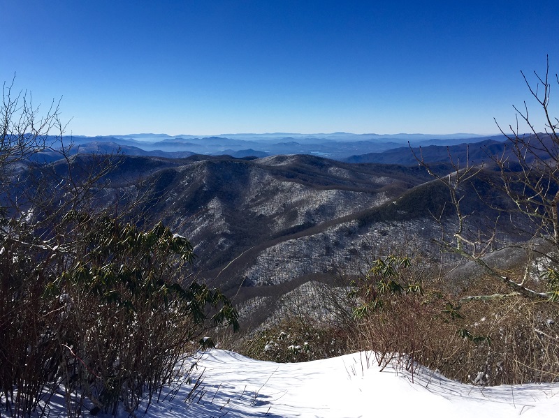
While we did hike in the area in our last attempt, we didn't get to the falls, the steep section or Big Scaly. So let's try this again. This hike will visit a couple of fantastic views along with a great waterfall. We probably won't see many people on this hike, just the way us nature freaks like it. I have done most of this hike but I want to try a seldum used connector trail that connects the Beech Creek Trail to the AT near High Falls. According to Dorothea, this is the steepest trail she's ever hiked. This hike will start at the Beech Creek trail head. From there we will start by hiking up the Beech Creek Trail and cross Beech creek about 1 mile into the hike. This creek can sometimes be rock hopped but be ready to take your shoes off. We will continue on old logging roads up into the cove where we will visit High Falls. If it's cold enough, High Falls may be a bit icy. From there, instead of following the trail to Case Knife Gap and to Scaly or Standing, we will attempt to find the connector trail that Dorothea has told me about. Backtracking from High Falls just a bit, we will cross Beech Creek again and head up a steep hill. Dorothea: Climbing up the connector trail, after a rough beginning you will soon be "faced with a smooth rock wall that disappears into the sky. Actually it took me 30 minutes to climb up it. The rock wall does not have much to hold on, a shrub here and a patch of weeds there. To make it really fun a huge tree has fallen over the “trail” and you have to climb over at least 3 big branches. When you get to the top and reach Beech Gap, it is the sweetest spot on earth. If you look around you can find the spring for the creek. It flows out from under the roots of a tree. Magical." This connector trail, according to the map, will be on the order of 2400 feet per mile for a quarter mile, a 45% average grade! I've done 45% grades off-trail and while I find them easier up hill as opposed to down hill, wet leaves over dirt can make things very tricky. Not to mention, the rock face. There is a real possibility that we have to turn around and take the normal, but still steep path the AOC takes to Standing Indian. From Beech Gap it is a gentle (relatively) climb up to the vista on Standing Indian. Standing Indian stands at 5,499 feet; the highest mountain in the Southern Nantahala Wilderness. You can read the interesting story of how Standing Indian received its name on Wikipedia. From Standing Indian we will back track to the primative trail that connects the AT down to Case Knife Gap. This connector trail is quite steep and off-trail so be ready for the buttslide maneuver. Assuming we have enough daylight remaining, from Case Knife Gap we will begin another climb up Big Scaly. The trail up the north ridge is a heard path at best and not properly maintained. Once on top of Big Scaly Mountain, we will get to a fantastic overlook as pictured above. After a short rest we will back track down the ridge and from Case Knife Gap we will take old logging roads back down to the road we started on. Once we reach the road we still have a bit of road walking to do to get back to the cars. This hike will be 12-13 miles long and have about 3700-4000 feet of elevation gain. Faster hikers can go ahead if they have done this hike before and are familiar with the area but we will stop at all the major trail intersections to regroup. There are a couple of turns people often miss so anyone that is not sure where the turns are will need to stay with the group. This hike will probably take 7 hours but could take as long as 9 depending on the group. The drive is about 2 hours each way not counting the usual break on the way up or dinner on the way back. After the hike we will stop in Clayton for dinner if enough people are interested (Ujoint is my preference). Make sure you make your plans known at the carpool if you need to return early. NOTE: This hike will be cancelled if the chance of thunderstorms is 50% or greater or a steady all day rain is forecast. I also my cancel if it will be <40s, windy and cloudy. As always, bring a change of clothes and shoes along with bags to put dirty stuff in. Keep your carpool driver's car clean!
| |||||||
| |||||||
| How to Get There: | |||||||
| Event Directions: | Directions to trailhead will be given at carpool (or print your own: https://goo.gl/maps/U5hM9kKa Aq22). GPS: Tate City, Georgia 34.9953461, -83.5561566 | ||||||
| Carpool to Event Distance (round trip): | 210Mile(s) | ||||||
| Carpool Departure Time: | 7:30 am | ||||||
| Carpool Location: | Log in for location | ||||||
| Carpool Directions: | Log in for directions | ||||||
| Carpool Cost: | Estimated cost per vehicle for this event is $84.00 using a reimbursement rate guideline of $0.400 per mile. The total amount should be divided by the number of people in the vehicle, including the driver. This is a guideline, not a rule, for drivers but the cost should not be higher unless there are extenuating circumstances. | ||||||
| Notes: | |||||||
|
* We encourage all members to follow our Etiquette Guidelines while participating in AOC events. | |||||||
Cancellation/Partial Attendance: Please review the AOC cancellation policy. | |||||||
 Calendar of Events
 Event Places

