 Print-Friendly Version Print-Friendly Version
|
|
Mount LeConte - Annual Great Smoky Mountains Scenic Adventure: All Day Affair | |||||||
| The Basics: | |||||||
| Event Type: | Hike | ||||||
| Event Location: |
Great Smoky Mountains National Park, NC & TN


| ||||||
| Date(s) & Time: | Sat, May 28 2016 6:00 am >> Sat, May 28 2016 8:00 pm (Carpool Departure: 6:00 am *log in for location*) | ||||||
| Registration Opens: | Thu, Apr 14 2016 8:00 pm | ||||||
| Registration Cut Off: | Fri, May 27 2016 11:59 pm | ||||||
| Event Duration: | 14 Hours | ||||||
| Difficulty Rating: | D5: Difficult | ||||||
| Distance: | 11 Miles | ||||||
| Pace: | Moderate | ||||||
| Trip Leader(s): | Tom Jarosz Stacey Johnson  Email Trip Leader(s) Email Trip Leader(s)
You must be logged in to get the Trip Leader contact information. | ||||||
| Member Cost: | None | ||||||
| Participant Info: | |||||||
| Who's Invited: | Members Only, 21 And Older Only | ||||||
| Maximum Group Size: | 12 | ||||||
| Minimum Group Size: | 4 | ||||||
| Number Registered So Far: | 14 / 0 (To see who's signed up, log in to the Member Area) | ||||||
| Are Dogs Permitted: | No | ||||||
| Itinerary: | |||||||
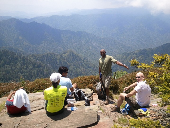
Note: EVERYONE MUST MEET AT CARPOOL. The group will be departing the Indian Trail Park and Ride at 6:00 AM sharp and carpooling. There will be no other carpool locations, other meet up locations, or meeting at the event. We will all be driving to the event as one group, but for those staying after the hike make sure you are in like-minded carpools. Come join us for an 'All Day' adventure trip to the Smoky Mountains & hike up to LeConte Mountain! If ever there was a classic hike in Great Smoky Mountains National Park, the Alum Cave Trail to Mount LeConte would certainly qualify. Sure, there are trails in the Smokies that are far longer, that gain more elevation, or have steeper climbs, but the Alum Cave Trail is unmatched in its combination of interesting geological features, history, high adventure and stunning views. To reach the 6593-foot summit of Mount LeConte, you'll climb 2763 feet and hike 5.5 miles from the Alum Cave trailhead and return down the same route - very scenic views.
Trail Description: The first section of trail, up to Arch Rock, is a fairly gentle climb. You'll follow the Alum Cave Creek for the first mile, before switching to the smaller Styx Branch just below Arch Rock. This section of trail is choked with rhododendron, offering beautiful blooms in early summer. At just over 1.3 miles from the trailhead you'll reach Arch Rock, the first prominent landmark along the trail. The arch was formed by freezing and thawing which eroded away the softer rock from underneath the harder rock. The trail actually goes under the arch and requires a climb of several steps etched into the rock to exit at the top. At roughly 2 miles into the hike you'll reach Inspiration Point with its commanding views of Little Duck Hawk Ridge to the west of you and Myrtle Point on Mount LeConte towards the northeast. The Eye of the Needle, a hole in the rock near the top of Little Duck Hawk Ridge, can also be seen from Inspiration Point. At 2.2 miles you'll reach Alum Cave, which, really isn't a cave, but is actually a concaved bluff, about 80 feet high and roughly 500 feet in length. During the warmer months of the year, water drips off the ledges above you. In the winter, these water droplets form into large icicles. During the Civil War, the Confederate Army mined saltpeter out of the cave in order to manufacture gunpowder. The views from Alum Cave are outstanding. Just past Alum Cave is Gracie's Pulpit. This landmark is named after Gracie McNichol, who, believe or not, hiked to Mount LeConte on her 92nd birthday. At roughly 2.6 miles from the trailhead, the pulpit marks the halfway point to Mt. LeConte. Over the next two miles you'll pass over several rock ledges, many with cable hand rails. A few of these ledges pass small waterfalls, requiring some negotiation to get around them while grasping on the cables. On a hot day, the cool water splashing on you is quite welcome. The last of these ledges passes right beneath Cliff Top. Once beyond this point the trail flattens out and you enter a spruce-fir forest. Before long, the LeConte Lodge cabins come into view. Before reaching the lodge, at just over 5 miles from the trailhead, the Alum Cave Trail dead-ends into the Rainbow Falls Trail. Before reaching the summit, the Trillium Gap Trail will branch off to your left at 5.2 miles. The summit, better known as High Top, will be at 5.5 miles. You'll know you've reached the highest point on Mt. LeConte when you've reached the cairn, or pile of rocks, just off the main trail on the right. At 6593 feet, Mount LeConte is the third highest peak in the Smokies. However, from its immediate base to its highest peak, Mt. LeConte is the tallest mountain in the Eastern United States, rising 5301 feet from its base near Gatlinburg. You won't have any views up at High Top; There are two places on the mountain where you can find outstanding panoramic views.. We will stop and have lunch to enjoy the views at the summit of LeConte.
Registration Requirements: Given the elevation gains and physical intensity achieved during this hike, along with the challenge of being an all day event, only hikers with significant D5 experience or equivalent should register. The Trip Leader(s) also reserve the right to consider any registrant’s hiking, event, and social history within the AOC and to make the final determination as to whether the registrant is an appropriate candidate for this event. | |||||||
| |||||||
| How to Get There: | |||||||
| Event Directions: | From Spaghetti Junction (I-85/I-285 Interchange in NE Atlanta): | ||||||
| Carpool to Event Distance (round trip): | 331Mile(s) | ||||||
| Carpool Departure Time: | 6:00 am | ||||||
| Carpool Location: | Log in for location | ||||||
| Carpool Directions: | Log in for directions | ||||||
| Carpool Cost: | Estimated cost per vehicle for this event is $132.40 using a reimbursement rate guideline of $0.400 per mile. The total amount should be divided by the number of people in the vehicle, including the driver. This is a guideline, not a rule, for drivers but the cost should not be higher unless there are extenuating circumstances. | ||||||
| Notes: | |||||||
|
* We encourage all members to follow our Etiquette Guidelines while participating in AOC events. | |||||||
| Cost Includes: | Free event! | ||||||
Cancellation/Partial Attendance: Please review the AOC cancellation policy. | |||||||
 Calendar of Events
 Event Places