 Print-Friendly Version Print-Friendly Version
|
|
Map & Compass Practice Hike at Lake Allatoona + Optional Cookout/Picnic | |||||||
| The Basics: | |||||||
| Event Type: | Hike | ||||||
| Event Location: | Red Top Mountain State Park Visitor Center | ||||||
| Date(s) & Time: | Sat, Nov 1 2008 9:30 am >> N/A (Carpool Departure: 8:45 am *log in for location*) | ||||||
| Registration Opens: | Thu, Oct 9 2008 10:30 pm | ||||||
| Registration Cut Off: | Tue, Oct 28 2008 10:30 pm | ||||||
| Event Duration: | 5 Hours | ||||||
| Difficulty Rating: | D2: Easy to Moderate | ||||||
| Trip Leader(s): | Paula Schubert Charlie Cottingham  Email Trip Leader(s) Email Trip Leader(s)
You must be logged in to get the Trip Leader contact information. | ||||||
| Member Cost: | None | ||||||
| Participant Info: | |||||||
| Who's Invited: | Members Only, 21 And Older Only | ||||||
| Maximum Group Size: | 25 | ||||||
| Minimum Group Size: | 5 | ||||||
| Number Registered So Far: | 22 / 0 (To see who's signed up, log in to the Member Area) | ||||||
| Are Dogs Permitted: | No | ||||||
| Itinerary: | |||||||
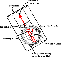
Thirty AOC members and guests turned out for our Sep 6 AOC "Map & Compass Hike on the Hooch," and everyone seemed to have a wonderful time. Many of you have asked for another opportunity to refresh and practice our basic map & compass skills in conjunction with another adventurous dayhike -- so here it is! You need not have taken part in the September "O meet" to register for this Nov 1 event and enjoy it. The GA Orienteering Club (our hosts for the Sep "O meet") have laid out a scenic 2-mile permanent "map & compass practice course" on the shore of Lake Allatoona in beautiful Redtop Mountain State Park just north of Atlanta. Below is our suggested timeline for this event which includes having fun finding the dozen or so permanent markers on this "O course." Charlie will provide a few "loaner" compasses and plenty of copies of the detailed topo map of the O course. Suggested Event Timeline: 8:45 AM: Meet for (optional) carpooling at Busbee Pkwy CCT park/ride lot around the corner from I-75 “Chastain Rd” Exit #271 (see below). We'll plan to depart by 9:00AM. If it's more convenient for you, meet us at 9:30 at the State Park Visitor Center (see below) about 16 miles north of the park/ride lot. 9:30 AM: Re-group at the Red Top Mtn State Park Visitor Center. (It's about 2.0 miles E of I-75 “Red Top Mtn Rd” Exit #285. Our planned "O-Hike HQ and Start Area" will be at the hill-top picnic tables beside the tennis court and parking lot that adjoin the Visitor Center.) Make sure all waivers are signed and self-serve parking fees are paid. If parking spaces are scarce, feel free to park in the flat grassy area beyond the tennis court. 9:45 AM: We'll host a brief informal “Map & Compass Refresher Tutorial" and "Intro to the Sport of Orienteering”. 10:15 AM: We'll divide into 4 or 5 small "lightly competitive" teams and one non-competitive group "wayfaring" team (which Charlie will plan to lead as a moderately paced hike, with more map & compass instruction along the way). Individuals who wish to navigate the "O" course on their own are also welcome to do so. 10:30 - 12:30: Teams will be given staggered start times (from the Visitor Center parking area) by a couple of volunteers with a stop watch, and their return times noted ~1 to 2 hours later. Various prizes will be awarded for “notable” performances! 12:45-2:00 PM: For all who would like to take part, Charlie will head up an optional “potluck” group cookout in a nearby picnic area by the lake. Our planned area for this will be the pretty peninsula that juts out into the lake beyond "Picnic Area #7" at the end of Red Top Beach Road (just a short distance back toward I-75 from the Visitor Center). If you wish to participate, bring something compact to throw on the grill, a small side item to share (e.g., salad, munchie, hors d'oeuvre, covered dish, dessert, etc.) and a non-alcoholic beverage of your choice in a small cooler. Charlie will provide a fired-up charcoal grill or two, paper plates, plastic ware, napkins, cups, a cooler of lemonade, a few condiments, etc. | |||||||
| |||||||
| How to Get There: | |||||||
| Event Directions: | This beautiful and popular State Park is on Lake Allatoona, about 30 miles NW of Atlanta via I-75. Please note: Each carpool group is responsible for paying the self-service parking fee by depositing $3 in a self-service envelope. Tear off the envelope's receipt tab and hang it from your vehicle's rear-view mirror. (GA State Parks annual parking passes are available at the Visitor Center for $30 in lieu of these $3-per-visit fees.) We'll gather for the event at 9:30AM at the picnic table area (by the tennis court) on top of the hill by the parking lot and Visitor Center. | ||||||
| Carpool to Event Distance (round trip): | 35Mile(s) | ||||||
| Carpool Departure Time: | 8:45 am | ||||||
| Carpool Location: | Log in for location | ||||||
| Carpool Directions: | Log in for directions | ||||||
| Carpool Cost: | Estimated cost per vehicle for this event is $14.00 using a reimbursement rate guideline of $0.400 per mile. The total amount should be divided by the number of people in the vehicle, including the driver. This is a guideline, not a rule, for drivers but the cost should not be higher unless there are extenuating circumstances. | ||||||
| Notes: | |||||||
|
* We encourage all members to follow our Etiquette Guidelines while participating in AOC events. | |||||||
Cancellation/Partial Attendance: Please review the AOC cancellation policy. | |||||||
 Calendar of Events
 Event Places