 Print-Friendly Version Print-Friendly Version
|
|
Siler Bald - Backpacking On The NC Applachian Trail | |||||||
| The Basics: | |||||||
| Event Type: | Backpacking | ||||||
| Event Location: |
Winding Stair Gap - 8 mi West of Franklin NC on US 64


| ||||||
| Date(s) & Time: | Sat, Feb 20 2016 8:30 am >> Sun, Feb 21 2016 4:00 pm (Carpool Departure: 8:30 am *log in for location*) | ||||||
| Registration Opens: | Fri, Feb 5 2016 8:00 pm | ||||||
| Registration Cut Off: | Fri, Feb 19 2016 12:00 pm | ||||||
| Event Duration: | 1 Days 7 Hours 30 Minutes | ||||||
| Difficulty Rating: | D4: Moderate to Difficult | ||||||
| Pace: | Moderate | ||||||
| Trip Leader(s): | Kristi Email Trip Leader(s) Email Trip Leader(s)
You must be logged in to get the Trip Leader contact information. | ||||||
| Member Cost: | None | ||||||
| Participant Info: | |||||||
| Who's Invited: | Members Only, 21 And Older Only | ||||||
| Maximum Group Size: | 10 | ||||||
| Minimum Group Size: | 6 | ||||||
| Number Registered So Far: | 8 / 0 (To see who's signed up, log in to the Member Area) | ||||||
| Are Dogs Permitted: | Yes | ||||||
| Itinerary: | |||||||
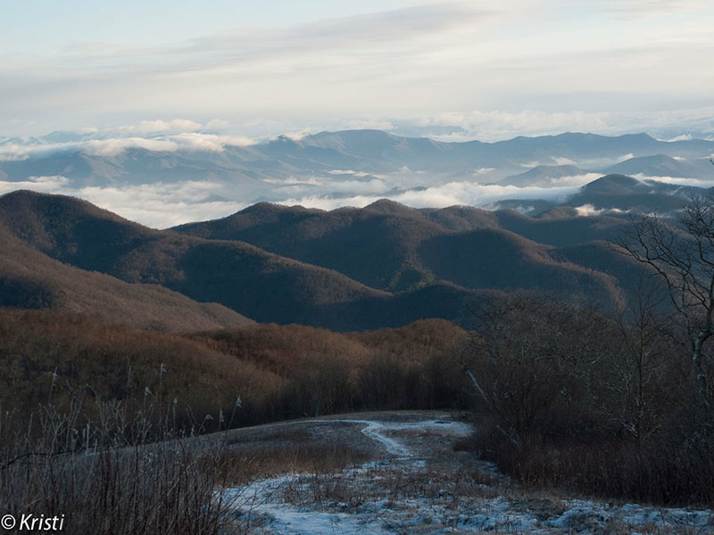
With a summit of 5,216 feet Siler Bald offers a sweeping 360 degree view of the surrounding valleys. And while there is almost 1500 feet in elevation gain, most of it is fairly gradual over four miles. The total distance hiked over two days will be around 8-10 miles, depending on how many trips you make to the summit, from the campsite. We'll leave the park-n-ride at 8:30am We should be on the trail around 10:30am, hiking a total of 4 miles to the campsite. At about mile 3, we will veer off of the A.T. to the marked side trail to collect water from a spring located near the shelter. Be prepared for some ice on the trail. Note, we are not camping at the shelter. After collecting water, we will continue up a steep trail (about 1/2 mile) to the base of Siler Bald at Snowbird Gap; we will camp in a grove of trees. You can either filter the water at the spring, or do it later at the campsite; I will filter at the spring. Once at camp, we can set up camp, eat lunch, gather wood for a fire, relax. We can make the 5-10 minute walk to the top of Siler as many times as we want, but we will definitely want to see the sun set from the top. On Sunday, we will plan to leave camp around 10:30am, hike back to the cars on the A.T. The morning sunrise from the top is particularly special. There is no water at the campsite, so I recommend that you start the hike with 1.5 or 2 liters. At the shelter on the way up, collect enough water for the remainder of Saturday and Sunday morning; I recently did this hike and had about 4 1/2 liters of water for drinking and cooking. Alternatively, you can hike all the way to the campsite and then make a return trip down to the water source. Up to two dogs allowed on this event... must be well tended to in the cold with appropriate dog blanket, etc. I love dogs and don't want to see it shivering. :-) Weather report - Snowbird Gap location: http://forecast.weather.gov/MapClick.php?lat=35.1393&lon=-83.5771#.VrnbVsCAOko Thanks goes to Tom J for many of the detailed descriptions of this trip event! Email me if you have any questions. Kristi@atlantaoutdoorclub.com | |||||||
| |||||||
| How to Get There: | |||||||
| Event Directions: | North on I-85. Take I-985 near Mall of Georgia. Continue on I-985. After 26 miles this intersate will become US 23. Continue on US 23 through Clayton GA and into North Carolina. At Franklin NC take exit to US 64 West. Continue eight miles until Winding Stairs Gap parking lot. | ||||||
| Carpool to Event Distance (round trip): | 235Mile(s) | ||||||
| Carpool Departure Time: | 8:30 am | ||||||
| Carpool Location: | Log in for location | ||||||
| Carpool Directions: | Log in for directions | ||||||
| Carpool Cost: | Estimated cost per vehicle for this event is $94.00 using a reimbursement rate guideline of $0.400 per mile. The total amount should be divided by the number of people in the vehicle, including the driver. This is a guideline, not a rule, for drivers but the cost should not be higher unless there are extenuating circumstances. | ||||||
| Notes: | |||||||
|
***Event will be postponed if a lot of rain is forecast, nighttime temps in single digits, or if roads are not safe due to snow or ice. * We encourage all members to follow our Etiquette Guidelines while participating in AOC events. | |||||||
Cancellation/Partial Attendance: Please review the AOC cancellation policy. *Note: Late cancellations, particularly within 36 hours of the event make it difficult for those on the wait list to attend. Please be courteous to your fellow AOC members and cancel with as much notice as possible. | |||||||
 Calendar of Events
 Event Places