 Print-Friendly Version Print-Friendly Version
|
|
Chestnut Mountain and Dick’s Knob | |||||||
| The Basics: | |||||||
| Event Type: | Hike | ||||||
| Event Location: |
Near Tate City, Ga


| ||||||
| Date(s) & Time: | Sat, Feb 27 2016 8:00 am >> Sat, Feb 27 2016 6:00 pm (Carpool Departure: 8:00 am *log in for location*) | ||||||
| Registration Opens: | Tue, Feb 23 2016 8:08 pm | ||||||
| Registration Cut Off: | Fri, Feb 26 2016 2:22 pm | ||||||
| Event Duration: | 10 Hours | ||||||
| Difficulty Rating: | D5: Difficult | ||||||
| Distance: | 9 Miles | ||||||
| Pace: | Moderate | ||||||
| Trip Leader(s): | Aaron Email Trip Leader(s) Email Trip Leader(s)
You must be logged in to get the Trip Leader contact information. | ||||||
| Member Cost: | None | ||||||
| Participant Info: | |||||||
| Who's Invited: | Members Only, 21 And Older Only | ||||||
| Maximum Group Size: | 10 | ||||||
| Minimum Group Size: | 2 | ||||||
| Number Registered So Far: | 10 / 0 (To see who's signed up, log in to the Member Area) | ||||||
| Are Dogs Permitted: | Yes | ||||||
| Itinerary: | |||||||
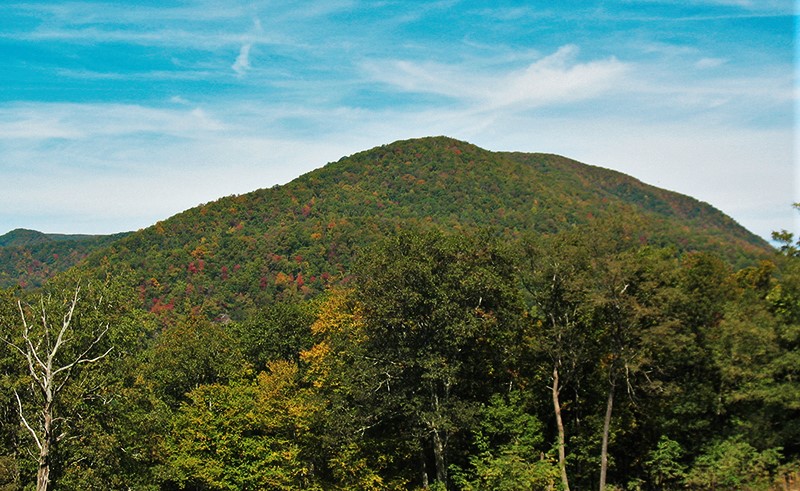
Standing 4,620' above sea level, Dick's Knob is Georgia's 3rd highest peak if using a 200ft prominence rule. Regardless of the prominence details, Dick's Knob is one of the highest peaks in the state, sits in the Southern Nantahala Wilderness Area, and is definitely worthy of visit.
The route to Dick's Knob will start from the Tate Branch Campground on the Tallulah River Rd (also called Tate City Rd). There are no trails that go to Dick's Knob, so this hike will involve an extensive amount of "off-trail" hiking - hiking in its purest form. We will get there by means of some very steep hills, ridgelines, old logging roads, animal trails, a few worn paths, and some travel through open forest. We will take a short side excursion to the top of Chestnut Mountain (3,900 ft), a bald with some great open views, where we will take a lunch break and enjoy the views. The hike will be about 9 miles in length and have approximately 3,000 feet of total ascent with some very steep sections, If you have not completed any recent D4/D5 hikes your trip leader will be contacting you to determine if this hike is appropriate for you.
Although your trip leader has completed this hike in the past, a significant portion of the hike is on unmaintained trails and off-trail, so there is always the potential for changes in the landscape that may require us to alter our route slightly - but those are the things that make this type of hike fun. If you're into going places where not many have been and taking routes that haven't been taken, then this hike will be right 'up your alley'. | |||||||
| |||||||
| How to Get There: | |||||||
| Event Directions: | We will meet to begin the event at the entrance to the Tate Campround, which is the second campground after the Tallulah River Rd becomes gravel. Coordinates of the campground entrance are: N 34 57.318' W 83 33.130'
I will have detailed directions to the event. If you would like a map with directions ahead of time, you can paste the above coordinates into Google Maps.
| ||||||
| Carpool to Event Distance (round trip): | 200Mile(s) | ||||||
| Carpool Departure Time: | 8:00 am | ||||||
| Carpool Location: | Log in for location | ||||||
| Carpool Directions: | Log in for directions | ||||||
| Carpool Cost: | Estimated cost per vehicle for this event is $80.00 using a reimbursement rate guideline of $0.400 per mile. The total amount should be divided by the number of people in the vehicle, including the driver. This is a guideline, not a rule, for drivers but the cost should not be higher unless there are extenuating circumstances. | ||||||
| Notes: | |||||||
|
We plan to stop in Clayton after the hike for dinner. If you do not wish to stop for dinner, then you should make that known at the carpool and arrange your own transportation. * We encourage all members to follow our Etiquette Guidelines while participating in AOC events. | |||||||
Cancellation/Partial Attendance: Please review the AOC cancellation policy. | |||||||
 Calendar of Events
 Event Places