 Print-Friendly Version Print-Friendly Version
|
|
Mount Yonah This Sunday!! | |||||||
| The Basics: | |||||||
| Event Type: | Hike | ||||||
| Event Location: |
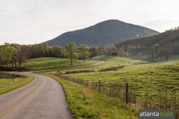
Mount Yonah


| ||||||
| Date(s) & Time: | Sun, Mar 6 2016 10:30 am >> Sun, Mar 6 2016 2:00 pm (Carpool Departure: 8:30 am *log in for location*) | ||||||
| Registration Opens: | Wed, Mar 2 2016 8:00 pm | ||||||
| Registration Cut Off: | Sat, Mar 5 2016 5:00 pm | ||||||
| Event Duration: | 3 Hours 30 Minutes | ||||||
| Difficulty Rating: | D3: Moderate (Exploratory) | ||||||
| Distance: | 5.5 Miles | ||||||
| Pace: | Moderate | ||||||
| Trip Leader(s): | Carol DaveO  Email Trip Leader(s) Email Trip Leader(s)
You must be logged in to get the Trip Leader contact information. | ||||||
| Member Cost: | None | ||||||
| Participant Info: | |||||||
| Who's Invited: | Members Only, 21 And Older Only | ||||||
| Maximum Group Size: | 16 | ||||||
| Minimum Group Size: | 4 | ||||||
| Number Registered So Far: | 14 / 0 (To see who's signed up, log in to the Member Area) | ||||||
| Are Dogs Permitted: | No | ||||||
|
Note: This is an "EXPLORATORY" trip. This means that there are parts of this trip, or perhaps the whole trip, that is new to your Trip Leader(s). However, they are confident that this will not be an issue. This note is here so that you can make an informed decision. When a Trip Leader isn't personally familiar with a trip, there is an increased chance of things not going as planned and you need to be prepared. The Trip Leader may have additional details in the itinerary. | |||||||
| Itinerary: | |||||||
Hiking Mount Yonah is always a great way to start your day. Yonah Mountain rises from the foothills of Georgia’s southern Appalachian Mountains, jutting skyward from the rolling landscape between Cleveland and Helen. The mountain’s asymmetrical shape and exposed rock ring near the summit make it a recognizable and iconic landmark in northern Georgia. Although the trail isn’t very long, it makes up for it with a steady incline of over 1466 feet in less than 2.5 miles. The Hike will start promptly at 10:30am. We will have lunch on the top of the mountain so we can enjoy the fantastic views. If the day is clear, we may be able to see the Atlanta skyline and Stone Mountain. We should be back at the Carpool around 3:30pm. This is definitely NOT a hike for beginners: this is considered a Hard D3 due to the elevation gain. Fluids are a must and don't forget to bring a lunch and snacks. There are restrooms at this location but you might want to stop before you get to the trail head. | |||||||
| |||||||
| How to Get There: | |||||||
| Event Directions: | From Mansell Park and Ride, continue on 400N to GA 115 in Lumpkin County. Continue on GA 115 appomimately 26 miles. Take a right to continue on GA 115 N/GA-52E. Continute straight for another 10.5 miles. Turn left onto Wilford Ash SR Parkway. Continue onto Bairsville Rd. Continue onto GA 75N. Take a R onto Tom Bell Rd. Right onto Chambers Rd which will lead us to the trail head. | ||||||
| Carpool to Event Distance (round trip): | 124Mile(s) | ||||||
| Carpool Departure Time: | 8:30 am | ||||||
| Carpool Location: | Log in for location | ||||||
| Carpool Directions: | Log in for directions | ||||||
| Carpool Cost: | Estimated cost per vehicle for this event is $49.60 using a reimbursement rate guideline of $0.400 per mile. The total amount should be divided by the number of people in the vehicle, including the driver. This is a guideline, not a rule, for drivers but the cost should not be higher unless there are extenuating circumstances. | ||||||
| Notes: | |||||||
|
* We encourage all members to follow our Etiquette Guidelines while participating in AOC events. | |||||||
Cancellation/Partial Attendance: Please review the AOC cancellation policy. | |||||||
 Calendar of Events
 Event Places