 Print-Friendly Version Print-Friendly Version
|
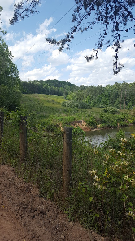
Saturday Adventure: Hike/ Explore Dawson Forest ( Carrpool 10am at Mansell Rd Park/ride) | |||||||
| The Basics: | |||||||
| Event Type: | Explorer | ||||||
| Event Location: |
Dawsonville, GA (carpool departure 10 am at Mansell Rd Park/Ride)


| ||||||
| Date(s) & Time: | Sat, May 14 2016 10:00 am >> Sat, May 14 2016 5:00 pm (Carpool Departure: 10:00 am *log in for location*) | ||||||
| Registration Opens: | Thu, May 12 2016 12:00 pm | ||||||
| Registration Cut Off: | Sat, May 14 2016 9:00 am | ||||||
| Event Duration: | 7 Hours | ||||||
| Difficulty Rating: | D5: Difficult (Exploratory) | ||||||
| Distance: | 12 Miles | ||||||
| Pace: | Fast | ||||||
| Trip Leader(s): | Erica B Email Trip Leader(s) Email Trip Leader(s)
You must be logged in to get the Trip Leader contact information. | ||||||
| Member Cost: | None | ||||||
| Participant Info: | |||||||
| Who's Invited: | Members Only, 21 And Older Only | ||||||
| Maximum Group Size: | 8 | ||||||
| Minimum Group Size: | 2 | ||||||
| Number Registered So Far: | 4 / 0 (To see who's signed up, log in to the Member Area) | ||||||
| Are Dogs Permitted: | No | ||||||
|
Note: This is an "EXPLORATORY" trip. This means that there are parts of this trip, or perhaps the whole trip, that is new to your Trip Leader(s). However, they are confident that this will not be an issue. This note is here so that you can make an informed decision. When a Trip Leader isn't personally familiar with a trip, there is an increased chance of things not going as planned and you need to be prepared. The Trip Leader may have additional details in the itinerary. | |||||||
| Itinerary: | |||||||
I have hiked this trail a couple of times and it was fun! The trail reminded me so much of some of the Tennessee Backwoods Trails that I grew-up hiking on. They are fun and challenging!!!! With this in mind, Saturday morning we will be exploring around 12 miles of trail at a fast pace with a few short breaks and 15 to 20 min for lunch. For those of you who have hiked with me before and those who would like to hike with me, I am thrilled to have other like minded or fun loving adventurers join me to hike! However, understand that I move fast with few breaks, because I want us to explore as much of the trail as possible in the time allocated for this event (10 am-11am travel to trail, 11:oo am-4pm hike 12miles of trail with a few breaks and 15 for lunch, 4 pm -5 travel back to park and ride). Keeping this in mind, here is some excellent information on Dawson Forest and the trail that Lauren J. provided for her event and co-lead with Joyce T. at Dawson Forest last year. Trail information from Lauren J.'s and Joyce T.'s hike at Dawson Forest
| |||||||
| |||||||
| How to Get There: | |||||||
| Event Directions: | Directions from Hwy 400: Take Hwy 400 North or South depending upon starting location to the Dawsonville Outlet mall Red Light. (Turn Left (West) if traveling North or Right (West) if traveling South onto Dawson Forest Road.) Go straight through roundabout, continue straight for approximately 4 miles until the intersection/stop sign. This is Highway 9. Proceed straight through intersection for approximately 1.5 miles to South entrance gate. Proceed through gate and Parking Area/Trailhead will be just ahead on the right. There is a brown sign at the road pointing to trail parking. Once you turn right, follow the road straight back and you will dead end in to a small parking area. There are several signs along the way indicating you are in Dawson Forest. | ||||||
| Carpool to Event Distance (round trip): | 60Mile(s) | ||||||
| Carpool Departure Time: | 10:00 am | ||||||
| Carpool Location: | Log in for location | ||||||
| Carpool Directions: | Log in for directions | ||||||
| Carpool Cost: | Estimated cost per vehicle for this event is $24.00 using a reimbursement rate guideline of $0.400 per mile. The total amount should be divided by the number of people in the vehicle, including the driver. This is a guideline, not a rule, for drivers but the cost should not be higher unless there are extenuating circumstances. | ||||||
| Notes: | |||||||
|
Be ready to explore, hike and have fun! * We encourage all members to follow our Etiquette Guidelines while participating in AOC events. | |||||||
| Cost Includes: | If you carpool bring gas money to give driver If you drive bring $5 incase there is paid parking at trailhead | ||||||
Cancellation/Partial Attendance: Please review the AOC cancellation policy. | |||||||
 Calendar of Events
 Event Places