 Print-Friendly Version Print-Friendly Version
|
|
Panther Creek Trail & Falls (Hike and Swim) | |||||||
| The Basics: | |||||||
| Event Type: | Hike | ||||||
| Event Location: |
Turnerville, GA


| ||||||
| Date(s) & Time: | Sat, Jul 9 2016 8:00 am >> Sat, Jul 9 2016 6:00 pm (Carpool Departure: 8:00 am *log in for location*) | ||||||
| Registration Opens: | Mon, Jun 27 2016 9:00 pm | ||||||
| Registration Cut Off: | Fri, Jul 8 2016 8:00 am | ||||||
| Event Duration: | 10 Hours | ||||||
| Difficulty Rating: | D5: Difficult | ||||||
| Distance: | 12 Miles | ||||||
| Pace: | Moderate | ||||||
| Trip Leader(s): | Lisa Aaron  Email Trip Leader(s) Email Trip Leader(s)
You must be logged in to get the Trip Leader contact information. | ||||||
| Member Cost: | None | ||||||
| Participant Info: | |||||||
| Who's Invited: | Members Only, 21 And Older Only | ||||||
| Maximum Group Size: | 14 | ||||||
| Minimum Group Size: | 4 | ||||||
| Number Registered So Far: | 11 / 0 (To see who's signed up, log in to the Member Area) | ||||||
| Are Dogs Permitted: | No | ||||||
| Itinerary: | |||||||
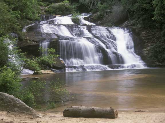
Let's savor a nice 12 mile hike through the woods, sprinkled with a dip or two in Panther Creek below the falls. First off will be a three and a half mile trek through lush old-growth forest. Mmm. Crossing a creek about half a mile in, we'll climb elevation and then drop up and down as the trail undulates through the trees. We'll hear waterfalls now and then along the way, crossing a couple of weathered wooden bridges and a section of trail precariously close to a steep drop-off. We will reach the sandy beach below Panther Creek Falls by bouldering down a rocky outcrop to our swimming hole. Here we'll cool off below the falls for a while, enjoying a snack and a bit of rest before moving on. Now most day hikers go only as far as the swimming hole before doubling back, but not us! We'll continue along the creek to the end of the line at Davidson Creek. Since this section of the trail is less traversed, it's a bit rough and we might well have to do some bushwhacking. Along with strenuous and technical climbs, we will encounter steep drop-offs from narrow ledges. There are a few guide-wires, just enough to make you miss them in dicey areas. This area of the trail is designated as a "Protected Botanical Area" by the U.S. Forest Service because of the beauty and diversity of its flora. From the end of the line we'll double back, stop for another refreshing and well-deserved plunge under the falls, and then haul ourselves back up the boulders to enjoy our walk back through the forest. THIS IS A PHYSICALLY AND MENTALLY CHALLENGING HIKE. If you have not had recent D4 or D5 experience with the AOC, your trip leaders will be contacting you. This hike will definitely include some steep ascents, sharp downhills, cliffs, steel cables, and gnarly roots. Total elevation gain 2000+.
| |||||||
| |||||||
| How to Get There: | |||||||
| Event Directions: | Will be given at carpool. | ||||||
| Carpool to Event Distance (round trip): | 150Mile(s) | ||||||
| Carpool Departure Time: | 8:00 am | ||||||
| Carpool Location: | Log in for location | ||||||
| Carpool Directions: | Log in for directions | ||||||
| Carpool Cost: | Estimated cost per vehicle for this event is $60.00 using a reimbursement rate guideline of $0.400 per mile. The total amount should be divided by the number of people in the vehicle, including the driver. This is a guideline, not a rule, for drivers but the cost should not be higher unless there are extenuating circumstances. | ||||||
| Notes: | |||||||
|
* We encourage all members to follow our Etiquette Guidelines while participating in AOC events. | |||||||
Cancellation/Partial Attendance: Please review the AOC cancellation policy. | |||||||
 Calendar of Events
 Event Places