 Print-Friendly Version Print-Friendly Version
|
|
High Falls Backpacking with optional standing Indian hike | |||||||
| The Basics: | |||||||
| Event Type: | Backpacking | ||||||
| Event Location: | Beech Creek/Big Scaly Area, North Carolina | ||||||
| Date(s) & Time: | Sat, Jul 16 2016 7:30 am >> Sun, Jul 17 2016 5:13 pm (Carpool Departure: 7:30 am *log in for location*) | ||||||
| Registration Opens: | Thu, Jun 30 2016 8:30 pm | ||||||
| Registration Cut Off: | Fri, Jul 15 2016 3:00 pm | ||||||
| Event Duration: | 1 Days 9 Hours 43 Minutes | ||||||
| Difficulty Rating: | D4: Moderate to Difficult (Exploratory) | ||||||
| Distance: | 10 Miles | ||||||
| Pace: | Moderate | ||||||
| Trip Leader(s): | Fardis Mike Pawloski  Email Trip Leader(s) Email Trip Leader(s)
You must be logged in to get the Trip Leader contact information. | ||||||
| Member Cost: | None | ||||||
| Participant Info: | |||||||
| Who's Invited: | Members Only, 21 And Older Only | ||||||
| Maximum Group Size: | 8 | ||||||
| Minimum Group Size: | 3 | ||||||
| Number Registered So Far: | 9 / 0 (To see who's signed up, log in to the Member Area) | ||||||
| Are Dogs Permitted: | Yes | ||||||
|
Note: This is an "EXPLORATORY" trip. This means that there are parts of this trip, or perhaps the whole trip, that is new to your Trip Leader(s). However, they are confident that this will not be an issue. This note is here so that you can make an informed decision. When a Trip Leader isn't personally familiar with a trip, there is an increased chance of things not going as planned and you need to be prepared. The Trip Leader may have additional details in the itinerary. | |||||||
| Itinerary: | |||||||
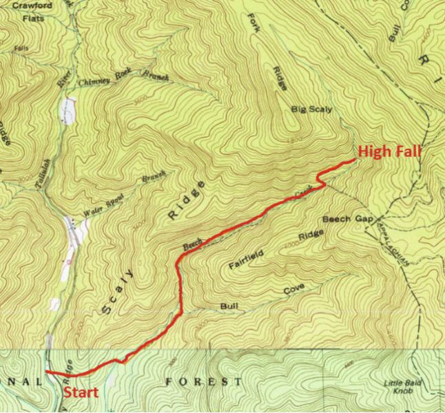
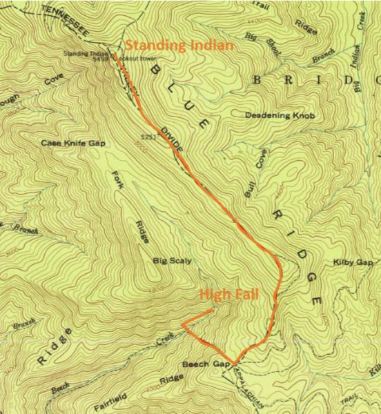
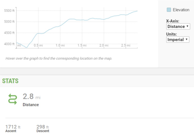
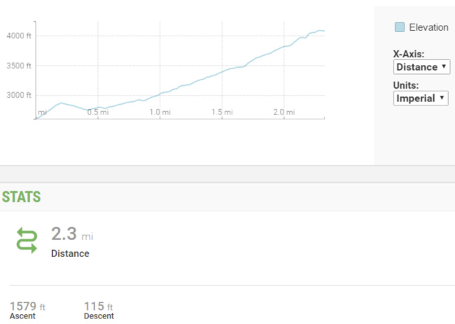
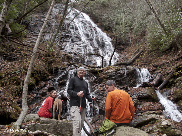
High Falls is a gorgeous fall (about 200 ft) located below Big Scaly and near Standing Indian Mountain. This is a great opportunity to see and enjoy its beauty and surroundings. Also if you want you can hike to Standing Indian summit (5,499 ft). The total distance hiked can vary between 4.6 to 10.5 miles. From the trail head to High Falls camp site is 2.3 miles one way. From camp site to Standing Indian is 2.8 miles. Total driving distance is around 210 miles round trip with a driving time around 2 hours each way. First Day: After setting up camp and gathering firewood, we have some options - --Stay at the camp site, relax and enjoy the wilderness, cold water and camp fire. --Or hike to Standing Indian and back. This is a strenuous 5.8 round trip hike. There is a connector trail that connects Beech Greek to Appalachian Trail. This connector is very steep (quarter of a mile and 630 ft accent which makes it a 45% sloop or 25 degree of inclination). After getting to Appalachian Trail, it is a straght-forward 2.3 hike with 1000 ft accent to Standing Indian summit. See second map below. Fardis will be leading this. --Or hike to Big Scaly over look and back, about a 4 1/2 mile round trip. This option will remain on the main trail to Case Knife Gap, and cut over approx 1 mile to the overlook. This is a great view. No map for this option. Second Day: After having breakfast we will pack up and around 10 we will follow the same path back to our cars. I recommend that you start with at least 1.5 liter of water. There will be water source around camp site so you can refill.
Up to two dogs allowed on this Event. Be aware that is going to be very hot and I don’t want to see them get heatstroke. So don’t forget to bring a lot for water for them. We are up for stopping on the way back for lunch in Clayton. If you prefer not to, arrange this at the carpool on Saturday morning, and bring enough food to sustain you until later Sunday afternoon.
| |||||||
| |||||||
| How to Get There: | |||||||
| Event Directions: | Directions to trailhead will be given at carpool (or print your own: https://goo.gl/maps/U5hM9kKa Aq22). GPS: Tate City, Georgia 34.9953461, -83.5561566 | ||||||
| Carpool to Event Distance (round trip): | 210Mile(s) | ||||||
| Carpool Departure Time: | 7:30 am | ||||||
| Carpool Location: | Log in for location | ||||||
| Carpool Directions: | Log in for directions | ||||||
| Carpool Cost: | Estimated cost per vehicle for this event is $84.00 using a reimbursement rate guideline of $0.400 per mile. The total amount should be divided by the number of people in the vehicle, including the driver. This is a guideline, not a rule, for drivers but the cost should not be higher unless there are extenuating circumstances. | ||||||
| Notes: | |||||||
|
* We encourage all members to follow our Etiquette Guidelines while participating in AOC events. | |||||||
Cancellation/Partial Attendance: Please review the AOC cancellation policy. | |||||||
 Calendar of Events
 Event Places