 Print-Friendly Version Print-Friendly Version
|
|
New trails at Sawnee Mountain | |||||||
| The Basics: | |||||||
| Event Type: | Hike | ||||||
| Event Location: |
Cumming, GA


| ||||||
| Date(s) & Time: | Sun, Jul 10 2016 9:00 am >> Sun, Jul 10 2016 11:30 am | ||||||
| Registration Opens: | Wed, Jul 6 2016 9:00 pm | ||||||
| Registration Cut Off: | Sat, Jul 9 2016 6:00 pm | ||||||
| Event Duration: | 2 Hours 30 Minutes | ||||||
| Difficulty Rating: | D3: Moderate | ||||||
| Distance: | 5.1 Miles | ||||||
| Pace: | Moderate | ||||||
| Trip Leader(s): | Lauren Email Trip Leader(s) Email Trip Leader(s)
You must be logged in to get the Trip Leader contact information. | ||||||
| Member Cost: | None | ||||||
| Participant Info: | |||||||
| Who's Invited: | Members Only, 21 And Older Only | ||||||
| Maximum Group Size: | 9 | ||||||
| Minimum Group Size: | 4 | ||||||
| Number Registered So Far: | 7 / 0 (To see who's signed up, log in to the Member Area) | ||||||
| Are Dogs Permitted: | No | ||||||
| Itinerary: | |||||||
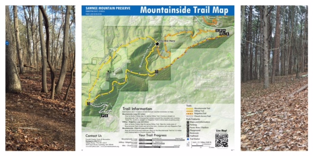
There are just over seven new miles of trails out at Sawnee Mountain Preserve. We plan on doing the loop which includes the Hilltop Trail, Mountainside Trail and Ridgeline Trail. The hike will be just over 5 miles. We will start on time. This is not a beginner hike. We will be moving at a moderate pace with a minimum number of stops to gather up. We will pause about halfway through the hike for 10 or 15 minutes to enjoy one of the summits, so bring a small snack if you would like. There is a surprising amount of elevation gain. There are lots of undulations and the scenery is very pretty. It's easy to get lost in the woods so close to home.
Lat/lon: 34.243559, -84.139470
Link to trail map:
http://documents.atlantaregional.com/gisdocs/ARGIS_Poster_Forsyth_Saw
nee_100815.pdf | |||||||
| |||||||
| How to Get There: | |||||||
| Event Directions: | Open maps.google.com and paste the bold text in to the search bar. Then chose Satellite view for a bird's eye view Lat/lon: 34.243559, -84.139470 OR 2500 Bettis Tribble Gap Rd, Cumming GA 400 to exit 15 (Bald Ridge Rd), go west towards downtown Cumming As you come through downtown Cumming, you will cross Hwy 9. The next right is Tribble Gap Rd. (same as Bettis Tribble Gap). Right on Tribble Gap Rd and go about three miles and you will see entrances to Sawnee Mountain on each side of the road. Take the entrance on the left, come up the hill and you'll see parking. If you come to a traffic light at Spot Rd, you have gone too far. | ||||||
| Notes: | |||||||
|
Sorry, no dogs are allowed at this park.
* We encourage all members to follow our Etiquette Guidelines while participating in AOC events. | |||||||
Cancellation/Partial Attendance: Please review the AOC cancellation policy. | |||||||
 Calendar of Events
 Event Places