 Print-Friendly Version Print-Friendly Version
|
|
Unicoi Gap to Tray Mountain Shelter | |||||||
| The Basics: | |||||||
| Event Type: | Hike | ||||||
| Event Location: |
Appalachian Trail Unicoi Gap


| ||||||
| Date(s) & Time: | Sat, Aug 13 2016 8:00 am >> Sat, Aug 13 2016 6:00 pm (Carpool Departure: 8:00 am *log in for location*) | ||||||
| Registration Opens: | Wed, Aug 3 2016 9:00 pm | ||||||
| Registration Cut Off: | Fri, Aug 12 2016 9:00 pm | ||||||
| Event Duration: | Per Itinerary | ||||||
| Difficulty Rating: | D5: Difficult | ||||||
| Distance: | 11 Miles | ||||||
| Pace: | Moderate | ||||||
| Trip Leader(s): | Aaron Email Trip Leader(s) Email Trip Leader(s)
You must be logged in to get the Trip Leader contact information. | ||||||
| Member Cost: | None | ||||||
| Participant Info: | |||||||
| Who's Invited: | Members Only, 21 And Older Only | ||||||
| Maximum Group Size: | 12 | ||||||
| Minimum Group Size: | 4 | ||||||
| Number Registered So Far: | 14 / 0 (To see who's signed up, log in to the Member Area) | ||||||
| Are Dogs Permitted: | Yes | ||||||
| Itinerary: | |||||||
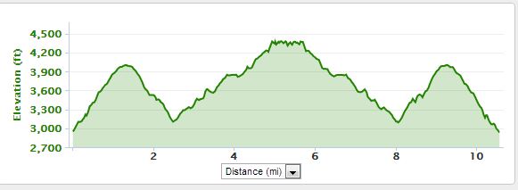
Come and join us on a fun hike to the top of Tray Mountain and then down to Tray Mountain shelter. Tray Mountain is Georgia's 7th highest, offering great views of the surrounding countryside and on a clear day Mount Yonah! This will be a strenuous hike with approximately 3500 feet of elevation gain. We will begin by ascending Rocky Mtn (just over 1100 feet elevation gain) and then descend into Inidan Grave Gap before we make the final push to the top of Tray Mountain, an additional 1400 feet of elevation gain, after taking a short rest we will continue on to Tray Mountain shelter where we will stop and eat lunch. On the way back we will have one final ascent back up Rocky Mtn before descending back to the cars. On the way back we will take a short hike to explore the overlook for an excellent view. If you have not recently completed a D5 event with the AOC I will contact you to see if this event is appropriate for you. Elevation profile:
The event will go ahead rain or shine but not in severe weather.
| |||||||
| |||||||
| How to Get There: | |||||||
| Event Directions: | North on GA 400 from the park and ride. When GA 400 ends
at Chevron station. continue on GA 115. Go 4.8 miles where GA 115
meets GA 52. Turn right. Continue on GA 115 until Cleveland GA. At
traffic circle in Cleveland go north on US 129. | ||||||
| Carpool to Event Distance (round trip): | 140Mile(s) | ||||||
| Carpool Departure Time: | 8:00 am | ||||||
| Carpool Location: | Log in for location | ||||||
| Carpool Directions: | Log in for directions | ||||||
| Carpool Cost: | Estimated cost per vehicle for this event is $56.00 using a reimbursement rate guideline of $0.400 per mile. The total amount should be divided by the number of people in the vehicle, including the driver. This is a guideline, not a rule, for drivers but the cost should not be higher unless there are extenuating circumstances. | ||||||
| Notes: | |||||||
|
* We encourage all members to follow our Etiquette Guidelines while participating in AOC events. | |||||||
Cancellation/Partial Attendance: Please review the AOC cancellation policy. | |||||||
 Calendar of Events
 Event Places