 Print-Friendly Version Print-Friendly Version
|
|
CRNRA BOWMANS ISLAND UNIT | |||||||
| The Basics: | |||||||
| Event Type: | Hike | ||||||
| Event Location: |
CUMMING, GA


| ||||||
| Date(s) & Time: | Sat, Sep 3 2016 8:30 am >> Sat, Sep 3 2016 11:00 am | ||||||
| Registration Opens: | Tue, Aug 30 2016 8:00 pm | ||||||
| Registration Cut Off: | Fri, Sep 2 2016 10:00 pm | ||||||
| Event Duration: | 2 Hours 30 Minutes | ||||||
| Difficulty Rating: | D2: Easy to Moderate (Exploratory) | ||||||
| Distance: | 5 Miles | ||||||
| Pace: | Moderate | ||||||
| Trip Leader(s): | Diana Email Trip Leader(s) Email Trip Leader(s)
You must be logged in to get the Trip Leader contact information. | ||||||
| Member Cost: | None | ||||||
| Participant Info: | |||||||
| Who's Invited: | Members Only, 21 And Older Only | ||||||
| Maximum Group Size: | 10 | ||||||
| Minimum Group Size: | 4 | ||||||
| Number Registered So Far: | 7 / 0 (To see who's signed up, log in to the Member Area) | ||||||
| Are Dogs Permitted: | No | ||||||
|
Note: This is an "EXPLORATORY" trip. This means that there are parts of this trip, or perhaps the whole trip, that is new to your Trip Leader(s). However, they are confident that this will not be an issue. This note is here so that you can make an informed decision. When a Trip Leader isn't personally familiar with a trip, there is an increased chance of things not going as planned and you need to be prepared. The Trip Leader may have additional details in the itinerary. | |||||||
| Itinerary: | |||||||
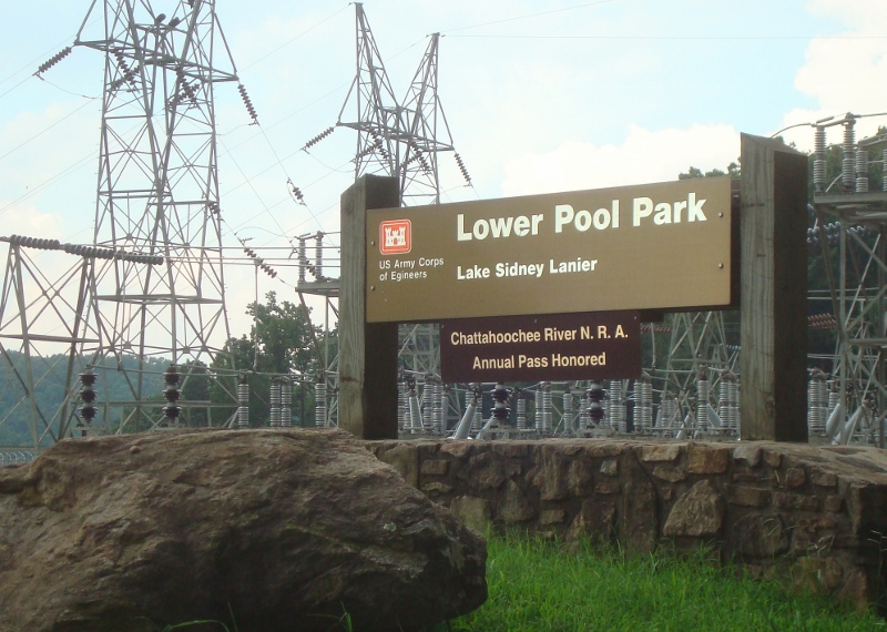
5 MILE HIKE FROM LOWER POOL WEST PARK TO BUFORD TROUT HATCHERY AND RETURN TO LOWER POOL WEST PARK We’ll start our hike promptly at 8:30am. Please arrive a few minutes early to ensure you have a parking pass, utilize the toilets, and meet your fellow hikers. We will begin our hike where the Chattahoochee River is released from the south side of Lake Lanier. We’ll walk at a moderate pace (about 2.5 mph) through some forest hills and along the river and make our way down to the Buford Trout Hatchery. Here we’ll take a few minutes to check out the fish and utilize the toilets, if they are available. If time allows we will walk the Hatchery nature trail to get a bit more mileage. We will return to Lower Pool West Park repeating much of the trail we used to get to the Hatchery. Highlights of the hike include: varied terrain/environment (dry hills, ridges, lush flats by River), water features (creeks, River), fish hatchery, wildlife (deer often sighted). We will meet in the parking lot of Lake Lanier’s “Lower Pool West Park” site, not to be confused with either “Lower Pool East” or “Lower Overlook”. Lower Pool West Park is immediately below/south of the lake at the dam, on the west side of the river. Lower Pool West Park is accessed from Buford Dam Road via “Lower Pool Road”. On the north side of Buford Dam Road is a street sign for “Lower Pool Road”. The approximate latitude/longitude for the turnoff from Buford Dam Road into the park are: N 34.16284 W 84.07703. The entrance does not look like a park entrance. As you turn onto Lower Pool Road you’ll see substantial utility station equipment. But, you’ll also see a sign welcoming you to the park. WARNING: MAPS MAY SUGGEST THAT THIS ROAD IS CALLED “LITTLE MILL ROAD”. YOU ARE ADVISED NOT TO ASK YOUR GPS TOOL FOR DIRECTIONS TO LITTLE MILL ROAD. MOST GPS APPS SHOULD ACCEPT A REQUEST FOR DIRECTIONS TO LOWER POOL WEST PARK. Shortly after turning onto “Lower Pool Road” you will encounter a kiosk at which you can purchase a Corps of Engineers parking pass for $5. Alternatively, you can display your current Chattahoochee River National Recreation Area pass. Drive down the road. We’ll meet in the first parking lot, on your right. There are restrooms “around the bend” from our meeting point, maybe 50 yards beyond the parking lot we’ll be using. There are also restrooms at the ~ ˝ way point, though no assurance that these will be open. | |||||||
| |||||||
| How to Get There: | |||||||
| Event Directions: | If any trouble finding the LOWER POOL parking area call me - DIANA 678- 759-9732 From GA 400, driving North from points South of GA-400/GA-20: Take exit #14, Buford Hwy/GA-20Head East on GA-20At ~ .5 miles, turn LEFT/NE onto Sanders RoadFollow Sanders Rd for ~ .8 milesTurn RIGHT/EAST onto Buford Dam RoadFollow Buford Dam Road EAST, then SE for ~ 3.7 milesTurn RIGHT Lower Pool RoadThis road is IMMEDIATELY before the dam where the River is released. This road looks like the WRONG place to turn; it doesn’t look like you are entering a park. You’ll see utility facilities as you enter. Follow Lower Pool Road, downhill, for ~ .7 miles.En route you will pass a park kiosk where you can purchase a Corps of Engineers parking pass. Park your vehicle at the “bottom” of the road, in the parking lot on the right. The restrooms are about 50 yards further along. From GA 400, driving South from points North of GA- 400/GA-20:Take exit #15, Bald Ridge Marina Rd.Head East on Bald Ridge Road At ~ .3 miles, turn RIGHT onto Turner RoadFollow Turner Rd for ~ .2 milesTurn RIGHT/SOUTH onto Market Place BlvdFollow Market Place Blvd for ~ 1.4 milesTurn LEFT onto Buford Dam Road Follow Buford Dam Road EAST then SE for ~ 4.3 milesTurn RIGHT onto Lower Pool Road This road is IMMEDIATELY before the dam where the River is released.This road looks like the WRONG place to turn; it doesn’t look like you are entering a park. You’ll see utility facilities when you enter.Follow Lower Pool Road, downhill, for ~ .7 miles.En route you will pass a park kiosk where you can purchase a Corps of Engineers parking pass. Park your vehicle at the “bottom” of the road, in the parking lot on the right. The restrooms are about 50 yards further along. From I-85, driving North from points South of Lake Lanier:Take exit #113, I-985Follow I-985 for ~ 3.5 miles, then take Exit #4, GA-20/US-23S At the exit, turn LEFT and follow GA- 20 W/NW for ~ 3.3 miles Turn RIGHT onto Sycamore RoadFollow Sycamore Road NORTH for ~ 2.6 miles Turn LEFT onto Buford Dam RoadFollow Buford Dam Road N/NW for ~ 2.3 miles Lake Lanier will be on your right Immediately after you cross over the dam out of which the River, emergesTurn LEFT onto Lower Pool RoadThis road is IMMEDIATELY after the dam where the River is released. This road looks like the WRONG place to turn; it doesn’t look like you are entering a park. You’ll see utility facilities upon entering. Follow Lower Pool Road, downhill, for ~ .7 miles.En route you will pass a park kiosk where you can purchase a Corps of Engineers parking pass. Park your vehicle at the “bottom” of the road, in the parking lot on the right. The restrooms are about 50 yards further along. | ||||||
| Notes: | |||||||
|
* We encourage all members to follow our Etiquette Guidelines while participating in AOC events. | |||||||
Cancellation/Partial Attendance: Please review the AOC cancellation policy. | |||||||
 Calendar of Events
 Event Places