 Print-Friendly Version Print-Friendly Version
|
Backpack to Slickrock Creek in Joyce Kilmer-Slickrock Wilderness | |||||||
| The Basics: | |||||||
| Event Type: | Backpacking | ||||||
| Event Location: |
Joyce Kilmer-Slickrock Wilderness


| ||||||
| Date(s) & Time: | Sat, Oct 8 2016 7:30 am >> Sun, Oct 9 2016 6:00 pm (Carpool Departure: 7:30 am *log in for location*) | ||||||
| Registration Opens: | Tue, Sep 20 2016 7:00 pm | ||||||
| Registration Cut Off: | Thu, Oct 6 2016 8:00 pm | ||||||
| Event Duration: | 1 Days 10 Hours 30 Minutes | ||||||
| Difficulty Rating: | D4: Moderate to Difficult | ||||||
| Distance: | 6 Miles | ||||||
| Pace: | Moderate | ||||||
| Trip Leader(s): | Michael J Jenny  Email Trip Leader(s) Email Trip Leader(s)
You must be logged in to get the Trip Leader contact information. | ||||||
| Member Cost: | None | ||||||
| Participant Info: | |||||||
| Who's Invited: | Members Only, 21 And Older Only | ||||||
| Maximum Group Size: | 12 | ||||||
| Minimum Group Size: | 3 | ||||||
| Number Registered So Far: | 12 / 0 (To see who's signed up, log in to the Member Area) | ||||||
| Are Dogs Permitted: | Yes | ||||||
| Itinerary: | |||||||
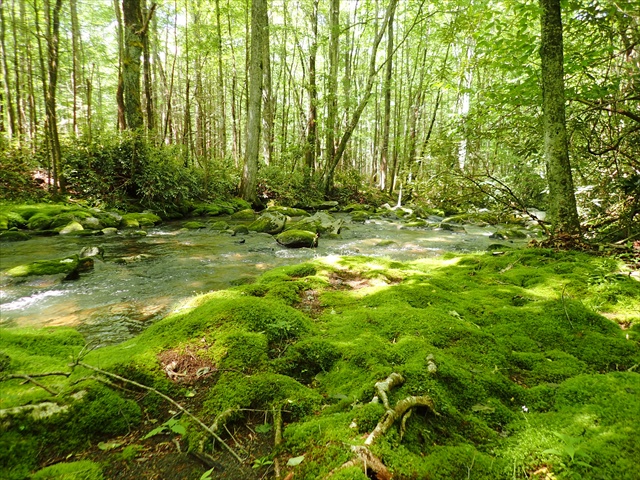
The United States Congress designated the Joyce Kilmer-Slickrock Wilderness in 1975 and it now has a total of 17,394 acres. North Carolina contains approximately 13,562 acres. Tennessee contains approximately 3,832 acres. It is managed by the Forest Service. The Joyce Kilmer-Slickrock Wilderness is bordered by the Citico Creek Wilderness to the west. From Big Fat Gap, we will hike about 3 miles, loosing 1000' in the first 1.5 miles so it's relatively steep in places, down to Slickrock creek. We will make a couple of river crossings, before we get to camp near Wildcat Falls. I recommend having water shoes for these two crossings, and for possible ventures along and across Slickrock creek after setting up camp.
On Sunday, we should break camp after a late breakfast and be on the trail by 11am. The weather could force us to leave a little earlier, but we'll discuss that on Saturday night. I love the mornings in the mountains, so it would have to be bad weather, like fog or rain to push us out earlier.
NOTE: We will allow a maximum of two well behaved dogs on this trip. See additional notes below.
| |||||||
| |||||||
| How to Get There: | |||||||
| Event Directions: | Directions TO the event: https://goo.gl/maps/nkEJe3cvYBL2
| ||||||
| Carpool to Event Distance (round trip): | 320Mile(s) | ||||||
| Carpool Departure Time: | 7:30 am | ||||||
| Carpool Location: | Log in for location | ||||||
| Carpool Directions: | Log in for directions | ||||||
| Carpool Cost: | Estimated cost per vehicle for this event is $128.00 using a reimbursement rate guideline of $0.400 per mile. The total amount should be divided by the number of people in the vehicle, including the driver. This is a guideline, not a rule, for drivers but the cost should not be higher unless there are extenuating circumstances. | ||||||
| Notes: | |||||||
|
There is a limit of two dogs on this trip. They must be well trained and get along with both people and other dogs. Please contact Michael J. if you plan to bring a dog. * We encourage all members to follow our Etiquette Guidelines while participating in AOC events. | |||||||
Cancellation/Partial Attendance: Please review the AOC cancellation policy. | |||||||
 Calendar of Events
 Event Places