 Print-Friendly Version Print-Friendly Version
|
|
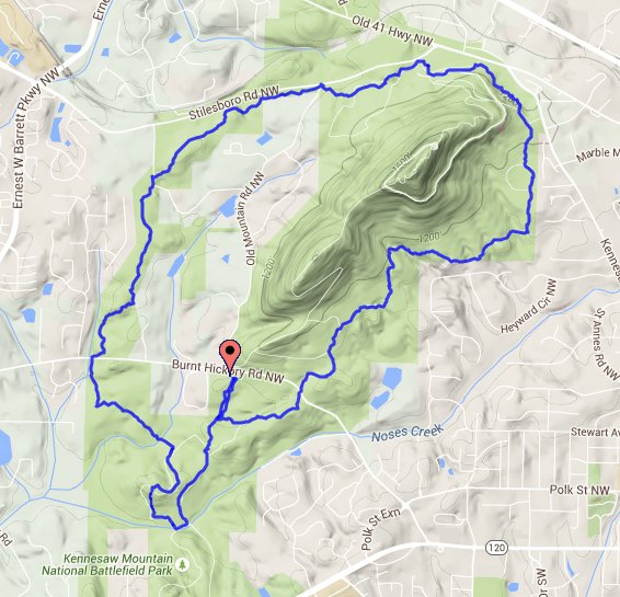
Kennesaw Mountain Hike, 8.5-mile loop around the mountain | |||||||
| The Basics: | |||||||
| Event Type: | Hike | ||||||
| Event Location: |
Kennesaw Mountain, Burnt Hickory parking lot


| ||||||
| Date(s) & Time: | Sun, Sep 18 2016 8:00 am >> Sun, Sep 18 2016 11:00 am | ||||||
| Registration Opens: | Fri, Sep 16 2016 10:00 pm | ||||||
| Registration Cut Off: | Sun, Sep 18 2016 9:00 am | ||||||
| Event Duration: | 3 Hours | ||||||
| Difficulty Rating: | D3: Moderate | ||||||
| Distance: | 8.5 Miles | ||||||
| Pace: | Moderate | ||||||
| Trip Leader(s): | Adel Email Trip Leader(s) Email Trip Leader(s)
You must be logged in to get the Trip Leader contact information. | ||||||
| Member Cost: | None | ||||||
| Participant Info: | |||||||
| Who's Invited: | Members Only, 21 And Older Only | ||||||
| Maximum Group Size: | 12 | ||||||
| Minimum Group Size: | 2 | ||||||
| Number Registered So Far: | 11 / 0 (To see who's signed up, log in to the Member Area) | ||||||
| Are Dogs Permitted: | Yes | ||||||
| Itinerary: | |||||||
We will hike together as one group on this hike. Parking will be at Burnt Hickory parking lot, and we will meet next to the water fountain. Parking is limited, so please arrive at least 15 minutes early to secure a parking spot so we can start on time. We will be hiking an 8.5-mile counter- clockwise loop around Kennesaw Mountain with a total elevation gain of about 500 feet, starting at the Burnt Hickory parking lot. We will hike at an average pace of 3 mph and keep the group together. If needed, we will stop at intersections and road crossings to regroup. This hike will NOT include hiking to the top of Kennesaw Mountain. We will only be hiking around the mountain. We will first head south for a short
distance to get to the start of the loop. From
there, we will begin our loop by heading east
and crossing Burnt Hickory Road to take the
Camp Brumby (AKA East Trail) trail to the
Visitor's Center, where we will take a quick
break. After our break, we will head to the
Environmental Trail, which will take us to the
24 Gun Trail, and continue our loop on the west
side of the mountain. The west part of the loop
will include crossing Old Mountain road and
Gilbert road, and will eventually take us to
another crossing on Burnt Hickory Road. This
will take us to the last part of the loop. Our
general direction on this part will be south,
until we get to Noses Creek, and we will then
turn north to get back to where we parked. | |||||||
| |||||||
| How to Get There: | |||||||
| Event Directions: | Burnt Hickory Parking Lot Address: 1521 Burnt Hickory Road Northwest, Marietta, GA 30064 GPS coordinates:
33.963415, -84.594999 Directions: Going north on I-75 near
Marietta, take exit 263 (120 South Loop towards
Southern Polytechnic and Marietta). Follow the
120 South Loop west for about 3 miles to
Whitlock Ave. The "loop" makes a hard right
after you cross under the tracks (but you can't
miss it). Then turn left (west) on Whitlock
Ave and go about 2.5 more miles. (Whitlock
Ave is also known as GA Hwy 120 and Dallas
Hwy.) Turn right (north) on Burnt Hickory
Road and go about 1.3 miles. The parking lot
is on the left. | ||||||
| Notes: | |||||||
|
* We encourage all members to follow our Etiquette Guidelines while participating in AOC events. | |||||||
Cancellation/Partial Attendance: Please review the AOC cancellation policy. *Note: To get credit for the hike, you must complete the entire hike. | |||||||
 Calendar of Events
 Event Places