 Print-Friendly Version Print-Friendly Version
|
|
Black Rock Mountain State Park | |||||||
| The Basics: | |||||||
| Event Type: | Hike | ||||||
| Event Location: |
Mountain City, GA


| ||||||
| Date(s) & Time: | Sat, Oct 1 2016 8:30 am >> Sat, Oct 1 2016 8:30 pm (Carpool Departure: 8:30 am *log in for location*) | ||||||
| Registration Opens: | Mon, Sep 26 2016 8:00 pm | ||||||
| Registration Cut Off: | Fri, Sep 30 2016 6:00 pm | ||||||
| Event Duration: | per itinerary | ||||||
| Difficulty Rating: | D5: Difficult | ||||||
| Distance: | 10 Miles | ||||||
| Pace: | Moderate | ||||||
| Trip Leader(s): | Dorothea Ann  Email Trip Leader(s) Email Trip Leader(s)
You must be logged in to get the Trip Leader contact information. | ||||||
| Member Cost: | None | ||||||
| Participant Info: | |||||||
| Who's Invited: | Members Only, 21 And Older Only | ||||||
| Maximum Group Size: | 9 | ||||||
| Minimum Group Size: | 2 | ||||||
| Number Registered So Far: | 12 / 0 (To see who's signed up, log in to the Member Area) | ||||||
| Are Dogs Permitted: | No | ||||||
| Itinerary: | |||||||
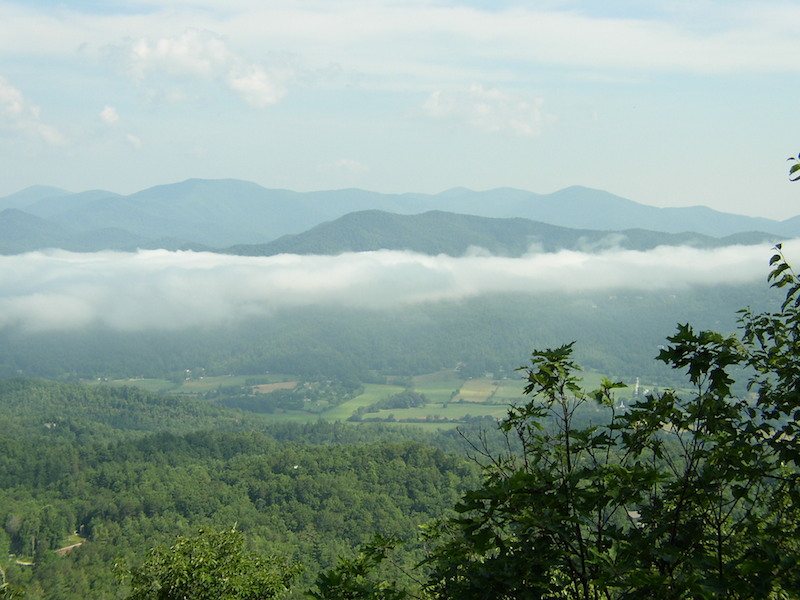
The hike is comprised of three trails (1) James E Edmond Backcountry Trail 7.2 miles, (2) Tennessee Rock Trail 2.2 miles, (3) Black Rock Lake Trail .8 miles. This set of trails, the way the AOC usually hikes it, has wiped out at least one hiker if not also a trip leader every time I have hiked it in a group, so I propose to hike it somewhat differently. We'll do the steep climb at the beginning of the hike and end by going downhill. To do this we will start at the reservoir, hike around it to warm up, then climb up the James Edmond B. Trail to its trailhead, continue counterclockwise round the Tennessee Rock Trail to the lookout (pictured), before rejoining the James Edmond B Trail and taking the other spur to complete the loop (with the second lookout), and then descending to the cars. We will park in the parking lot beside the reservoir. With 3000 ft elevation gain and a distance of 10.2 miles this hike qualifies as a D5, which is how I have rated it mainly because of the steep grades. Ann will coordinate the carpool at Indian Trail park-and-ride, and I'll be joining the group at 9:45 at the Clayton Ingles. I would like to have dinner in Clayton after the hike. If you cannot stay for dinner, you should consider driving separately as far as the Ingles ("meet at event"), where you can join the carpool to the trailhead. | |||||||
| |||||||
| How to Get There: | |||||||
| Event Directions: | From the Indian Trail park & ride, take I-85 North. After 11 miles bear left to take I-985 North. This road will change to GA 365, US 441, and US 23. Stay on it for 75 miles, then stop at the Ingles in Clayton. | ||||||
| Carpool to Event Distance (round trip): | 182Mile(s) | ||||||
| Carpool Departure Time: | 8:30 am | ||||||
| Carpool Location: | Log in for location | ||||||
| Carpool Directions: | Log in for directions | ||||||
| Carpool Cost: | Estimated cost per vehicle for this event is $72.80 using a reimbursement rate guideline of $0.400 per mile. The total amount should be divided by the number of people in the vehicle, including the driver. This is a guideline, not a rule, for drivers but the cost should not be higher unless there are extenuating circumstances. | ||||||
| Notes: | |||||||
|
If you are not an experienced hiker, or do not have previous D4 and D5 experience, this hike will be too strenuous for you. I will contact hikers who do not have recent D4 and D5 experience to determine if this hike is suitable for you. This is for the safety of the individual hiker and to ensure the entire group can maintain an appropriate pace. * We encourage all members to follow our Etiquette Guidelines while participating in AOC events. | |||||||
Cancellation/Partial Attendance: Please review the AOC cancellation policy. | |||||||
 Calendar of Events
 Event Places