 Print-Friendly Version Print-Friendly Version
|
|
Big Scaly and Standing Indian | |||||||
| The Basics: | |||||||
| Event Type: | Hike | ||||||
| Event Location: |
Big Scaly Ridge & Standing Indian


| ||||||
| Date(s) & Time: | Sat, Oct 29 2016 8:00 am >> Sat, Oct 29 2016 8:00 pm (Carpool Departure: 8:00 am *log in for location*) | ||||||
| Registration Opens: | Mon, Oct 24 2016 7:00 pm | ||||||
| Registration Cut Off: | Fri, Oct 28 2016 3:00 pm | ||||||
| Event Duration: | 12 Hours | ||||||
| Difficulty Rating: | D5: Difficult | ||||||
| Distance: | 12 Miles | ||||||
| Pace: | Moderate | ||||||
| Trip Leader(s): | Michael J Ryan  Email Trip Leader(s) Email Trip Leader(s)
You must be logged in to get the Trip Leader contact information. | ||||||
| Member Cost: | None | ||||||
| Participant Info: | |||||||
| Who's Invited: | Members Only, 21 And Older Only | ||||||
| Maximum Group Size: | 8 | ||||||
| Minimum Group Size: | 2 | ||||||
| Number Registered So Far: | 6 / 0 (To see who's signed up, log in to the Member Area) | ||||||
| Are Dogs Permitted: | No | ||||||
| Itinerary: | |||||||
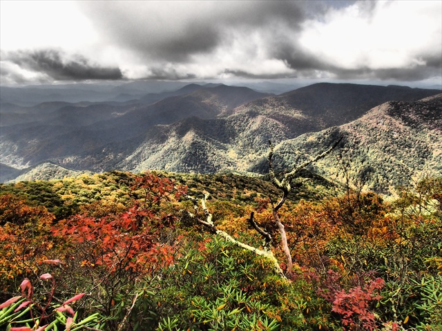
Some of the most scenic mountain vistas I've enjoyed in the SE are in the Southern Nantahala's from both Big Scaly Ridge and Standing Indian. Hopefully we'll time it just right to get some nice colors up there this weekend. We were near that area on 10/22 and the colors were just starting to turn. We'll start at 2800' elevation, and climb up to Standing Indian at 5500' elevation, but because we'll go back down to Case Knife Gap from Big Scaly Ridge, the total elevation gain will be right around 3000'. The picture above was taken by me from Big Scaly ridge last fall. From the trail head at the end of Tallulah River road, we will climb up Chimney Rock trail to Case Knife Gap. We will wait for everyone to regroup here, then go up the ridge to Big Scaly Ridge and hopefully enjoy some great fall colors. After we hang out here for a little while, we'll go back down to Case Knife Gap, then go up the very steep and sometimes hard to follow connector trail to the A.T. We'll wait for everyone here again, then go on up to Standing Indian for lunch. After we finish here, spending a little time enjoying the view after lunch and taking pictures, we'll continue on the A.T. to Deep Gap. Again regroup, then head on down the very steep Deep Gap Branch trail to our cars. This hike is over 3k' elevation change and around 12 miles, so it's only for very fit hikers. With the added challenge of fallen leaves on the trail, and the steepness of the trail, especially on the way down, you will not only need to be fit enough, but be light of foot right up to the end. We won't be racing, but we will need to continue a moderate pace to get off the trail before it's dark as the days grow shorter. | |||||||
| |||||||
| How to Get There: | |||||||
| Carpool to Event Distance (round trip): | 210Mile(s) | ||||||
| Carpool Departure Time: | 8:00 am | ||||||
| Carpool Location: | Log in for location | ||||||
| Carpool Directions: | Log in for directions | ||||||
| Carpool Cost: | Estimated cost per vehicle for this event is $84.00 using a reimbursement rate guideline of $0.400 per mile. The total amount should be divided by the number of people in the vehicle, including the driver. This is a guideline, not a rule, for drivers but the cost should not be higher unless there are extenuating circumstances. | ||||||
| Notes: | |||||||
|
* We encourage all members to follow our Etiquette Guidelines while participating in AOC events. | |||||||
Cancellation/Partial Attendance: Please review the AOC cancellation policy. | |||||||
 Calendar of Events
 Event Places