 Print-Friendly Version Print-Friendly Version
|
|
Longleaf and Big Poplar Loops at FD Roosevelt State Park | |||||||
| The Basics: | |||||||
| Event Type: | Hike | ||||||
| Event Location: |
FD Roosevelt State Park Visitor Center Parking Lot
2970 Georgia Highway 190 Pine Mountain, GA 31822, Coordinates:32.838052 , -84.815411


| ||||||
| Date(s) & Time: | Sun, Jan 29 2017 7:00 am >> Sun, Jan 29 2017 5:30 pm (Carpool Departure: 7:00 am *log in for location*) | ||||||
| Registration Opens: | Wed, Jan 11 2017 8:00 pm | ||||||
| Registration Cut Off: | Fri, Jan 27 2017 9:00 am | ||||||
| Event Duration: | 10 Hours 30 Minutes | ||||||
| Difficulty Rating: | D5: Difficult | ||||||
| Distance: | 16 Miles | ||||||
| Pace: | Moderate | ||||||
| Trip Leader(s): | Russ Lisa  Email Trip Leader(s) Email Trip Leader(s)
You must be logged in to get the Trip Leader contact information. | ||||||
| Member Cost: | None | ||||||
| Participant Info: | |||||||
| Who's Invited: | Members Only, 21 And Older Only | ||||||
| Maximum Group Size: | 14 | ||||||
| Minimum Group Size: | 4 | ||||||
| Number Registered So Far: | 14 / 0 (To see who's signed up, log in to the Member Area) | ||||||
| Are Dogs Permitted: | No | ||||||
| Itinerary: | |||||||
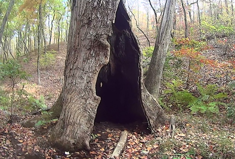
Who says you have to go north to experience mountain hiking – when there is the beautiful Pine Mountain Trail at FD Roosevelt State Park just a few miles south of the city. FD Roosevelt State Park is Georgia’s largest State Park with over 40 miles of trails to discover. For this event, we will be exploring a single loop combination of the Longleaf Loop and Big Poplar Loop totaling just under 16 miles and around 2000 feet of undulating elevation gain across a unique terrain of hardwoods, mountain laurels (yes there are mountain laurels in the Georgia Piedmont), pines (many with HUGE pinecones), along with several babbling brooks of crystal clear water. This is a great hike to get in a long and scenic D5 without the big elevation gain, but just enough ascent to get your heart and lungs pumping. For the most part plan to maintain a moderate pace, at brief times slowing to a leisurely pace for some of the scenic sections. Expect an average moving speed of about 2.5 mph – not including breaks. There are LOTs of trail crossings and intersections and it is very easy to get lost. So with that in mind, we will stick together as a group -- staying within visual and/or audible range throughout the hike. Details: Our carpool will leave promptly at 7:00 and we will begin the hike at about 8:15 am from the parking lot just below the visitor center/park office (2970 Georgia Highway 190 Pine Mountain, GA 31822). We will hike starting clockwise on the Longleaf loop initially headed westbound on the blue blazed Pine Mountain Trail (PMT). For the first half mile we will be hiking along a ridge parallel to highway 190 and continue past Buzzard’s Roost where we cross over the main highway and beginning a gentle downhill journey. At about 1.5 miles we take a short by-pass onto the very short CCC hatchery loop (1/4 mile long loop). We walk along an old abandoned dried up fish hatchery built by the Civilian Conservation Corps in the late 1930’s. After the quick journey through the old hatchery grounds, we make our way to the nearby red blazed Mountain Creek Nature Trail and begin a slight uphill journey. At mile 3.5 we will arrive at the RV campsite bath house to take a quick break to use the facilities and freshen up. We continue the loop on the white blazed Delano Interpretive Trail (don’t let the white blaze fool you, it isn’t the AT). Here you will see mountain laurels and we may hear a woodpecker tapping away and ... our first of a few small water features. Just after 4 miles we will turn right onto the Pool Trail taking us by the Liberty Bell swimming pool at just after mile 5.5 (sorry, pool’s closed for the winter). Here we begin our steepest climb (which lasts about ¾ of a mile). At around mile 6.5 we go east on the Pine Mountain Trail beginning the Big Poplar Loop portion of our hike. We continue the climb for another quarter mile to the top of Indian Mountain. Here we continue down and will take our lunch break around mile 8.5 just after Rattlesnake Bluff at a very scenic crystal clear spring. After lunch notice after about a mile on the right will be the Big Poplar tree (pictured) that was struck by lightning years ago (near PMT mile marker 10). We continue another mile and cross back over the main road at the Mollyhugger Hill Parking Lot and shortly after take a right turn on the Sawtooth Trail (so far we’ve hiked 11 miles). Keep a lookout on this section for the HUGE pinecones. After about 2.5 miles on the Sawtooth and crossing several horse trails, the trail dead ends back at the PMT. Turning left we continue westbound once again on the PMT (and back on the Longleaf loop) for the homestretch of about another 2.5 miles to finish our loop (with a few chances of long scenic views to our left). Arriving back at the parking lot we will celebrate with high fives, fist bumps, and selfies before our drive back to the carpool. Route Profile: https://www.plotaroute.com/routeprofile/328954 | |||||||
| |||||||
| How to Get There: | |||||||
| Event Directions: | Travel south of Atlanta from I-285 onto I-85 south toward Montgomery to Exit 21 for I-I85 toward Columbus/Fort Benning. You will only be on I-185 a few miles to Exit 42 and US 27 south (5.9 miles from the start of the off ramp off I-85 to the off ramp at Exit 42). | ||||||
| Carpool to Event Distance (round trip): | 134Mile(s) | ||||||
| Carpool Departure Time: | 7:00 am | ||||||
| Carpool Location: | Log in for location | ||||||
| Carpool Directions: | Log in for directions | ||||||
| Carpool Cost: | Estimated cost per vehicle for this event is $53.60 using a reimbursement rate guideline of $0.400 per mile. The total amount should be divided by the number of people in the vehicle, including the driver. This is a guideline, not a rule, for drivers but the cost should not be higher unless there are extenuating circumstances. | ||||||
| Notes: | |||||||
|
If you are not an experienced hiker, or do not have previous D4 or D5 experience, this hike may be too strenuous for you. Keep in mind that although this hike doesn’t have the elevation gain of a typical D5, it is a long hike with lots of ups-and-downs and we have to maintain a moderate pace to finish before nightfall. Hikers who do not have recent D4 or D5 experience will be contacted to determine if this hike is suitable for you. This is for the safety of the individual hiker and to ensure the entire group can maintain an appropriate pace to finish the 16 miles on schedule. This is a State Park. If you don’t have a park pass, you will need to purchase one at the park office. * We encourage all members to follow our Etiquette Guidelines while participating in AOC events. | |||||||
Cancellation/Partial Attendance: Please review the AOC cancellation policy. | |||||||
 Calendar of Events
 Event Places