 Print-Friendly Version Print-Friendly Version
|
|
AT Woody Gap to Jarrard Gap and Back | |||||||
| The Basics: | |||||||
| Event Type: | Hike | ||||||
| Event Location: | Near Suches, Georgia | ||||||
| Date(s) & Time: | Sat, Apr 22 2017 7:30 am >> Sat, Apr 22 2017 5:00 pm (Carpool Departure: 7:30 am *log in for location*) | ||||||
| Registration Opens: | Tue, Apr 11 2017 8:30 pm | ||||||
| Registration Cut Off: | Fri, Apr 21 2017 8:30 am | ||||||
| Event Duration: | 9 Hours 30 Minutes | ||||||
| Difficulty Rating: | D4: Moderate to Difficult | ||||||
| Distance: | 11.6 Miles | ||||||
| Pace: | Moderate | ||||||
| Trip Leader(s): | Lisa Jeff  Email Trip Leader(s) Email Trip Leader(s)
You must be logged in to get the Trip Leader contact information. | ||||||
| Member Cost: | None | ||||||
| Participant Info: | |||||||
| Who's Invited: | Members Only, 21 And Older Only | ||||||
| Maximum Group Size: | 12 | ||||||
| Minimum Group Size: | 4 | ||||||
| Number Registered So Far: | 13 / 0 (To see who's signed up, log in to the Member Area) | ||||||
| Are Dogs Permitted: | No | ||||||
| Itinerary: | |||||||
Please join us on Earth Day for a get-back-to-nature hike on one of the most scenic sections of the Applalachian Trail, a moderately challenging 11.6 mile trek from Woody Gap to Jarrard Gap.
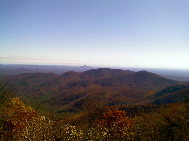
Our adventure begins at the easily accessible Woody Gap parking lot off GA 60 north of Dahlonega. We'll head north on the Appalachian Trail, beginning with some gentle climbs and descents through a hardwood forest. At a little over a mile, we'll climb a switchback to the top of Big Cedar Mountain, where we will enjoy sweeping vistas from an outcrop known as Preacher's Rock. From here, we'll pass multiple campsites and soon reach Miller Gap, where the Dockery Lake Trail joins the AT and where we should have an excellent view of the Blood Mountain Wilderness area. After the hike, the trip leaders plan to stop at Yahoola Creek Grill in Dahlonega, which features Southern-inspired cuisine and wines -- much of it from produce and vines cultivated in the North Georgia soil. The restaurant is on GA 60 along our return route, about a mile south of downtown Dahlonenga. Please add a note when you register whether you will be joining us for lunch. The estimated event duration encompasses carpooling and the restaurant stop. Parking at the trailhead does get crowded at times, so please consider carpooling if you're able. The carpools will depart the Mansell Road Park and Ride at 7:30am (please arrive 10-15 minutes early to allow time for introductions and carpool assignments), with an expected trailhead arrival of 8:45am. We will begin the hike no later than 9:00am. There are restrooms at the trailhead, so we do not plan to stop on the drive from the carpool meetup to the trailhead.
| |||||||
| |||||||
| How to Get There: | |||||||
| Event Directions: | To Trailhead from Mansell Road Park and Ride > Exit right from the parking lot onto Mansell Road, quickly getting into one of the two left-hand turn lanes. > Turn left at the first light onto the ramp to GA 400 / US 19. > Continue on GA 400 / US 19 for approximately 53 miles to the intersection with GA 60. > Make a left on GA 60 (it's co-signed as US 19 for a while) and continue for a little over five miles to the trailhead. Watch the signage; GA 60 will make a right-hand turn at the bottom of the hill just before downtown Dahlonega. Also, when you get to the rock pile northwest of Dahlonega, continue straight on GA 60. The trailhead and a parking lot will be on the right; an additional parking lot is across the road. Parking is free. If you reach the town of Suches, you've gone too far. The published GPS coordinates for the trailhead are 34.677883, -83.999550.
To Restaurant from Trailhead > Head east on GA 60 back toward Dahlonega. > The restaurant is on GA 60 about a mile south of Dahlonega, on the right. Yahoola Creek Grill, 1810 S. Chestatee St, Dahlonega, GA 305333. 706-482-2200.
Approxmiate round-trip distance per Google Maps (with or without the lunch stop) is 114 miles.
| ||||||
| Carpool to Event Distance (round trip): | 114Mile(s) | ||||||
| Carpool Departure Time: | 7:30 am | ||||||
| Carpool Location: | Log in for location | ||||||
| Carpool Directions: | Log in for directions | ||||||
| Carpool Cost: | Estimated cost per vehicle for this event is $45.60 using a reimbursement rate guideline of $0.400 per mile. The total amount should be divided by the number of people in the vehicle, including the driver. This is a guideline, not a rule, for drivers but the cost should not be higher unless there are extenuating circumstances. | ||||||
| Notes: | |||||||
|
* We encourage all members to follow our Etiquette Guidelines while participating in AOC events. | |||||||
Cancellation/Partial Attendance: Please review the AOC cancellation policy. | |||||||
 Calendar of Events
 Event Places