 Print-Friendly Version Print-Friendly Version
|
|
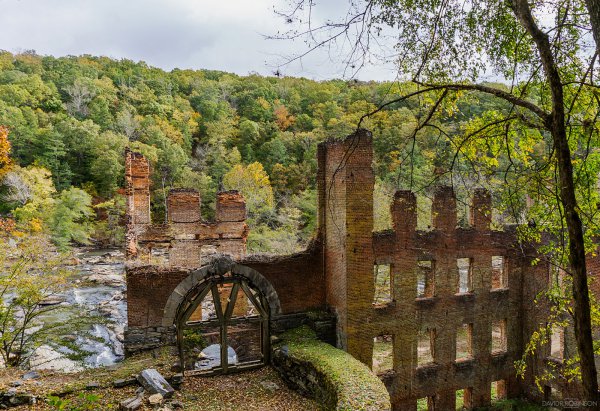
Exploring the Creekside & Lakeshore Trails and Civil War Ruins of Sweetwater Creek State Park | |||||||
| The Basics: | |||||||
| Event Type: | Hike | ||||||
| Event Location: |
~15 miles W of Atlanta, near I-20 Exit #41


| ||||||
| Date(s) & Time: | Wed, Mar 29 2017 12:00 pm >> Wed, Mar 29 2017 2:30 pm | ||||||
| Registration Opens: | Mon, Mar 27 2017 12:00 pm | ||||||
| Registration Cut Off: | Wed, Mar 29 2017 10:00 am | ||||||
| Event Duration: | 2 Hours 30 Minutes | ||||||
| Difficulty Rating: | D2: Easy to Moderate | ||||||
| Distance: | 5 Miles | ||||||
| Pace: | Moderate | ||||||
| Trip Leader(s): | Charlie Cottingham Email Trip Leader(s) Email Trip Leader(s)
You must be logged in to get the Trip Leader contact information. | ||||||
| Member Cost: | None | ||||||
| Participant Info: | |||||||
| Who's Invited: | Members Only, 21 And Older Only | ||||||
| Maximum Group Size: | 12 | ||||||
| Minimum Group Size: | 2 | ||||||
| Number Registered So Far: | 8 / 0 (To see who's signed up, log in to the Member Area) | ||||||
| Are Dogs Permitted: | Yes | ||||||
| Itinerary: | |||||||
IN A NUTSHELL: The beautiful and historic 2500-acre Sweetwater Creek State Conservation Park is just a few minutes west of Atlanta via I-20, but is sadly under-appreciated by most Atlantans, I hope you can join us this Wednesday for an adventurous moderately paced 5-mile hike that will include much of the shoreline of the park's 20-acre lake (a.k.a. "Sparks Reservoir") as well as a couple of its most popular creekside trails. The weather forecast expects a gorgeous spring day - in the 70s at midday, with lots of sunshine. GENERAL HIKE PLAN: There are dozens of "hidden gems" in the park that are unknown to most visitors but appear on my own detailed GA Orienteering Club topographic maps. During our hike we'll take the time to locate many of these interesting mapped objects, as my O Club friends and I have enjoyed at numerous "O meets" there over the decades. Some of these "gems" are around the periphery of the lake and others can be found along Sweetwater Creek and its adjoining forested hillsides, etc. Along the way we can review the basics of how to use a topo map in conjunction with a simple magnetic compass to help us stay on course and safe in wilderness areas. Leashed well-behaved dogs are welcome provided that they're kept under their owners' control at all times. For more about Sweetwater Creek State Park click this link: http://www.gastateparks.org/SweetwaterCreek For more about the GA Orienteering Club click this link: http://gaorienteering.org/ | |||||||
| |||||||
| How to Get There: | |||||||
| Event Directions: | DIRECTIONS to our lakeside PARKING & PICNICKING SPOT at SWEETWATER CREEK STATE PARK: (This small lot is on Mt. Vernon Rd just north of the bridge over the Park's big lake) EASY STEP-by-STEP DIRECTIONS for DRIVERS coming from ATLANTA: | ||||||
| Notes: | |||||||
|
* We encourage all members to follow our Etiquette Guidelines while participating in AOC events. | |||||||
Cancellation/Partial Attendance: Please review the AOC cancellation policy. | |||||||
 Calendar of Events
 Event Places