 Print-Friendly Version Print-Friendly Version
|
Night hike at Mason Mill Park just after this evening’s AOC Social | |||||||
| The Basics: | |||||||
| Event Type: | Hike | ||||||
| Event Location: |
NE Atlanta near Clairmont Rd & I-85


| ||||||
| Date(s) & Time: | Sun, Jul 30 2017 8:15 pm >> Sun, Jul 30 2017 9:45 pm | ||||||
| Registration Opens: | Sun, Jul 30 2017 9:00 am | ||||||
| Registration Cut Off: | Sun, Jul 30 2017 8:00 pm | ||||||
| Event Duration: | 1 Hours 30 Minutes | ||||||
| Difficulty Rating: | D1: Easy | ||||||
| Distance: | 4 Miles | ||||||
| Pace: | Moderate | ||||||
| Trip Leader(s): | Charlie Cottingham Kym  Email Trip Leader(s) Email Trip Leader(s)
You must be logged in to get the Trip Leader contact information. | ||||||
| Member Cost: | None | ||||||
| Participant Info: | |||||||
| Who's Invited: | Members Only, 21 And Older Only | ||||||
| Maximum Group Size: | 15 | ||||||
| Minimum Group Size: | 2 | ||||||
| Number Registered So Far: | 3 / 0 (To see who's signed up, log in to the Member Area) | ||||||
| Are Dogs Permitted: | No | ||||||
| Itinerary: | |||||||
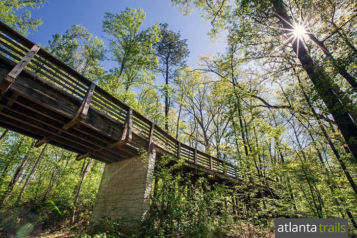
EVENT PLAN: Hope you can join us this evening to enjoy the suddenly cooler midsummer weather with a night hike at Mason Mill Park, which is just a 10 minute drive from the AOC Social at 57th Fighter Group restaurant (southward about 5 miles via Clairmont Rd - see detailed Directions below). We'll gather at 8:15 PM just inside the Mason Mill Park entrance, in the free parking lot (by the stone restroom building and kids' playground). Along the way we'll explore portions of several newly built "Silver-Comet-like" trails and raised boardwalks. Atlanta's PATH Foundation began construction on them last year to connect Mason Mill with Emory University's trails and other nearby parks and greenspaces. From the scale of the project these new "spur and connecting trails" are obviously costing millions of dollars in public funds to build. We'll pause occasionally to enjoy the native wild flora & fauna and other interesting scenery. Our total distance will be about 4 miles with just one or two steep spots. We'll target being back at the cars by 9:45 PM. If you need to "split" early from the group that's OK, but be sure to let me know if and when you do so. It should be easy to direct you back to the parking lot. ABOUT the PARKS, TRAILS and HIKING OPTIONS: The three pretty DeKalb County parks mentioned above are located just east of Clairmont Road near Emory University and the VA Hospital. They conveniently connect with one another via a network of heavily forested trails and raised boardwalks. The South Peachtree Creek Trail is the main artery through this corridor, and like the Silver Comet Trail was built to the high standards of Atlanta's "PATH Foundation." Branching from it are several miles of ruggedly scenic narrower trails, many which wind around loops of the creeks. An impressive section of the main PATH Trail traverses the railroad track via a 3-story-wooden deck and walkway. Here hikers and bikers are treated to aerial views of the restored ruins of the historic early-20th-Century Decatur Waterworks. The highest portion of the deck has proven to be a good dark spot for urban "skygazing" - i.e, viewing the stars & planets, sunsets, moonrises, eclipses, meteor showers, comets, etc. A new feature of the Waterworks area is a set of large flat stepping stones across the adjoining creek, allowing hikers to access the white-blazed Ira Melton Park trail. Although it won't be included this time, another option (that we sometimes include in hikes of 3 hours or more) is to walk beyond Medlock Park a few blocks through the neighborhood to lovely Clyde Shepherd Nature Preserve and do at least a short "wetlands" loop there before heading back (via Medlock Park) to our Mason Mill Park meetup spot. FOR a COLOR MAP of the SOUTH PEACHTREE CREEK "PATH" TRAIL and how it interconnects Mason Mill & Medlock Park and other DeKalb County-owned green space, click this link: http://pathfoundation.org/wp-content/uploads/2011/11/south-peachtree-creek-trail.pdf | |||||||
| |||||||
| How to Get There: | |||||||
| Event Directions: | FROM the I-85 CLAIRMONT ROAD EXIT in NE METRO ATLANTA to our MASON MILL PARK Meetup Spot: (For a zoomable color MAP and satellite view of this spot and its vicinity click on the square blue & green "Event Location" near the top of this article.) 1. From the I-85 "Clairmont Road" Exit (Exit #91) in NE Atlanta take Clairmont Rd southward (toward Decatur) about 2.3 miles to the traffic light at McConnell Drive. (This is the next light south of the big Clairmont/ North Druid Hills intersection. If you reach the huge VA Hospital you've gone a couple of blocks too far!) LAT/LON COORDINATES of the Mason Mill Park spot where we'll meet: (You GPS or Google.com/maps users may wish to augment my above verbal directions by entering these map coordinates as your destination address.) | ||||||
| Notes: | |||||||
|
* We encourage all members to follow our Etiquette Guidelines while participating in AOC events. | |||||||
| Cost Includes: | Free Event with Free Parking! | ||||||
Cancellation/Partial Attendance: Please review the AOC cancellation policy. | |||||||
 Calendar of Events
 Event Places