 Print-Friendly Version Print-Friendly Version
|
|
Laurel Ridge Trail - Lake Lanier | |||||||
| The Basics: | |||||||
| Event Type: | Hike | ||||||
| Event Location: |
Buford, GA


| ||||||
| Date(s) & Time: | Sun, Nov 26 2017 8:30 am >> Sun, Nov 26 2017 10:15 am | ||||||
| Registration Opens: | Tue, Nov 21 2017 10:00 pm | ||||||
| Registration Cut Off: | Sat, Nov 25 2017 11:00 pm | ||||||
| Event Duration: | 1 Hours 45 Minutes | ||||||
| Difficulty Rating: | D2: Easy to Moderate | ||||||
| Distance: | 4.1 Miles | ||||||
| Pace: | Moderate | ||||||
| Trip Leader(s): | Lauren Email Trip Leader(s) Email Trip Leader(s)
You must be logged in to get the Trip Leader contact information. | ||||||
| Member Cost: | None | ||||||
| Participant Info: | |||||||
| Who's Invited: | Members Only, 21 And Older Only | ||||||
| Maximum Group Size: | 10 | ||||||
| Minimum Group Size: | 4 | ||||||
| Number Registered So Far: | 3 / 0 (To see who's signed up, log in to the Member Area) | ||||||
| Are Dogs Permitted: | No | ||||||
| Itinerary: | |||||||
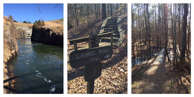
Laurel Ridge Trail is a loop that has good mix of small rolling hills and very pretty scenery. About half of the hike overlooks Lake Lanier and the other half winds through the woods. There is an occasional parking lot crossing (weird, I know, but overall it's a pretty hike). Total hiking distance is just over four miles. We will stop by the backside of Buford Dam. There are regular water releases from Lake Lanier and this water will flow from the lake southward through Atlanta (and all of our CRNRA parks). The water coming out of the dam is what makes up the Chattahoochee River as it flows through Atlanta. The hike is just over 4 miles with about 700 feet of elevation gain. We will make a few quick stops to look at scenery but not many stops along the way. Pace will be moderate, not too fast but not too slow. We will depart from the Lower Overlook Park which is convenient from both GA400 and I-85/I-985. Parking is free and there is a restroom (but I can't guarantee it will be open). We will begin the hike on time. Address is: Lower Overlook Park 1060 Buford Dam Road Buford, GA 30515 OR open maps.google.com and paste the bold text in to your search bar Latitude, Longitude: 34.15850503465993, -84.0699634969223
Sorry, they don't allow dogs on this trail. Trail info: http://www.hikethesouth.com/Hike.aspx?id=24 | |||||||
| |||||||
| How to Get There: | |||||||
| Event Directions: | Address for Lower Overlook Park: 1060 Buford Dam Road
Latitude, Longitude: 34.15850503465993, -84.0699634969223 | ||||||
| Notes: | |||||||
|
* We encourage all members to follow our Etiquette Guidelines while participating in AOC events. | |||||||
Cancellation/Partial Attendance: Please review the AOC cancellation policy. | |||||||
 Calendar of Events
 Event Places