 Print-Friendly Version Print-Friendly Version
|
Siler Bald & Wayah Bald on the AT | |||||||
| The Basics: | |||||||
| Event Type: | Hike | ||||||
| Event Location: |
west of Franklin, NC


| ||||||
| Date(s) & Time: | Sat, Jan 27 2018 10:00 am >> Sat, Jan 27 2018 7:00 pm (Carpool Departure: 8:00 am *log in for location*) | ||||||
| Registration Opens: | Thu, Jan 18 2018 7:34 am | ||||||
| Registration Cut Off: | Fri, Jan 26 2018 5:00 pm | ||||||
| Event Duration: | 9 Hours | ||||||
| Difficulty Rating: | D5: Difficult | ||||||
| Distance: | 12 Miles | ||||||
| Pace: | Moderate | ||||||
| Trip Leader(s): | Mike S Dorothea  Email Trip Leader(s) Email Trip Leader(s)
You must be logged in to get the Trip Leader contact information. | ||||||
| Member Cost: | None | ||||||
| Participant Info: | |||||||
| Who's Invited: | Members Only, 21 And Older Only | ||||||
| Maximum Group Size: | 12 | ||||||
| Minimum Group Size: | 2 | ||||||
| Number Registered So Far: | 10 / 0 (To see who's signed up, log in to the Member Area) | ||||||
| Are Dogs Permitted: | No | ||||||
| Itinerary: | |||||||
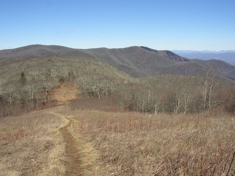
Here we have two magnificent views on a figure-8 hike. The center of the figure 8 is the parking lot at Wayah Gap (~4200 ft). To make the first loop we ascend Siler Bald (5216 ft), where we will enjoy a 360-degree view on a wide-open grassy crown, after which we return to Wayah Gap (4 miles, 2 hours). For the second loop we cross the road and ascend Winespring Mountain and continue along the ridge to Wayah Bald (5350 ft), where we enjoy another almost 360-degree view from the recently restored fire tower, before returning to Wayah Gap (8 miles, 4 hours). Total elevation gain about 3000 ft. If the sun is out and there is no wind we will stop for 30 minutes (11:00-11:30) on Siler Bald to take in the spectacular view shown in the photo and to eat an early lunch. If the weather is such that we need to keep moving, we will make a short lunch stop in a protected area near Winespring Creek (about 1:00). Otherwise we will keep moving until we get to the top of Wayah (2:30), where we can eat again. With that in mind, you might want to pack a lunch that can be eaten in stages or at least one that does not require the full linen-and-silver treatment. We will have dinner in Clayton after the hike. If you do not wish or cannot stay for dinner, you should carpool with equally minded hikers or drive your own car as far as Clayton, where you can join the second carpool. Mike will coordinate the carpool at the Indian Trail park-and-ride. Anyone wishing to "meet at event," will join the group at the Clayton Ingles (south-west corner of parking lot) at 9:15. A caveat: if there is any chance of encountering icy road on the way up to Wayah Gap, we will relocate the hike to Tray Mountain from Andrews Cove with a later start. | |||||||
| |||||||
| How to Get There: | |||||||
| Event Directions: | From the Indian Trail park & ride, take I-85 North. After 11 miles bear left to take I-985 North. This road will change to GA 365, US 441, and US 23. Stay on it for 75 miles, then stop at the Clayton Ingles for a pit-stop and to pick up hikers meeting at event. Once back on the 441, it is 21 miles to Franklin. Make a left onto US 64 West. Go 3.7 miles on US 64 and make a right onto Old Murphy Road, then an immediate left onto Wayah Rd, SR 1310, which is all paved (Look for a sign for Wayah Bald on US 64). From there it is 8.9 miles to the Appalachian Trail. After you pass the hikers-crossing sign at the top of Wayah Gap, turn left into the parking lot of the Wayah Crest campground. Careful of the deep ruts in the gravel road. | ||||||
| Carpool to Event Distance (round trip): | 242Mile(s) | ||||||
| Carpool Departure Time: | 8:00 am | ||||||
| Carpool Location: | Log in for location | ||||||
| Carpool Directions: | Log in for directions | ||||||
| Carpool Cost: | Estimated cost per vehicle for this event is $96.80 using a reimbursement rate guideline of $0.400 per mile. The total amount should be divided by the number of people in the vehicle, including the driver. This is a guideline, not a rule, for drivers but the cost should not be higher unless there are extenuating circumstances. | ||||||
| Notes: | |||||||
|
We will be contacting anyone who has not recently completed a D5 hike to ascertain whether this is a good hike for you. * We encourage all members to follow our Etiquette Guidelines while participating in AOC events. | |||||||
Cancellation/Partial Attendance: Please review the AOC cancellation policy. | |||||||
 Calendar of Events
 Event Places