 Print-Friendly Version Print-Friendly Version
|
|
Linville Gorge Sight Seeing Edition | |||||||
| The Basics: | |||||||
| Event Type: | Backpacking | ||||||
| Event Location: |
Morganton NC


| ||||||
| Date(s) & Time: | Sat, Mar 3 2018 5:00 am >> Sun, Mar 4 2018 10:00 pm (Carpool Departure: 5:00 am *log in for location*) | ||||||
| Registration Opens: | Mon, Feb 19 2018 9:30 pm | ||||||
| Registration Cut Off: | Fri, Mar 2 2018 8:30 pm | ||||||
| Event Duration: | 1 Days 17 Hours | ||||||
| Difficulty Rating: | D4: Moderate to Difficult | ||||||
| Distance: | 16 Miles | ||||||
| Pace: | Moderate | ||||||
| Trip Leader(s): | Eric P Email Trip Leader(s) Email Trip Leader(s)
You must be logged in to get the Trip Leader contact information. | ||||||
| Member Cost: | None | ||||||
| Participant Info: | |||||||
| Who's Invited: | Members Only, 21 And Older Only | ||||||
| Maximum Group Size: | 5 | ||||||
| Minimum Group Size: | 2 | ||||||
| Number Registered So Far: | 4 / 0 (To see who's signed up, log in to the Member Area) | ||||||
| Are Dogs Permitted: | No | ||||||
| Itinerary: | |||||||
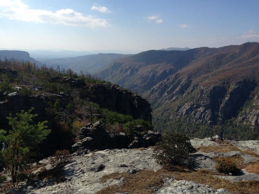
It's time to head back to my favorite spot in the Southeast. However I have been sick a lot lately and my cardio is suffering so this will be an easier trip with less mileage and very little of it with heavy packs. We will take many of the unofficial trails that can be overgrown, take you very close to cliff edges, require scrambling, and fording of the river. If that doesn't sound like a good time to you this is likely not a trip you will enjoy. Here is a rough map of where the trip may go, please note that things can change and that this is just me crudely marking the map as opposed to a true gps track: https://caltopo.com/m/7QT1 The weather in early march can be anything from very cold to warm and comfortable. Please check the forecast and bring appropriate clothing and sleeping bags. The plan is to hike roughly 1.5 miles from the Spence Ridge Trailhead up a significant climb to Little Table Rock where we will set up camp and leave our heavy gear behind. From there we will spend the rest of the day exploring(4.5-6miles) between Table Rock and the Chimneys. Water sources can be scarce and you should plan on starting with all of the water you need for the first day. Supposedly there is a small water source near the campsite but I have never used it to know how reliable it is. Please note that I prefer not having fires at night because of the impact they have on the land. This area has had several large fires in recent years. There are extremely nice views near the campsite to enjoy as the day comes to a close. The second day will start early to give us plenty of time to hike and get home at a decent hour with a 1.5 mile walk back down to the car where we will drop off packs and then start a day hike(~8.5 miles) that will involve scrambling up hawksbill on the ledge trail, checking out Sitting Bear and Celestial Point, then potentially fording the river twice at Devils Hole and Spence Bridge depending on the water levels. Water levels can be seen here https://waterdata.usgs.gov/nwis/uv?02138500 . These crossings can be waist deep, please be prepared. If the water is too high we will adjust the plans for this day. The best map of the area can be found here: http://www.lgmaps.org/?page_id=15 . It is much more detailed than any print map you can purchase. Additionally it is available as a free map for the free phone gps app called Avenza. I plan on keeping this group small and driving the car pool with the below fees depending on group size: 2 people: $45 each 3 people: $30 each 4 people: $25 each I will allow up to 2 additional people to drive themselves with an absolute maximum group size of 6 people. Any larger than that and it starts getting tough to keep everyone camped close to each other. It is quite a long drive(4.5 hours) each way which is why the carpool leaves so early on Saturday. It will not offend me if you want to take a nap on the drive up to the gorge. Additionally I posted it ending at 10pm in case we end up taking most of the day hiking although it is unlikely we will get back that late, but do plan for this taking up your entire weekend. | |||||||
| |||||||
| How to Get There: | |||||||
| Event Directions: | We will begin at the Spence Ridge Trailhead https://goo.gl/maps/cN6N1eCQoAu The last few miles are on a dirt road but I have taken it in a Honda Civic multiple times with no problem. | ||||||
| Carpool to Event Distance (round trip): | 494Mile(s) | ||||||
| Carpool Departure Time: | 5:00 am | ||||||
| Carpool Location: | Log in for location | ||||||
| Carpool Directions: | Log in for directions | ||||||
| Carpool Cost: | Estimated cost per vehicle for this event is $197.60 using a reimbursement rate guideline of $0.400 per mile. The total amount should be divided by the number of people in the vehicle, including the driver. This is a guideline, not a rule, for drivers but the cost should not be higher unless there are extenuating circumstances. | ||||||
| Notes: | |||||||
|
* We encourage all members to follow our Etiquette Guidelines while participating in AOC events. | |||||||
Cancellation/Partial Attendance: Please review the AOC cancellation policy. | |||||||
 Calendar of Events
 Event Places