 Print-Friendly Version Print-Friendly Version
|
|
Springer Mountain - A New Approach | |||||||
| The Basics: | |||||||
| Event Type: | Hike | ||||||
| Event Location: |
Near Nimblewill GA


| ||||||
| Date(s) & Time: | Sat, Mar 3 2018 10:45 am >> Sat, Mar 3 2018 3:45 pm (Carpool Departure: 9:00 am *log in for location*) | ||||||
| Registration Opens: | Wed, Feb 28 2018 10:00 pm | ||||||
| Registration Cut Off: | Fri, Mar 2 2018 5:00 pm | ||||||
| Event Duration: | 5 Hours | ||||||
| Difficulty Rating: | D4: Moderate to Difficult | ||||||
| Distance: | 9 Miles | ||||||
| Pace: | Moderate | ||||||
| Trip Leader(s): | John Weatherman Email Trip Leader(s) Email Trip Leader(s)
You must be logged in to get the Trip Leader contact information. | ||||||
| Member Cost: | None | ||||||
| Participant Info: | |||||||
| Who's Invited: | Members Only, 21 And Older Only | ||||||
| Maximum Group Size: | 12 | ||||||
| Minimum Group Size: | 4 | ||||||
| Number Registered So Far: | 8 / 0 (To see who's signed up, log in to the Member Area) | ||||||
| Are Dogs Permitted: | Yes | ||||||
| Itinerary: | |||||||
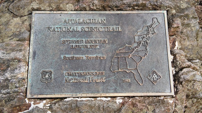
Springer Mountain is an iconic location due to its being the Southern Terminus of the Appalachian Trail. It is at 3782 feet in elevation and has at least one clear long distance view from the top. This hike involves a new way to get there; at least it was new to me. We will be starting from the bottom at about 1750 feet of elevation, and we will be using the Bull Mountian Trail System to get most of the way. Then it is a mile straight up a ridge to the top. The Bull Mountain Trail System is primarily used by mountain bikers, but also by horse riders and a few hikers. From where we park, we will go up the Saddle Back Trail for about three miles with a gain of about 1000 feet to a cairn at the highest point. From there we leave the marked trail and we will follow a faint, intermittent trail which will lead us up a ridge directly to the summit. On this mile of part bushwack, part trail we will gain our remaining 1000 feet of elevation. We do not deviate from our route if we temorarily lose our trail since it is entirely on the ridge and we can pick it up again in a few yards. We will have good winter views as we get higher and higher. Once we get to the top, there is usually a crowd there, and we can hang out and eat lunch. Then we go back down our intermittent trail to the cairn. From there we will turn right to meet up with the Lance Creek Trail which will take us back down to our cars in about three miles. This trail is more scenic than the one we went up with a nice creek with sluices and falls along it. There are fewer bikers on this downhill trail than on our uphill trail. | |||||||
| |||||||
| How to Get There: | |||||||
| Event Directions: | Out of the park and ride go north on GA 400. After 30 miles take a left on GA Hwy 53 W. In 6.5 miles you will be in Dawsonville. There turn right on Shoal Creek Rd/State Spur 136. In 2.5 miles take a slight left onto GA-136 W. In 3.2 miles take a right onto State Route 342. In 2.4 miles take a right on Max Wehunt. In 1.2 miles take a right onto GA-52 E. In 1.8 miles take a left onto Nimblewill Church Rd. In 1.3 miles take a left onto Forest Service 28-1. In 2.0 miles take a left at the fork. In about 300 ft the road turns right and becomes Winding Stair Gap Rd aka FS 77. In 1.3 miles turn left onto Jones Creek Rd aka FS 77A. In 1.5 miles take a left to stay on Jones Creek Rd/FS 77A. In 0.2 miles reach the closed gate and park on the right. | ||||||
| Carpool to Event Distance (round trip): | 106Mile(s) | ||||||
| Carpool Departure Time: | 9:00 am | ||||||
| Carpool Location: | Log in for location | ||||||
| Carpool Directions: | Log in for directions | ||||||
| Carpool Cost: | Estimated cost per vehicle for this event is $42.40 using a reimbursement rate guideline of $0.400 per mile. The total amount should be divided by the number of people in the vehicle, including the driver. This is a guideline, not a rule, for drivers but the cost should not be higher unless there are extenuating circumstances. | ||||||
| Notes: | |||||||
|
* We encourage all members to follow our Etiquette Guidelines while participating in AOC events. | |||||||
Cancellation/Partial Attendance: Please review the AOC cancellation policy. | |||||||
 Calendar of Events
 Event Places