 Print-Friendly Version Print-Friendly Version
|
|
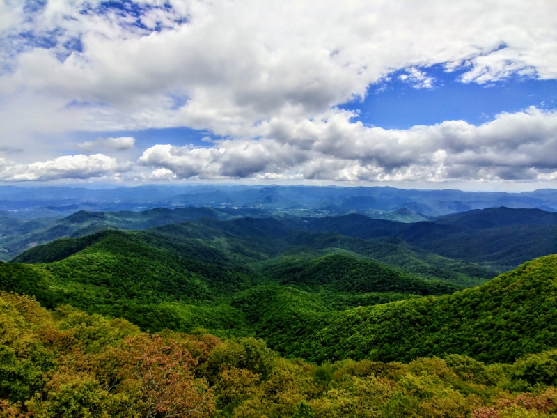
Albert Mountain Lookout Tower from Rock Gap | |||||||
| The Basics: | |||||||
| Event Type: | Hike | ||||||
| Event Location: |
Franklin, NC


| ||||||
| Date(s) & Time: | Sat, Apr 14 2018 6:30 am >> Sat, Apr 14 2018 7:00 pm (Carpool Departure: 6:30 am *log in for location*) | ||||||
| Registration Opens: | Thu, Mar 29 2018 8:00 pm | ||||||
| Registration Cut Off: | Fri, Apr 13 2018 10:00 am | ||||||
| Event Duration: | 12 Hours 30 Minutes | ||||||
| Difficulty Rating: | D4: Moderate to Difficult | ||||||
| Distance: | 12 Miles | ||||||
| Pace: | Moderate | ||||||
| Trip Leader(s): | Chuck R Email Trip Leader(s) Email Trip Leader(s)
You must be logged in to get the Trip Leader contact information. | ||||||
| Member Cost: | None | ||||||
| Participant Info: | |||||||
| Who's Invited: | Members Only, 21 And Older Only | ||||||
| Maximum Group Size: | 10 | ||||||
| Minimum Group Size: | 3 | ||||||
| Number Registered So Far: | 8 / 0 (To see who's signed up, log in to the Member Area) | ||||||
| Are Dogs Permitted: | Yes | ||||||
| Itinerary: | |||||||
| Albert mountain 5,210 ft offers a 360 view. Just sits north of the southern Nantahala Wilderness with eastern slopes, plunging into a gorge. On a clear day you can see Whiteside Mountain, southeast of the Highlands. Our hike will began at Rock Gap on the Appalachian Trail just before entering The Standing Indian Campgrounds. We will head south for 6 miles to Albert Mountain and take lunch . After lunch and the gorgeous views we will retrace our steps back to our cars. Approximately Elevation gain is around 2050 ft. | |||||||
| |||||||
| How to Get There: | |||||||
| Event Directions: | From Indian Trail Park and Ride, go north on I-85 Merge in to left lanes and continue on I-985 I-985 will turn into US-23 N/US-441 N/GA-15; remain on this road to Franklin, NC As you come towards Franklin, NC, go West on US 64 From Franklin, take US 64W for about 12 miles, turn left on S.R.1448 (West Old Murphy Road, old US 64). There will be a brown sign before you get to the intersection that indicates the left turn to Wallace Gap/Standing Indian Campground. Continue on S.R. 1448 to Wallace Gap (about 1.9 miles) and turn right, following the sign to Standing Indian Campground. You will see a paved parking area on the left. This is Rock Gap. We will meet in the parking area at rock Gap. (If you get the the Standing Indian Campground or Backcountry Information Center, you have gone too far). | ||||||
| Carpool to Event Distance (round trip): | 246Mile(s) | ||||||
| Carpool Departure Time: | 6:30 am | ||||||
| Carpool Location: | Log in for location | ||||||
| Carpool Directions: | Log in for directions | ||||||
| Carpool Cost: | Estimated cost per vehicle for this event is $98.40 using a reimbursement rate guideline of $0.400 per mile. The total amount should be divided by the number of people in the vehicle, including the driver. This is a guideline, not a rule, for drivers but the cost should not be higher unless there are extenuating circumstances. | ||||||
| Notes: | |||||||
|
Will hike rain if conditions are favorable. Plenty of drivers! * We encourage all members to follow our Etiquette Guidelines while participating in AOC events. | |||||||
Cancellation/Partial Attendance: Please review the AOC cancellation policy. | |||||||
 Calendar of Events
 Event Places