 Print-Friendly Version Print-Friendly Version
|
|
Interstate North Trails of CRNRA Summer Style Jaunt | |||||||
| The Basics: | |||||||
| Event Type: | Hike | ||||||
| Event Location: |
Interstate North / Cochran Shoales Trails of CRNRA


| ||||||
| Date(s) & Time: | Wed, Jul 11 2018 9:30 am >> Wed, Jul 11 2018 11:00 am | ||||||
| Registration Opens: | Sat, Jul 7 2018 3:00 pm | ||||||
| Registration Cut Off: | Wed, Jul 11 2018 8:00 am | ||||||
| Event Duration: | 1 Hours 30 Minutes | ||||||
| Difficulty Rating: | D2: Easy to Moderate | ||||||
| Distance: | 4 Miles | ||||||
| Pace: | Moderate | ||||||
| Trip Leader(s): | Holt Ward Email Trip Leader(s) Email Trip Leader(s)
You must be logged in to get the Trip Leader contact information. | ||||||
| Member Cost: | None | ||||||
| Participant Info: | |||||||
| Who's Invited: | Members Only, 21 And Older Only | ||||||
| Maximum Group Size: | 14 | ||||||
| Minimum Group Size: | 2 | ||||||
| Number Registered So Far: | 10 / 0 (To see who's signed up, log in to the Member Area) | ||||||
| Are Dogs Permitted: | No | ||||||
| Itinerary: | |||||||
Let’s hike the Interstate North trails of CRNRA and do it as a summer style jaunt. What do I mean by that? This hike is a little shorter and less strenuous than our typical Interstate North hike which fits the warm and humid summer temps. We will start at 9:30 am, for this one and finish at 11 am, before it heats up too much but will still get in about 4 miles. These are some of the lesser utilized trails of the CRNRA. The beginning and ending of this hike are along the river and generally flat but the middle does offer several hills, some of which are steep (but short). We will meet at the parking lot located at 1956 Eugene Gunby Rd, Marietta, GA, 30067. Coordinates for the trailhead 33.902094, -84.444038 The trailhead is located off Interstate North Parkway, approximately 0.3 miles from its intersection with Powers Ferry Road (right before you cross the Chattahoochee River). This is a CRNRA unit so use your annual parking pass or pay $5 for parking. There are bathroom facilities at this location.
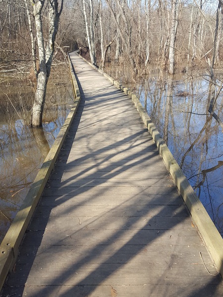
Itinerary Departing the parking lot, we will start with a 0.6 mile walk along the multi use trail along the Chattahoochee River as a warm up. Turning left, we will cross the Swamp on boardwalks and then begin our climbs. Along the way we will climb and descend several times as we make our way across a number of ridges which run down towards the river. The climbs are enough to get our hearts pumping but nothing terribly difficult.
Using an interesting group of connector trails which may be new to many on the hike, we will connect with the Cochran Shoals section of the CRNRA . After rock hopping across Terrell Branch Creek we will hike along its edge downstream. We will intersect the Multi use trail again and follow it back to our cars. The hike will cover about 4 miles in about 1.5 hours. | |||||||
| |||||||
| How to Get There: | |||||||
| Event Directions: | Coordinates for the trailhead 33.902094, -84.444038 Street Address is 1956 Eugene Gunby Rd, Marietta, GA, 30067 Eugene Gunby Road is right off Interstate North Parkway where it crosses the Chattahoochee River. Its on the Cobb County side of the river between the river and Powers Ferry Road. If you are headed away from the river towards Cobb County, its the first right after you cross the river. If you are on Interstate North Parkway headed towards Sandy Springs, its the last left before you reach the river. | ||||||
| Notes: | |||||||
|
* We encourage all members to follow our Etiquette Guidelines while participating in AOC events. | |||||||
Cancellation/Partial Attendance: Please review the AOC cancellation policy. | |||||||
 Calendar of Events
 Event Places