 Print-Friendly Version Print-Friendly Version
|
|
Shining Rock Wilderness Backpacking Friday-Sunday | |||||||
| The Basics: | |||||||
| Event Type: | Backpacking | ||||||
| Event Location: |
Pisgah National Forest & Shining Rock Wilderness


| ||||||
| Date(s) & Time: | Fri, Aug 3 2018 10:15 am >> Sun, Aug 5 2018 5:00 pm (Carpool Departure: 10:15 am *log in for location*) | ||||||
| Registration Opens: | Thu, Jul 19 2018 9:00 pm | ||||||
| Registration Cut Off: | Thu, Aug 2 2018 2:00 pm | ||||||
| Event Duration: | 2 Days 6 Hours 45 Minutes | ||||||
| Difficulty Rating: | D4: Moderate to Difficult | ||||||
| Distance: | 12 Miles | ||||||
| Pace: | Moderate | ||||||
| Trip Leader(s): | Kristi Grant Brown  Email Trip Leader(s) Email Trip Leader(s)
You must be logged in to get the Trip Leader contact information. | ||||||
| Member Cost: | None | ||||||
| Participant Info: | |||||||
| Who's Invited: | Members Only, 21 And Older Only | ||||||
| Maximum Group Size: | 10 | ||||||
| Minimum Group Size: | 4 | ||||||
| Number Registered So Far: | 8 / 0 (To see who's signed up, log in to the Member Area) | ||||||
| Are Dogs Permitted: | No | ||||||
| Itinerary: | |||||||
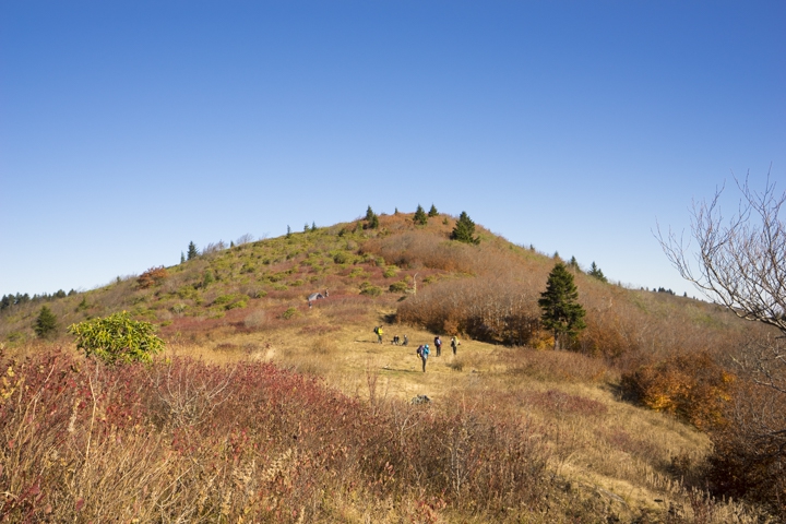
Join us for what should be a great summer weekend in the Shining Rock Wilderness. We will depart the carpool at 10:15 AM and drive approx 3 - 3 1/2 hrs to the small parking area at the trailhead to Flat Laurel Creek Trail on NC Hwy 215. We will hike in about 2 miles along the Flat Laurel Creek Trail and make camp somewhere close to to the creek, near the junction with the Sam Knob Trail. Ideally, we'll make camp along the bank, but we'll need to be flexible as it is first-come/first-serve. We can wade and relax in the water; there may be some nice jacuzzi's. After making camp and relaxing a bit, we can do a round-trip hike up to the top of Sam Knob (~3- 4m). We may decide to park at a different area and the hike into the camp area would be the same or less mileage. On Saturday, sometime after breakfast, we can "day-hike" to Black Balsam and Tennent Mountains via Sam Knob Trail and Art Loeb Trail, where we will see magnificent open views. We can make it a loop hike by returning on the Ivestor Gap Trail (or not). It is a climb to the first bald followed by typical ups and downs. The balds are at around the 6,000' height, so you may notice being affected a bit by the elevation. We'll have lunch and take in the views somewhere along these paths. It may be blueberry season at this elevation and you may want to bring a container to collect them. Bear-proof canisters are required in the Shining Rock Wilderness areas. Keep this in mind when signing up. It may be possible to share a few. (Campfires are difficult to build anyway, as there is very little wood in the area.) If you can't make it Friday, we can work it out to meet you on Saturday. More weather forecast details: https://www.m ountain- forecast.com/peaks/Shining- Rock/forecasts/1841 | |||||||
| |||||||
| How to Get There: | |||||||
| Event Directions: |
or | ||||||
| Carpool to Event Distance (round trip): | 350Mile(s) | ||||||
| Carpool Departure Time: | 10:15 am | ||||||
| Carpool Location: | Log in for location | ||||||
| Carpool Directions: | Log in for directions | ||||||
| Carpool Cost: | Estimated cost per vehicle for this event is $140.00 using a reimbursement rate guideline of $0.400 per mile. The total amount should be divided by the number of people in the vehicle, including the driver. This is a guideline, not a rule, for drivers but the cost should not be higher unless there are extenuating circumstances. | ||||||
| Notes: | |||||||
|
* We encourage all members to follow our Etiquette Guidelines while participating in AOC events. | |||||||
Cancellation/Partial Attendance: Please review the AOC cancellation policy. *Note: Please note high chance of rain/severe thunderstorms .. we may postpone it.
| |||||||
 Calendar of Events
 Event Places