 Print-Friendly Version Print-Friendly Version
|
|
Mason Mill Park Sunset Hike via new PATH Trails and old Creekside Favorites | |||||||
| The Basics: | |||||||
| Event Type: | Hike | ||||||
| Event Location: |
NE Atlanta near Clairmont Rd & I-85


| ||||||
| Date(s) & Time: | Thu, Aug 23 2018 6:30 pm >> Thu, Aug 23 2018 8:30 pm | ||||||
| Registration Opens: | Tue, Aug 21 2018 10:00 am | ||||||
| Registration Cut Off: | Thu, Aug 23 2018 4:30 pm | ||||||
| Event Duration: | 2 Hours | ||||||
| Difficulty Rating: | D2: Easy to Moderate | ||||||
| Distance: | 5 Miles | ||||||
| Pace: | Moderate | ||||||
| Trip Leader(s): | Charlie Cottingham Email Trip Leader(s) Email Trip Leader(s)
You must be logged in to get the Trip Leader contact information. | ||||||
| Member Cost: | None | ||||||
| Participant Info: | |||||||
| Who's Invited: | Members Only, 21 And Older Only | ||||||
| Maximum Group Size: | 15 | ||||||
| Minimum Group Size: | 2 | ||||||
| Number Registered So Far: | 17 / 0 (To see who's signed up, log in to the Member Area) | ||||||
| Are Dogs Permitted: | Yes | ||||||
| Itinerary: | |||||||
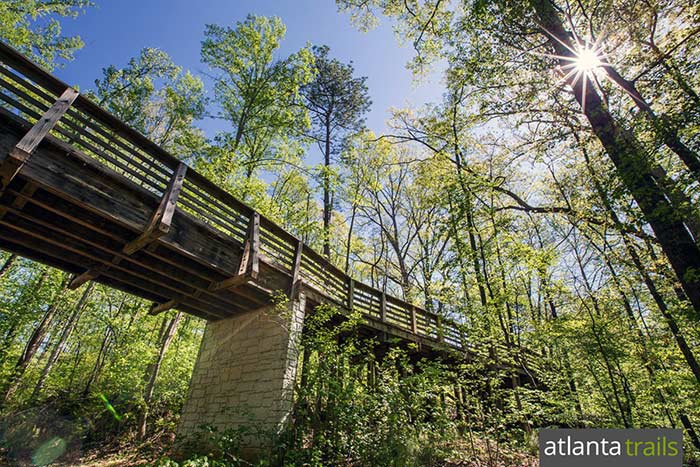
EVENT PLAN: Nice weather is expected this Thu evening with mostly sunny skies and comfortable temperatures & humidity. Hope you can join us for this adventurous and scenic but relatively easy hike. MORE ABOUT the PARKS, TRAILS and HIKING OPTIONS: The pretty DeKalb County parks & trails mentioned above now connect with one another - and also with Medlock Park and Ira Melton Park via a network of shady trails and raised boardwalks. The South Peachtree Creek Trail is the main artery through this "multi-park corridor," and like the Silver Comet Trail is built to the high standards of Atlanta's "PATH Foundation." Branching from it are several miles of ruggedly scenic narrow trails, many which adjoin the banks of "South Fork Peachtree Creek" and its sinuous tributaries. An impressive section of the main PATH Trail traverses the railroad track via a 3-story-wooden deck and walkway. Here hikers and bikers are treated to aerial views of the restored ruins of the historic early-20th-Century Decatur Waterworks. The highest portion of the deck has proven to be a good dark spot for urban "skygazing" - i.e, viewing the stars & planets, sunsets, moonrises, eclipses, meteor showers, etc. Also in the Waterworks area is a set of large flat stepping stones across the creek, which at normal water levels allow hikers to access Ira Melton Park's white-blazed loop trail. In 2017 a new ~1-mile-long high PATH boardwalk extension was opened between Mason Mill Park's "DeKalb Tennis Center" and North Druid Hills Road which proved to be an "instant AOC favorite." A similar high PATH boardwalk will be completed soon (between South Fork Peachtree Creek and the lake at "Clairmont Place") as a key component of the Mason Mill - Emory connector trail. FOR a COLOR MAP of the SOUTH PEACHTREE CREEK "PATH" TRAIL and how it interconnects Mason Mill & Medlock Park and other DeKalb County green space, click this link: https://pathfoundation.org/trails/south-peachtree-creek-trail/ CLICK THESE LINKS for "PATH' INFO & PHOTOS about the new connection between Mason Mill Park & Emory and other new or recent PATH projects: | |||||||
| |||||||
| How to Get There: | |||||||
| Event Directions: | FROM the I-85 CLAIRMONT ROAD EXIT in NE METRO ATLANTA to our MASON MILL PARK Meetup Spot: (For a zoomable color MAP and satellite view of this spot and its vicinity click the square blue & green "Event Location" icon near the top of this article.) 1. From the I-85 "Clairmont Road" Exit (Exit #91) in NE Atlanta take Clairmont Rd southward (toward Decatur) about 2.3 miles to the traffic light at McConnell Drive. (This is the next light south of the big Clairmont/ North Druid Hills intersection. If you reach the huge VA Hospital you've gone a couple of blocks too far!) GPS & Maps.Google.com USERS: Feel free to augment my above verbal directions by entering as your Destination Address these concise Lat/Lon coordinates for our meetup spot, being sure to include the comma & minus sign: 33.8080, -84.3066 | ||||||
| Notes: | |||||||
|
* We encourage all members to follow our Etiquette Guidelines while participating in AOC events. | |||||||
| Cost Includes: | Free Event with Free Parking! | ||||||
Cancellation/Partial Attendance: Please review the AOC cancellation policy. | |||||||
 Calendar of Events
 Event Places