 Print-Friendly Version Print-Friendly Version
|
|
Explore Waterfalls on Canada Creek near Suches (7:30 AM Carpool) | |||||||
| The Basics: | |||||||
| Event Type: | Hike | ||||||
| Event Location: |
Trailhead 0.7 miles North of Suches on pullout off Hwy 60


| ||||||
| Date(s) & Time: | Sun, Sep 2 2018 9:00 am >> Sun, Sep 2 2018 3:30 pm (Carpool Departure: 7:30 am *log in for location*) | ||||||
| Registration Opens: | Mon, Aug 27 2018 7:00 pm | ||||||
| Registration Cut Off: | Sun, Sep 2 2018 6:00 am | ||||||
| Event Duration: | 6 Hours 30 Minutes | ||||||
| Difficulty Rating: | D4: Moderate to Difficult (Exploratory) | ||||||
| Distance: | 9 Miles | ||||||
| Pace: | Moderate | ||||||
| Trip Leader(s): | Russ Email Trip Leader(s) Email Trip Leader(s)
You must be logged in to get the Trip Leader contact information. | ||||||
| Member Cost: | None | ||||||
| Participant Info: | |||||||
| Who's Invited: | Members Only, 21 And Older Only | ||||||
| Maximum Group Size: | 10 | ||||||
| Minimum Group Size: | 3 | ||||||
| Number Registered So Far: | 10 / 0 (To see who's signed up, log in to the Member Area) | ||||||
| Are Dogs Permitted: | No | ||||||
|
Note: This is an "EXPLORATORY" trip. This means that there are parts of this trip, or perhaps the whole trip, that is new to your Trip Leader(s). However, they are confident that this will not be an issue. This note is here so that you can make an informed decision. When a Trip Leader isn't personally familiar with a trip, there is an increased chance of things not going as planned and you need to be prepared. The Trip Leader may have additional details in the itinerary. | |||||||
| Itinerary: | |||||||
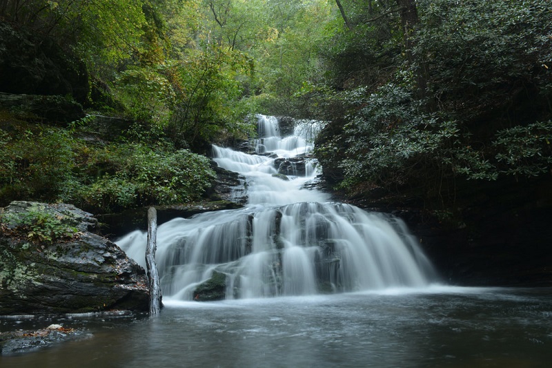
IMPORTANT NOTE: This hike has multiple wet feet creek crossings. You must bring appropriate footwear in order to cross. Also there will be hiking on unmarked paths, closed logging roads, and in some spots, off trail. This is an out-and-back hike with a loop in the middle. Along the way we will have a great vista type view and visit four different waterfalls! The moving pace will be on the slower end of moderate - - between 2 to 2.5 MPH with plenty of breaks (to enjoy the woods and the scenery). The estimated elevation gain is ~2100 feet with some bushwacking and creek crossings. So, I expect this to be on the harder end of a D4 hike. Please make sure you are in good physical condition to handle a hard D4 with wet-foot creek crossings and a little steep bushwhacking. We will leave the carpool location promptly at 7:30 and taking a quick stop in Dahlonega on our way to the trailhead which is 7/10ths of a mile north of Suches. The plan is to start the hike at 9:00 and get back to the trailhead around 3:30 PM. I haven't explored the Canada Creek area before, but from what I have read, the area is worth a visit. Many of you may have seen Woody Lake, a picturesque pond which is at the turn off of Hwy 60 and Hwy 180. Canada Creek is the stream that drains Woody Lake and it drops over four notable waterfalls and through a scenic gorge on its way to the Toccoa River whose water eventually makes its way down to the Mississippi River. The plan is to hike from the parking location up to a vista at the top of Little Cedar Mountain (a very steep initial ascent). Then make our way down to a short, but very steep off- trail route down into the Canada Creek valley to another trail/closed forest road. Along that route we will see Third Falls, Second Falls, then Big Falls. From there we hike back and take a detour to Fourth Falls and circling back taking the trail back to the top of Little Cedar Mountain. If all goes as planned, we should be back at the trailhead parking by 3:30 PM and back at the carpool by about 5:00 PM. For a map of the route plan click the this link
here.
| |||||||
| |||||||
| How to Get There: | |||||||
| Event Directions: | Directions from Suches, GA: From the intersection of Highway 60 and Highway 180 in Suches, follow Highway 60 North for 0.7- miles. There will be a dirt driveway on the right and a pull-off with a gated dirt road on the left. Park at the pull-off on the left. Click here for google map directions from Mansell Park & Ride. | ||||||
| Carpool to Event Distance (round trip): | 120Mile(s) | ||||||
| Carpool Departure Time: | 7:30 am | ||||||
| Carpool Location: | Log in for location | ||||||
| Carpool Directions: | Log in for directions | ||||||
| Carpool Cost: | Estimated cost per vehicle for this event is $48.00 using a reimbursement rate guideline of $0.400 per mile. The total amount should be divided by the number of people in the vehicle, including the driver. This is a guideline, not a rule, for drivers but the cost should not be higher unless there are extenuating circumstances. | ||||||
| Notes: | |||||||
|
* We encourage all members to follow our Etiquette Guidelines while participating in AOC events. | |||||||
Cancellation/Partial Attendance: Please review the AOC cancellation policy. | |||||||
 Calendar of Events
 Event Places