 Print-Friendly Version Print-Friendly Version
|
|
Springer Mountain/ Benton MacKaye Loop (Rescheduled) | |||||||
| The Basics: | |||||||
| Event Type: | Hike | ||||||
| Event Location: |
Springer Mountain Trail head (USFS 42)


| ||||||
| Date(s) & Time: | Fri, Dec 7 2018 7:00 am >> Fri, Dec 7 2018 4:00 pm (Carpool Departure: 7:00 am *log in for location*) | ||||||
| Registration Opens: | Sun, Dec 2 2018 3:00 pm | ||||||
| Registration Cut Off: | Thu, Dec 6 2018 5:00 pm | ||||||
| Event Duration: | 9 Hours | ||||||
| Difficulty Rating: | D4: Moderate to Difficult | ||||||
| Distance: | 8.5 Miles | ||||||
| Pace: | Moderate | ||||||
| Trip Leader(s): | Holt Ward Email Trip Leader(s) Email Trip Leader(s)
You must be logged in to get the Trip Leader contact information. | ||||||
| Member Cost: | None | ||||||
| Participant Info: | |||||||
| Who's Invited: | Members Only, 21 And Older Only | ||||||
| Maximum Group Size: | 10 | ||||||
| Minimum Group Size: | 2 | ||||||
| Number Registered So Far: | 13 / 0 (To see who's signed up, log in to the Member Area) | ||||||
| Are Dogs Permitted: | No | ||||||
| Itinerary: | |||||||
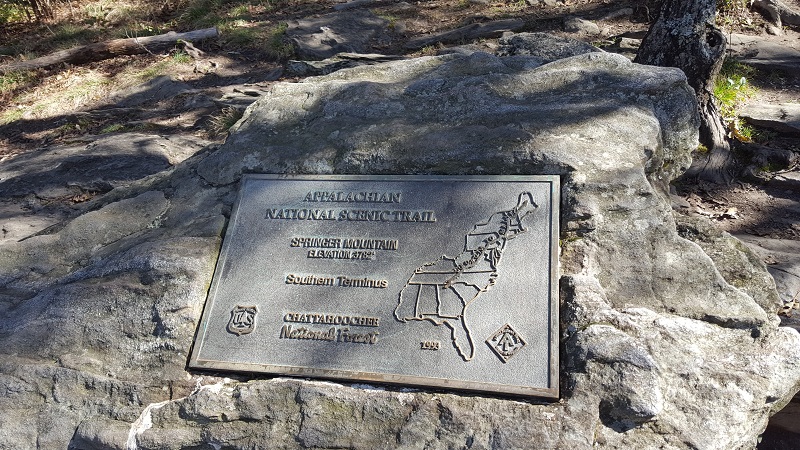
Have you ever wanted to see where the famous Appalachian Trail and Benton MacKaye trails both begin? On this hike, we will hike portions of both of these very famous “long trails” which both begin on the top of Springer Mountain. For this hike, we will start at the parking lot on USFS 42 near the base of Springer. We will initially head north from the parking lot until we reach where the AT and BMT split. We will fork right onto the BMT and follow it generally down towards Big Stamp Gap, crossing several creeks along the way. While there are no long range views in this portion of the hike, the beauty of the foliage and creeks along the way will more than makes up for that. After crossing through Big Stamp Gap, we start climbing up the shoulders of Ball Mountain and then on to the summit of Springer Mountain at mile 3.8 miles. After visiting the bronze plaques and first white blaze marking the beginning point of the AT we will head south on the AT approach trail for about 1.5 miles, reaching the Black Gap shelter where we will break for lunch. After lunch, we will begin the 1.5 mile, 600 foot climb back to the Springer summit. Finally, its a one mile, somewhat steep, rocky descent back to the parking lot and our cars. In total we will cover approximately 8.5 miles and approximately 1500 feet of elevation Suitability: This is not a beginner hike. You should have some D4 or solid D3 experience in your history before signing up for this hike. If in doubt, please contact the Trip Leader to discuss the suitability for this hike.
(Carpool Information) We will be departing from the Old Rope Mill overflow parking lot a little after 7am. Directions to the car pool are listed below. The trip from the car pool location to Springer Mt parking lot is about 1:45 hours. We will plan on finishing our hike no later than 2PM which will allow us to return to the Olde Mill Park overflow by no later than 4pm (and hopefully sooner) I do not recommend that people drive to the trailhead directly unless they have been there before. The route there is a bit tricky with some confusing intersections and will include about 6 miles of gravel/dirt forest service roads. If you prefer to drive yourself, I strongly suggest you meet at the car pool location and caravan with us to the Springer Mt trailhead. | |||||||
| |||||||
| How to Get There: | |||||||
| Event Directions: | Directions to Three Forks Trailhead from Car pool location Coordinates (34.663559, -84.184082)
| ||||||
| Carpool to Event Distance (round trip): | 140Mile(s) | ||||||
| Carpool Departure Time: | 7:00 am | ||||||
| Carpool Location: | Log in for location | ||||||
| Carpool Directions: | Log in for directions | ||||||
| Carpool Cost: | Estimated cost per vehicle for this event is $56.00 using a reimbursement rate guideline of $0.400 per mile. The total amount should be divided by the number of people in the vehicle, including the driver. This is a guideline, not a rule, for drivers but the cost should not be higher unless there are extenuating circumstances. | ||||||
| Notes: | |||||||
|
* We encourage all members to follow our Etiquette Guidelines while participating in AOC events. | |||||||
Cancellation/Partial Attendance: Please review the AOC cancellation policy. | |||||||
 Calendar of Events
 Event Places