 Print-Friendly Version Print-Friendly Version
|
|
Rabun Bald and Flat Top Mountain | |||||||
| The Basics: | |||||||
| Event Type: | Hike | ||||||
| Event Location: | Rabun Bald, 15 miles northeast of Clayton, GA | ||||||
| Date(s) & Time: | Wed, Jun 17 2009 9:30 am >> N/A (Carpool Departure: 7:30 am *log in for location*) | ||||||
| Registration Opens: | Wed, Jun 3 2009 7:00 pm | ||||||
| Registration Cut Off: | Tue, Jun 16 2009 8:00 pm | ||||||
| Event Duration: | 11 hours, hiking and drive time | ||||||
| Difficulty Rating: | D5: Difficult | ||||||
| Trip Leader(s): | Jennifer Rush Email Trip Leader(s) Email Trip Leader(s)
You must be logged in to get the Trip Leader contact information. | ||||||
| Member Cost: | None | ||||||
| Participant Info: | |||||||
| Who's Invited: | Members Only, 21 And Older Only | ||||||
| Maximum Group Size: | 20 | ||||||
| Minimum Group Size: | 4 | ||||||
| Number Registered So Far: | 10 / 0 (To see who's signed up, log in to the Member Area) | ||||||
| Are Dogs Permitted: | No | ||||||
| Itinerary: | |||||||
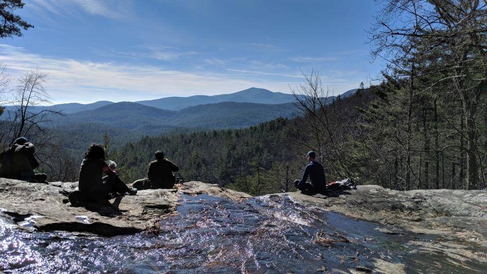
| This trip is for advanced hikers with recent experience of hiking 10 or more miles in the mountains. We will go at a steady, moderate pace, with some stops. This is an in and out hike with a total distance of 12 miles and vertical rise of 3,000 feet. We will be summiting 2 mountains on this hike including Rabun Bald and Flat Top Mountain. Rabun Bald is the second-highest mountain in Georgia and the highest foot-access-only mountain. If features a 360 degree vista from a wooden deck perched above a rustic stone lockout tower at 4,696 feet. We will be hiking west on the Rabun Bald Trail from the parking lot for 2.9 miles to reach the summit of Rabun Bald climbing 2,100 feet. We will then continue on the Bartram Trail for approximately 3 miles to reach the summit of Flat Top Mountain. We will turn around and backtrack the way we came. | |||||||
| |||||||
| How to Get There: | |||||||
| Event Directions: | North of I-85 from the park and ride. Take exit 113 onto I-985 North. I-985 North will turn into highway 441. Follow highway 441 north into Clayton, GA. From just North of the junction of US 76 West and US highway 441 in Clayton, GA make a right onto Warwomen road and drive 10 miles to Forest Road 7, Hale Ridge Cemettery Road. Turn left and go 5.6 miles to a gap. The trail starts on the hill to the left of the gap. There is roadside parking on the right, just past the trail. Watch carefully; this trailhead is not well marked. | ||||||
| Carpool to Event Distance (round trip): | 200Mile(s) | ||||||
| Carpool Departure Time: | 7:30 am | ||||||
| Carpool Location: | Log in for location | ||||||
| Carpool Directions: | Log in for directions | ||||||
| Carpool Cost: | Estimated cost per vehicle for this event is $80.00 using a reimbursement rate guideline of $0.400 per mile. The total amount should be divided by the number of people in the vehicle, including the driver. This is a guideline, not a rule, for drivers but the cost should not be higher unless there are extenuating circumstances. | ||||||
| Notes: | |||||||
|
* We encourage all members to follow our Etiquette Guidelines while participating in AOC events. | |||||||
| Cost Includes: | Share gas expense with your carpool driver | ||||||
Cancellation/Partial Attendance: Please review the AOC cancellation policy. | |||||||
 Calendar of Events
 Event Places