 Print-Friendly Version Print-Friendly Version
|
|
Cumberland Trail Laurel-Snow Segment (Rescheduled) | |||||||
| The Basics: | |||||||
| Event Type: | Hike | ||||||
| Event Location: |
Dayton, TN


| ||||||
| Date(s) & Time: | Sat, Apr 13 2019 7:00 am >> Sat, Apr 13 2019 5:30 pm (Carpool Departure: 7:00 am *log in for location*) | ||||||
| Registration Opens: | Mon, Apr 1 2019 7:30 pm | ||||||
| Registration Cut Off: | Fri, Apr 12 2019 8:25 pm | ||||||
| Event Duration: | 10 Hours 30 Minutes | ||||||
| Difficulty Rating: | D4: Moderate to Difficult (Exploratory) | ||||||
| Distance: | 10 Miles | ||||||
| Pace: | Moderate | ||||||
| Trip Leader(s): | RonnyJ (Call me Ron) Email Trip Leader(s) Email Trip Leader(s)
You must be logged in to get the Trip Leader contact information. | ||||||
| Member Cost: | None | ||||||
| Participant Info: | |||||||
| Who's Invited: | Members Only, 21 And Older Only | ||||||
| Maximum Group Size: | 12 | ||||||
| Minimum Group Size: | 3 | ||||||
| Number Registered So Far: | 4 / 0 (To see who's signed up, log in to the Member Area) | ||||||
| Are Dogs Permitted: | Yes | ||||||
|
Note: This is an "EXPLORATORY" trip. This means that there are parts of this trip, or perhaps the whole trip, that is new to your Trip Leader(s). However, they are confident that this will not be an issue. This note is here so that you can make an informed decision. When a Trip Leader isn't personally familiar with a trip, there is an increased chance of things not going as planned and you need to be prepared. The Trip Leader may have additional details in the itinerary. | |||||||
| Itinerary: | |||||||
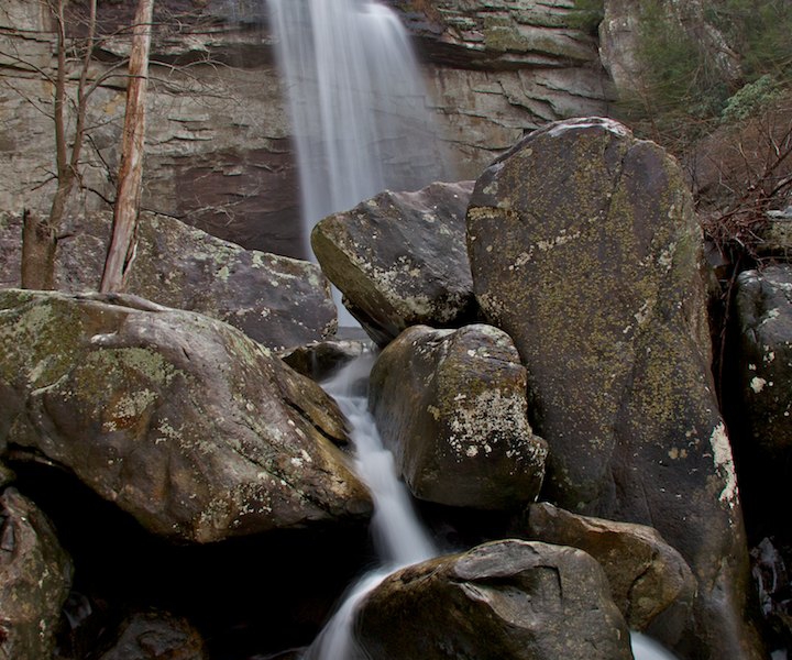
Rescheduled to Saturday to avoid severe ThunderstormsCT Laurel-Snow SegmentJoin me as I continue to explore the southern portion of the Cumberland Trail. The Cumberland Trail is an ambitious hiking trail project currently under development. When completed, the CT will extend more than 300 miles from the Cumberland Gap in Kentucky to Signal Point, just outside of Chattanooga. Currently over 200 miles are open with the trail slated for completion in late 2019. Additionally, the CT is part of the Great Eastern Trail, which is under development and will extend from Alabama to New York when completed. Laurel- Snow This section is filled with difficult terrain, rock scrambles, waterfalls, gorges, awesome vistas and cool bridges. If you are looking for a hike on an iconic trail with tons of cool stuff to see, this is your hike! We will be stopping at all points of interest for picture taking and high hilarity. This is an out and back hike. If you have not been on the Cumberland Trail, you have been missing out! The trail is interesting, difficult and BEAUTIFUL! We will be starting at the trailhead just North of Dayton, Tn. Dayton is known for being the scene of the famous "Scopes Monkey Trial" in 1925. The trail hugs scenic Richland Creek for 1.6 miles before ascending out of the gorge, via difficult terrain with a dash of rock scrambling, and heads for Laurel Falls. Laurel Falls is an 80 foot stunner that will serve as subject for many of our photos. After the falls, we go back on the trail to ford Laurel Creek (expect wet feet) and head towards the Laurel Creek Overlook followed by Bryan Overlook. While we are at Bryan Overlook we will be able to see, across the gorge, Buzzard Point Overlook, which is our last planned stop. After enjoying the overlook, back down the gorge we go where a 150 foot bridge awaits our crossing. After the bridge comes the rugged climb up the other side of the gorge where we will head for Buzzard Point Overlook. If we haven't had our lunch yet, we will stop here for lunch. If we still have energy, we will swing over to Dunn Overlook and Snow Falls. This 2.3 mile addition will be at the discretion of the trip leader and will not add much in terms of difficulty to the hike. This 10 mile hike features rugged terrain, rock scrambles and a creek crossing. You will need to bring water shoes. You must have recent D4/D5 experience, be comfortable with a pace on the fast side of moderate and be prepared for difficult terrain to participate in this event. There are no bathrooms at the trail head. | |||||||
| |||||||
| How to Get There: | |||||||
| Event Directions: | Directions to the trailhead can be found here: https:/ /goo.gl/maps/ aSVQdNcbvPw Or enter "Laurel Snow State Natural Area" in your GPS app. | ||||||
| Carpool to Event Distance (round trip): | 250Mile(s) | ||||||
| Carpool Departure Time: | 7:00 am | ||||||
| Carpool Location: | Log in for location | ||||||
| Carpool Directions: | Log in for directions | ||||||
| Carpool Cost: | Estimated cost per vehicle for this event is $100.00 using a reimbursement rate guideline of $0.400 per mile. The total amount should be divided by the number of people in the vehicle, including the driver. This is a guideline, not a rule, for drivers but the cost should not be higher unless there are extenuating circumstances. | ||||||
| Notes: | |||||||
|
* We encourage all members to follow our Etiquette Guidelines while participating in AOC events. | |||||||
Cancellation/Partial Attendance: Please review the AOC cancellation policy. | |||||||
 Calendar of Events
 Event Places